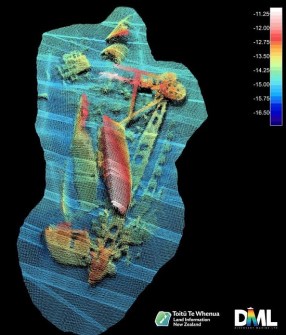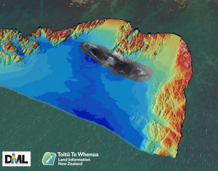
Two previously uncharted shipwrecks have been revealed and mapped during a hydrographic survey of Tūranganui-a-Kiwa/Poverty Bay, in the Gisborne region on the north-eastern coast of New Zealand’s North Island.
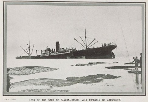
The Toitū Te Whenua Land Information New Zealand (LINZ) survey of the Gisborne area uncovered the vessels: the hull and deck structure of the 7280-tonne steamer Star of Canada, which ran aground off Kaiti Beach on 23 June 1912, and the wreck of a barge used to dredge Napier and Gisborne harbours in the 1930s.
“It’s always satisfying when our surveys reveal features that were either unknown or uncharted,” said LINZ Principal Geospatial Specialist Stuart Caie.
“Advances in technology mean that each time we resurvey an area we uncover details that were previously unknown. In this case, the last survey was done in the 1950s by the Navy and the echosounding technology used this time has given us far greater coverage of the seafloor than ever before.
“While the local community is aware of these wrecks, they have never been charted.”
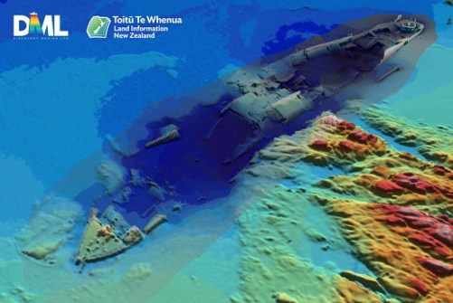
The Star of Canada regularly sailed from Australia and New Zealand to England between 1910 and 1912, carrying chilled and frozen meat and other produce.
On 23 June 1912, a squall blew the vessel onto Kaiti Beach where it grounded just off the rocky shoreline and began taking on water. Fortunately, no lives were lost, but the vessel had to be abandoned.
The other wreck comprises the remains of the dredge Korua, which was scuttled off Young Nick’s Head when it was no longer of use.
Data captured in the overall survey, including details of the wrecks, will be used to update nautical charts of the area.