


Victoria’s ongoing Vicmap Spatial Upgrade has now seen 3.25 million of 3.8 million parcels upgraded, with the emphasis now on adding rural and regional areas.
Forty-five municipalities have been fully integrated into the Spatial Upgrade since commencement of the effort in October 2022, with integration of 49 of 80 municipalities due to be completed by the end of 2023.
The Upgrade incorporates eight Vicmap products: Vicmap Property, Vicmap Address, Vicmap Admin, Vicmap Crown Land Tenure, Vicmap Features of Interest, Vicmap Hydro, Vicmap Index and Vicmap Transport.
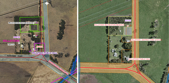
The effort is already showing results, delivering spatial accuracy improvements across the state. The example pictured below shows a property boundary and road casement shift by close to 20 metres following the Upgrade.
The schedule of upgrades, listed by local government area, can be found online. Upgrades scheduled up to the end of February 2024 are listed, with more LGAs still to be added through to June 2024.
The Vicmap spatial upgrade is an outcome of the state’s Digital Cadastre Modernisation project.
A Readiness Toolkit is available to assist Vicmap users understand and make use of the changes to Vicmap.


