

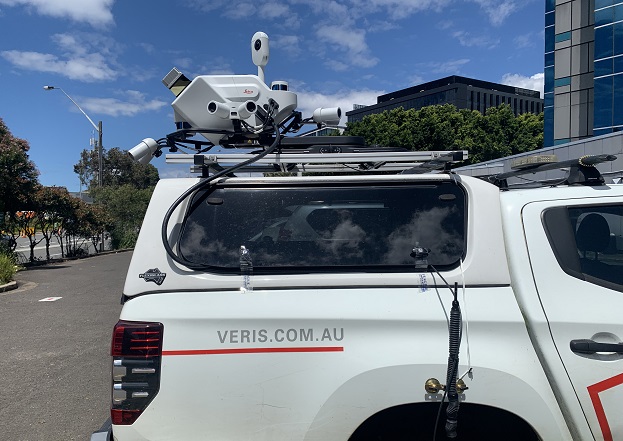
The Leica Geosystems Pegasus TRK vehicle-mounted scanner is making surveying safer and far more cost effective.
PARTNER FEATURE
When one of Veris’ clients needed to quickly survey hundreds of newly installed street furniture assets within the busy CBD of an Australian capital city, the company turned to the Leica Geosystems Pegasus TRK vehicle-mounted scanner to do the job.
The aim of the project was to ensure that the streetside assets were sited and built as stipulated by the client and in accordance with requirements specified by the relevant governmental authority. With the assets initially installed, liability for any problems — graffiti, car accidents, pedestrian accidents — remained with Veris’ client until such time as the client could assure its client that the assets had been installed correctly… whereupon liability would then transfer to that ultimate client. In order for this to happen, a survey would need to be undertaken.
All up, there were 500 individual assets within the CBD area that needed to be checked.
“We looked at the safest way to execute it and the most efficient way to execute it,” said Vassili Galettis, Client Director at Veris. “That’s where we came up with the TRK solution, and its ability to handle urban canyons, tall buildings and a GNSS-denied environment.”
“It meant we could use it’s SLAM capability to produce an accurate, geo-referenced point cloud, from which we could extract the information required,” said Galettis.

The client had already broken the back of the asset installation work, with 70% of the job completed. This meant that Veris could get the project done in a fast timeframe, which in turn meant that client’s liability obligations would be assured in an expedited manner.
“And that enabled them to hit their program targets,” said Galettis. “They would have been looking at months of data capture the traditional way as opposed to just days with the TRK.”
Veris conducted the survey during the daytime because they saw the value in having imagery of the assets, not just the LiDAR data. “We did multiple runs along each of the streets, and the beauty of the TRK is you have the ability to merge the data from the runs and remove unwanted items,” said Galettis.
That ability to simultaneously capture both LiDAR data and imagery meant that not only was it possible to capture the XYZ coordinates of the assets (which related back to the civil authority’s requirements) but also to formally prove the condition of each of those assets at the time of capture.
The difficult GNSS conditions along the CBD routes due to the tall buildings and urban canyons, meant that the TRK’s SLAM capability (which assists with trajectory accuracy through GNSS denied areas) made it the ideal choice for the project.
Hardware and software
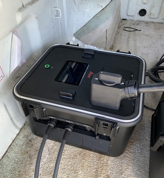
A typical TRK installation comprises the scanning unit, a control unit and a battery unit. The control unit enables the user to go straight from data capture to processing on-the-fly — no more time-consuming transcoding, storage overhead or errors during data transfer. And the battery unit is expandable, with up to three batteries for up to 21 hours of operation or for hot-swapping for continuous power.
The integration of IMU and SLAM technology enables georeferencing in challenging GNSS-denied environments. Precision RTK positioning gives location accuracy down to the centimetre, in real-time. And weighing in at just 18 kg with its rotating-tilt mounting platform, the Pegasus TRK can be safely set up and operated by just one person.
According to Galettis, “one of the main advantages of the TRK is its ability to quickly handle large datasets, and the ability to get the information out of the machine with relative ease”.
The Leica Pegasus FIELD software enables users to plan routes and set goals for each project from the office or in the field. Data acquisition considers satellite availability and signal coverage for automated routing, while edge computing and on-the-fly processing means data is collected and enhanced in real-time — at the speed of the traffic. The software guides the user through project set-up and planning, with an option to use predefined profiles to achieve the best possible results.
Leica Cyclone Pegasus OFFICE provides the data flow into the post-processing and publishing workflows. Users can complete all their processing requirements in the one solution, including refining data with precision geo-referencing and multi-pass trajectory adjustment, and creating colourised 3D point cloud data that is automatically privacy compliant.
Safety boosted, costs saved
“Keeping people out of live environments is key, and safety is at the top of what we do,” said Galettis. “Our greatest safety risk as a company is either driving a car or being roadside doing survey work.”
“To execute a contract such as this in the traditional way, we would have been looking at traffic control requirements, a multiple night shifts, road occupancy licenses, access roads — it would have been difficult to try to provide the deliverables the client was after while maintaining safety,” he added.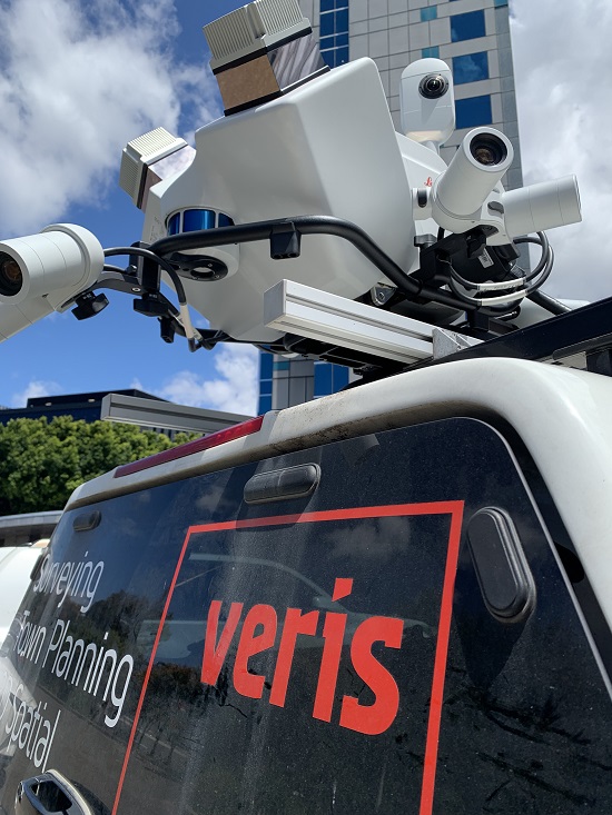
Naturally, this led to substantial cost savings all along the line… not just survey related costs but also project-related costs. Plus, as outlined, the client could reduce its liability risk by transferring control to the ultimate owner of the assets far sooner.
“Veris has always been on the cutting-edge of spatial data management and data capture technology on infrastructure projects both small and large,” said Galettis. “The TRK helps us continue this tradition.”
For more information about the Leica Geosystems Pegasus TRK, go to survey.crkennedy.com.au.


