

The efficient delivery of services using fewer resources will require an ever-evolving geospatial ecosystem.
By Lyn Terrett
Which should come first when supporting our critical infrastructure — digital twins, AI or data integrity? And where should we place our focus when supporting smart city management?
Funding to address the evolving challenges of our expanding dynamic urban landscapes alongside climate-related disasters, is tight. Infrastructure in Australia is valued at around $550 billion, and it is estimated that $20 million (or $800,000 per hour) is spent each day on asset management and maintenance activities.
That’s why the integration of geospatial data and technologies such as digital twins, AI, machine learning, the IoT and 5G will enable us to form collaborative partnerships for a sustainable future, while making the most of limited financial resources. At the recent International Public Works Conference (IPWC) in Adelaide, delegates (largely local government and utility engineers) sought insights into how to be more effective at asset management.
IPWC streams covered topics such as managing the environment and climate change, asset management, roads and pavements, and a special section called ‘Good Stuff,’ which was a catchall for several innovative presentations covering smart technologies largely underpinned by spatial data and map-centric visualisations.
What was obvious was how important every aspect of the spatial industry and our highly skilled practitioners are in empowering real innovation in public works. Our role is to provide the location-based data needed for service-level priorities to drive the best allocation of funding and resources, and so that assets such as roads, bridges, buildings and stormwater networks will have longer, more useful lives. There was also an overwhelming interest in using digital twins, AI and machine learning to overcome the shortage of civil engineers and public works asset management practitioners.
Having undertaken research in AI feature extraction — from the rapid collection of spatial data using different sensors combined with advanced GNSS and IMU technologies — it is very clear that behind every future effective asset manager will be a digital inspector based on AI technology.
AI and machine learning IPWC presentations were largely directed toward rapidly identifying defects, such as using imagery and other sensors to spatially find and identify such defects along roadways and from CCTV along drainage and wastewater pipes.
Digital twins and digital cities will need systematic integration of geospatial technologies with dynamic inputs to enable effective decision making by stakeholders, and to automate workflows to serve, protect and provide liveable cities and sustainable environments.
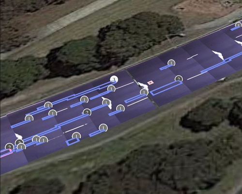
AI is being used to assess road scans to spot areas where the asphalt has cracked (blue rectangles).
But how will the spatial community address the gaps and communicate the value proposition of geospatial knowledge as the centrepiece for collaborative partnerships? And how will it facilitate the transfer of responsibilities across organisations and people to manage the infrastructure and environment, when the problems are due to the lack of data integrity? The NBN rollout and light rail projects in Sydney are stellar examples of what happens when the underlying design and construction data is old and out of date.
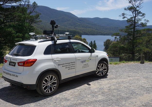
From our experience at RapidMap, the possibilities are endless — developing 360° mobile camera capture to create personalised road corridor street views for road authorities, local government and road maintenance contractors with UI measuring tools; spatial data measurement and attribute capture, feature extraction, building classification engines using all the above frontier technologies; and an emphasis on PNT, quality sensors and high-resolution imagery.
The more efficient delivery of services across the nation while using fewer resources will require an ever-evolving geospatial knowledge ecosystem… and it highlights the need for Australia to develop smart communities of business and government experts who work in partnership.
Fortunately, just as the IPWC event supports public works engineers, we have SSSI and SIBA|GITA to promote geospatial knowledge collaboration in affordably extending the lifespans of infrastructure — through proactive maintenance via digital twins, AI and sensors — rather than having to deal with massive replacement costs in the future.
So, what is the priority from my perspective? Data integrity with positional accuracy. It might cost more to capture data the right way, but it is a better investment in the long run.
Lyn Terrett is Spatial Technologies Director at RapidMap and Iconyx.


