


This week: Lots of job vacancies, industry PhD programs, take part in a VR trial, create a cartoon and more.
Search results for "unsw"

Drone imagery, field mapping for WA gold mine
Austin Metals has begun a high-res drone imagery and field mapping program at its Austin Gold Project in WA.

PNT2026 conference is only one week away
More than 200 positioning, navigation and timing experts are about to descend upon Sydney for the new PNT conference.
Best of 2025: The need for a Resilient PNT CRC
Leading geospatial experts say the time is right for Australia to develop and strengthen its PNT capabilities.

Spatial Snippets for Wednesday, 12 November
This week: WA’s new spatial cadastre, place name awards, SAR satellite launches, history of mapping and more.

Spatial Snippets for Wednesday, 22 October
Enjoy our weekly compilation of general geospatial news snippets from across Australia and around the world.

Team tackles timely flood analysis using SAR, EO
SmartSAT CRC, industry and academia are using satellite radar and optical data to quantify major flooding events.
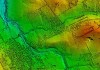
Mapping to predict lightning strikes and fires
The first round of data collection for the IGNIS Project involved 50 flying hours covering 10,000 km.

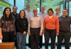
MapAI CEO departs; FrontierSI CEO steps in
FrontierSI’s Graeme Kernich will serve as interim CEO of the AI-based geospatial data analytics start-up.
Australia’s need for a Resilient PNT CRC
Leading geospatial experts say the time is right for Australia to develop and strengthen its PNT capabilities.