


A 3D Point cloud dataset cannot be used to its full potential without the experience of GIS professionals combined with the latest technology in the advanced processing software. Datasets generated by laser scans such as LiDAR can be inefficient, unclassified, slow, incomplete, and noisy. Thus, efficient platforms are necessary to make them more usable for the people handling the data. We are here to do all the heavy lifting for you and your teams.
What is ScanX?
ScanX is a web-based point cloud processing platform that helps speed up the treatment of 3D scans through our patent-pending automated workflows. Alongside our combined 20 years of industry experience in surveying, spatial sciences, and aeronautical know-how, we have created a feature-rich and easy-to-use interface that is powered by the cloud architecture of Bezos.
![]() Explore how ScanX’s integrated platform can provide an automated classification system to enable greater optimization of your laser point clouds.
Explore how ScanX’s integrated platform can provide an automated classification system to enable greater optimization of your laser point clouds.
Traditional Post-Processing Platforms
Outdated point cloud processing systems are very complicated to work with. They require intensive components such as heavy-duty CPUs, GPUs, and even RAM. This makes them hard to access especially for those who just want to view or visualize 3D data.
Software pricing can also be an issue since one license can cost thousands of dollars. Thus, collaboration is very limited as it entails multiple licensed instances of the platform.
Another fact to take note of is that traditional post-processing platforms are hard to master. A single-screen can have multiple tools, layers, and views that can be jarring especially for beginners.
As a result, more time needs to be spent learning the ups and downs of a selected platform.
Advantages of ScanX
Ease of Use
ScanX has a very beginner-friendly user interface designed for everyone who wants to gain full control of 3D point cloud data. The whole process involves uploading, automating, visualizing, and sharing your raw 3D scans.

Automated Classifications
ScanX is a fully functional, browser-based cloud processing tool. It removes the need for power-intensive PCs as you can access the platform on the internet. This also greatly helps in reducing storage clutter, as heavy 3D scan files become stored in the cloud. View very large point clouds in seconds… do not get stuck loading your assets and waiting 2 hours before a meeting.
Minimal Requirements
With ScanX, there is no need to manually classify different objects. One quick click can easily classify trees, ground, powerlines, vehicles, and buildings. Noise removal is also faster and more efficient, thanks to the smart algorithm that we have developed.

Industries Served
Forestry
ScanX has worked with industry leaders and public sectors in the forestry domain. Co-developed with Mr. Itakura (University of Tokyo), forestry metrics such as Tree IDs, trunk diameters, and canopy diameters can be calculated automatically with just one click on our platform. This enables any industry to automate and standardize to measuring trees and carbon data, paving the way for unlimited potential in the future.
Here at ScanX, we are developing solutions that impact the environment we live in.

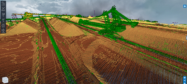
Mining
In the mining sector, ScanX can be used to visualize and calculate the total volume of a specific mineral reserve. Information on bare earth can be automatically processed despite the existence of infrastructure and vegetation. Filter out all the noise and extract the ground for accurate and repeatable stockpile measurements! Our CTO has over 10 years of experience on the field and completely understands the complexes of haul trucks, LVs, and infrastructure on sites.
It also helps in accessing data on terrains that are previously impossible to reach.
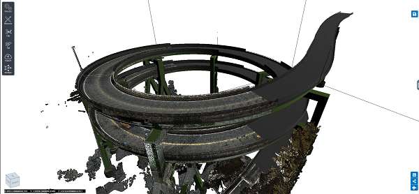
Construction
ScanX can assist construction firms and companies in optimizing their workflows and reducing the time taken in surveying. The platform opens up new doors of opportunities including better site-to-office teamwork, powerline and ground classification, as well as machine-learning segmentation.
Instead of waiting for hours and even days of classifying processes, ScanX can analyze construction-related scans in mere minutes. These features give way to heightened efficiency on any surveyor or engineer’s side. Get your ground contours in seconds, not waiting for consultants to manually handle the data only to give you delays.
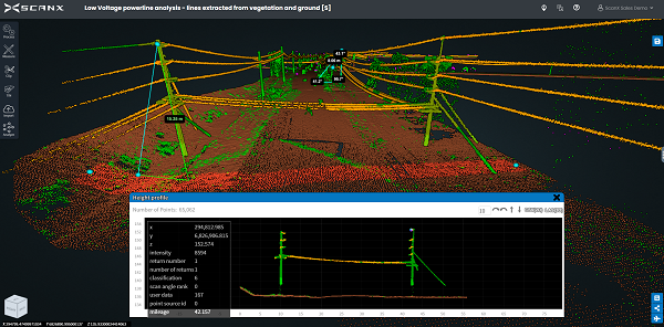
Infrastructure Inspection
ScanX excels in assessments of various infrastructures. It is capable of road safety analytics which efficiently measures road widths and dimensions for regulation purposes.
Inspecting old buildings can also be risk-free with our platform, as there is no need to go to the site itself. Clip and cut up your scans to see through walls; also measure your changes in mm!
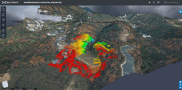
Disaster Management
ScanX reduces risks that can happen in the workplace. For example, our waterway analytics can identify danger zones filled with water that can cause vehicular accidents.
The same can be said for analyzing areas that have been struck by natural calamities. ScanX can automatically classify different objects and give out data to authorities for a proper action plan.
Below is a laser scan during a mudslide disaster in Atami City, Shizuoka that was processed with the help of ScanX. With the speed and efficiency of our platform, concerned organizations were able to quickly respond to the needs of the area.
Get Started With ScanX
If you want to get the best benefits out of your 3D scans, ScanX is the best processing software available in the market. We offer a 14-day free trial, as well as meetings and conferences to introduce our function, operation, and benefits for your industry.
ScanX also partners with many global companies in the point cloud, UAV, and LiDAR technology industries. We aim to push innovation on 3D data capture and processing to new heights.
Don’t get left behind by the changing times, and give your team access to the latest tech without the overheads.
ScanX users can choose from three tiers of services: Free, Business and Enterprise plans. A 14-day free trial is available and monthly plans start at $299 (US) per month to suit a variety of user needs. Interested users can register for the free trial at https://scanx.com/try-for-free/.
Information provided by ScanX


