


Martine Woolf leads a team of Geoscience Australia experts who are implementing Australia’s next-generation positioning projects. In this interview, she outlines some of the amazing work being done to upgrade Australia’s vital positioning systems.
Please tell us about your career background and your current role.
Throughout my career, I have worked on spatial data applications, both in government and industry. I have worked at Geoscience Australia for about 12 years now, since moving to Australia with my family. In that time, I have led teams to deliver programs in natural disaster analysis, resources advice, and now positioning. Before that, I worked for a global disaster risk modelling company, following a PhD in environmental systems science. In my current role as Branch Head of Positioning Australia, I lead an amazing and diverse team who are all committed to delivering better positioning for Australia. I enjoy working in technical organisations. I am inspired by the passion and excitement across our teams, where people contribute their specialism to deliver something for stakeholders that is bigger than the sum of the parts.
The NPIC is described as adopting a ‘unified’ approach to ensure consistent, fit-for-purpose data. What is meant by ‘unified’?
Over the last 20 years the Commonwealth, state, territory governments and industry have built localised networks of positioning infrastructure. These networks have been focused around urban areas, or around industry-specific sites like mines or farms. In most cases, there has been limited coordination between operators, and there was no single standard to which these networks adhere.
What the National Positioning Infrastructure Capability (NPIC) provides is a unified approach to the management of the nation’s positioning infrastructure. That means NPIC provides the standards and framework that operators can follow to ensure that consistent, fit-for-purpose data and services are available to government, business and academia.
Through NPIC, everyone has access to high-quality data and services from certified reference stations. Station operators are supported in the establishment, operation and sharing of their infrastructure. Coverage of positioning services has been expanded and is consistent between providers. Service providers have increased ability to cover new regions and stakeholders, and to tailor offerings to different industry sectors.
The NPIC network currently consists of over 700 continuously operating reference stations (CORS) from 11 different operators. This network supports the delivery of centimetre-level positioning across areas of mobile phone coverage in Australia.
What can you tell us about work to modernise the ARGN?
The Australian Regional GNSS Network (ARGN) provides the geodetic framework for all spatial data in Australia. The network was originally established in the early 1990s and has evolved through programs such as AuScope.
Under the NPIC, Geoscience Australia has been able to modernise and expand this network to span all of Australia and its external territories. The final network will consistent of 200 stations that have a consistent build.
The modernisation has included:
- Upgrading the infrastructure to a modern, resilient design
- Ensuring the stations are fully multi-GNSS compliant
- Focusing on the accurate and timely delivery of data in real-time
- Ensuring we have secure, long-term land tenure and access to all stations
- Maturing our approach to operating the network to support existing and emerging industry users.
While rolling out a national infrastructure project during a global pandemic has been a challenge, we have been able to continue to progress ARGN delivery through strong partnerships with Australian industry. There are currently 154 stations that have been upgraded to the new consistent build, with the remainder under contract and scheduled for delivery by the end of September 2023.
What can we expect from the new versions of Ginan coming in the next 12 months?
Ginan is Geoscience Australia’s Analysis Centre Software. It is designed as an open-source toolkit for creating precise point positioning (PPP) analysis products, correction streams and positions. It is being actively developed as part of our Positioning Australia program. Geoscience Australia is establishing an operational instance of Ginan that produces PPP analysis products and streams on a continuous basis and which are available free of charge to the public.
The source code for the current version (1.5.3) of Ginan is available for download from the GitHub. New versions of Ginan with enhanced capabilities will be developed and released over time.
Ginan version 2.+ (to be released mid-2023) will deliver:
- Unified user and network operation modes (one observation model and filter)
- Full multi-constellation capability
- Better internal frequency indexing (complete multi-frequency capability
- UnCombined/UnDifferenced (UDUC) processing (v1.5.3 is ionosphere-free only)
- Integrated and coupled precise orbit determination (POD) capability
- More robust data handling in the filter for cycle slip and outlier detection and removal
- Complete RTCM3 phase 1 and Phase 2 message decoding and encoding
- Satellite laser ranging data handling fully implemented
- Performance improvements
Ginan version 3.+ (scheduled for late 2023) will deliver:
- The development of a Ginan Geographical User Interface (G-GUI) to help users derive the most benefit from of the software. This may be allied with new distributions to make installing the software simpler — on Windows machines for example.
- The consolidation of Ginan products to confirm data accuracy and availability, benchmarked against the International GNSS Service to provide users visibility of the product quality.
- The further development of algorithms that enable Ginan to produce atmospheric (troposphere and ionosphere) products to be delivered as real-time correction streams enabling a full PPP-RTK capability.
- Some specific functionality including:
- Box and wing solar radiation pressure (SRP) and Earth albedo modelling of GNSS satellites
- Precise orbit determination capability, including for low Earth orbit (LEO) satellites
- Site specific tidal and non-tidal atmospheric pressure loading models
- Hydrological loading models
- Data product combination capability enabling combination of geodetic products from multiple geodetic techniques and analysis packages
- Performance, accuracy and latency improvements.

Access to and provision of free and open data seems to be important. Has it been difficult to arrange this?
By providing access to free and open positioning data and services, the Positioning Australia program is encouraging innovation, and enabling industry to offer new services, both of which are leading to economic growth across several industry sectors — including the geospatial sector.
To deliver NPIC and SouthPAN services, we have relied on our partnerships with government and industry. We have been fortunate that industry have seen the value in partnering in a national capability, despite a perception that NPIC could be competing with their offerings. The way I look at this is that we are not competing but rather enhancing industry offerings. For example, many positioning service providers combine our free and open data with their offerings, adding value to their existing services.
Through NPIC we have partnered with 10 CORS network operators from across government and industry to license data from over 500 stations. In doing this we have been able to support the operators in maintaining and enhancing this infrastructure to improve accuracy and resilience.
The benefits of free and open data and services are considerable. For example, SouthPAN, which went live in September 2022, is estimated to inject at least $7.6 billion of economic benefits to Australia and New Zealand over 30 years.
We are also seeing the benefits from NPIC with the number of users consuming the data from NPIC continuing to grow. We now have over 2,000 registered users of our data streams, many of whom are on-selling services. This includes new companies and new offerings from existing companies.
We are also starting to see some specific benefits in the research and innovation space:
- Ginan is being actively used by the research community to better understand the effects of the ionosphere on positioning, and to investigate the potential of GNSS for disaster warnings
- Industry-led value-added resellers are connecting to the Ginan real-time data streams for product testing and validation.
GA and LINZ had to prepare for initial SouthPAN services during COVID. How much of a challenge was this?
Rolling out a complex space program such as SouthPAN is always a challenge, and COVID complicated that further. The SouthPAN project team is spread across Geoscience Australia and Toitū Te Whenua Land Information New Zealand (LINZ). This means we spend a lot of time online each day, as we work closely together on all aspects of the project. Not only has there been a high pace over these last few years, the team has also grown significantly over that time. Working across countries and time zones had always meant that the SouthPAN team would need to collaborate remotely. COVID only emphasised the adoption of inclusive ways of working with a remote team.
So, on the one hand, COVID absolutely was a challenge during the last few years. On the other hand, we benefited from our geographically dispersed team. We already had established working practices that stood us in very good stead when borders were closed, and afterwards. We now have even our Australian team spread across the country. You could say it challenged any assumptions that you need to ‘be together to work together’. That said, we were very happy to meet for our first face to face workshop after borders reopened!
How will SouthPAN be of benefit for safety-of-life applications?
Integrity and trustworthiness are the key performance criteria for safety-of-life (SOL) applications. Stand-alone GNSS is currently used by aircraft almost everywhere in the world for safe navigation down to the runway approach phase and has been standardised by the UN International Civil Aviation Organisation since the 1990s. However, avionics must make conservative assumptions about errors on GNSS signals to achieve the required level of integrity. This results in lower navigation performance compared to non-SOL systems that do not need to make these conservative assumptions.
The advent of Satellite Based Augmentation System (SBAS) services enable SOL users to maintain the required level of integrity while achieving better guaranteed accuracy. In the case of aviation, this means the aircraft can safely get closer to the runway during bad weather, decreasing the chance the pilot needs to divert to another airport. Of course, availability is also important. SouthPAN is designed to achieve a high level of availability, so pilots can use it when they have the need.
Have you had any feedback from early SouthPAN users?
While it is only early days for SouthPAN, with early Open Services available for only just over six months, early indications are that SouthPAN is being used as a cost-effective way to capture sub-metre positioning without the need for high-cost surveying equipment, particularly in areas without mobile phone coverage. All indications are that SouthPAN early Open Services are meeting a range of different requirements. The potential users and uses of SouthPAN will continue to expand as Geoscience Australia and Toitu te Whenua Land Information New Zealand gradually improve the resilience and redundancy in SouthPAN to be certified for safety-of-life applications.
If I want to use SouthPAN, do I need to buy new equipment?
Many consumer devices already have the required hardware and electronic chips to receive the SouthPAN services. Some devices will pick the early Open Services up now; others may require a firmware update or a more significant upgrade. For example, we received an enquiry by a user who notified us that they received SouthPAN on their new mid-range smartphone. We encourage you to check with your equipment manufacturer about whether your device can access PRN122 or SouthPAN.
Geoscience Australia is working with FrontierSI to provide technical support to users for adopting SouthPAN and demonstrating its benefits. This includes testing receivers and liaising with equipment manufacturers to be able to increase the number SouthPAN compatible equipment.
Is SouthPAN free to use? Is there any cost to using it?
SouthPAN is a free and open service, which can be used without subscription fees, on compatible equipment.
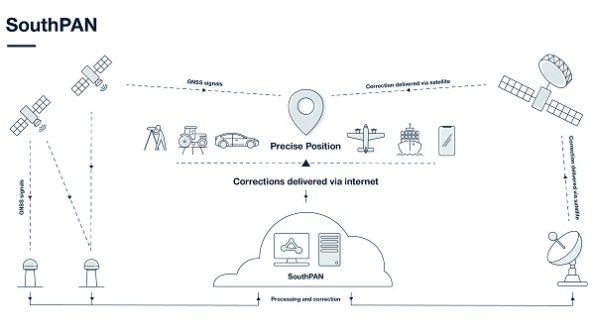
What is the status of the roll out of the SouthPAN ground reference stations?
There will be 35 SouthPAN ground reference stations across Australia and New Zealand and their Antarctic territories. At present, we have not yet started construction; we are identifying and surveying suitable sites. SouthPAN early Open Services are currently delivered through stations in our existing ground reference networks via NPIC.
What are the plans for the two new SouthPAN GEO payloads?
Geoscience Australia is currently in the procurement phase for the two SouthPAN GEO payloads.
What’s the next step after the current early services stage?
As we roll out development of SouthPAN, additional infrastructure will be integrated into the SouthPAN system that will improve accuracy and availability of Open Services. The additional GEO payloads will introduce a new navigation signal that is used for the precise point positioning (PPP) via SouthPAN services. We expect the system to achieve Full Operating Capability, including safety-of-life certification, by 2028.
How can people find out more about SouthPAN and how to make use of it?
More information on SouthPAN is available on the Geoscience Australia and Toitū Te Whenua Land Information New Zealand (LINZ) websites at www.ga.gov.au/southpan and https://www.linz.govt.nz/products-services/geodetic/southpan. We have a factsheet and Service Definition Document for information on the early Open Services, aimed at users and equipment manufacturers. You can also subscribe to Geoscience Australia’s Positioning News newsletter, to keep up to date with the latest news from across our Positioning Australia program.


