

The International Federation of Surveyors (FIG) has released a new publication, Enhancing Surveying Education through Blended Learning, which acts as a digest of current best practices in geospatial education.
Those practices were sorely put to the test during the recent COVID years, as educators had to quickly pivot mostly face-to-face learning to, increasingly, remote teaching.
According to the FIG, the publication “aims to assist the FIG community with a summary of lessons learned from the COVID pandemic emergency remote teaching and provides some guidance on good practices in implementing blended learning in surveying education”.
The publication draws on papers presented at FIG events and online webinars during the FIG Working Weeks and Commission 2 events, as well as discussions on-site at the FIG Working Week in 2019 and the FIG Congress in 2022.
Enhancing Surveying Education through Blended Learning is edited by Liza Groenendijk (University Twente, the Netherlands), David Mitchell (RMIT) and Dimo Todorovski (University Twente), and draws heavily on the work of many academics from around the world, including local and regional experts such as Craig Roberts (UNSW), Mohsen Kalantari (U.Melb., UNSW) and Chethna Ben (University of the South Pacific).
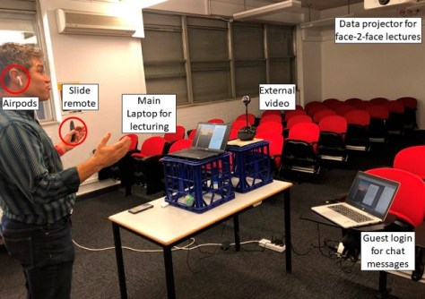
For instance, Mohsen Kalantari presents a vignette of the learning systems used at the University of Melbourne during the COVID pandemic, and student attitudes to virtual and face-to-face instruction methods.
Plus there is an outline of the University of NSW’s rapid switch to online learning, and the innovative ways in which theoretical studies and practical surveying tasks were accomplished.


