


A new, freely available and open-source app that uses aerial survey data to map and identify wild animals, has been launched by researchers from Edith Cowan University.
The app is intended to help researchers and community groups across the world to conduct wildlife imagery surveys.
Known as WISDAM — Wildlife Image Survey Detection and Mapping — the app was co-developed by ECU senior research fellow Dr Amanda Hodgson
“Advanced technology has allowed researchers to shift towards imagery aerial surveys from drones or piloted planes to collect data on wildlife distribution and abundance. These surveys involve collecting photos along survey flight paths and processing them post-survey,” said Dr Hodgson.
“The challenge is now in how to efficiently extract animal detections and other data from the images in a reasonable timeframe.”
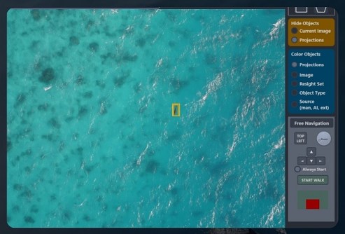
WISDAM is designed to standardise the image review process, enabling users to map the image footprints and detected animals to real-world coordinates and assign information such as species type, age class and habitat details.
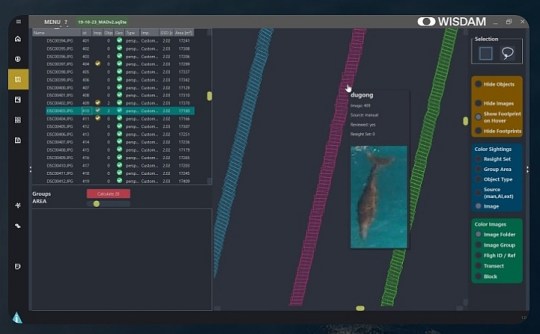
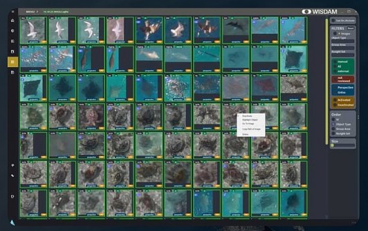
Animals can be detected manually or by using AI models such as the automated Marine Animal Detector that has been developed by Hodgson and her collaborators.
WISDAM has a built-in feature that helps to ensure that individual animals appearing in overlapping images are only counted once.
“We’ve conducted many aerial surveys of marine mammals and have established methods for imagery surveys,” said Dr Hodgson.
“So, we needed one tool that allows us to manage, annotate and map our imagery, and extract all the information that we need from survey images in a standardised way, and that provides outputs we can directly fed into population assessments and spatial modelling.”
“In combination with drones, this tool can help non-experts to carry out surveys in areas where we have little information about animal presence and numbers, and where a lack of expertise and resources has prevented us gaining this knowledge that is critical for helping conservation efforts.”
WISDAM was collaboratively developed with software developer Martin Wieser, Dr Christophe Cleguer from the Marine Megafauna Research Group at the Centre for Tropical Water and Aquatic Ecosystem Research at James Cook University, Dr Nat Kelly with the Australian Antarctic Division, and Dr Frederic Maire from the Queensland University of Technology.


