Multispectral LiDAR

By on 20 March, 2024

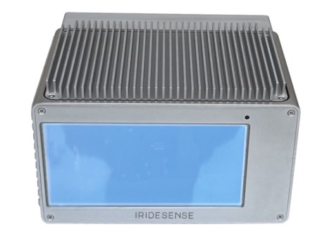
IRIDESENSE has unveiled what it claims is the first 3D multispectral LiDAR sensor capable of analysing plant health and soil humidity levels remotely in real-time, while adding that the unit is also suitable for other applications, such as industrial quality control and forest management.

The long-range (300-metre), 60W 3D LiDAR is based on proprietary SWIR multispectral laser technology, featuring five colours in infrared and high-resolution image quality. The unit can operate completely independent of lighting and meteorological conditions, weighs only 3.5 kg and has dimensions of 142 mm x 220 mm x 192mm.

The company says it is actively searching for partners to deploy the technology to collect data to improve its artificial intelligence.

You may also like to read:


,


Newsletter

Sign up now to stay up to date about all the news from Spatial Source. You will get a newsletter every week with the latest news.

Geospatial in the age of the metaverse
The geospatial sector is set to both underpin the metaverse ...
$140 million allocated for WA Spatial Digital Twin
The 10-year project aims to improve infrastructure delivery,...
March 21: Celebrating Global Surveyors’ Day
March 21 is the day on which we celebrate the essential work...
Government releases new Local Drone Rules map
UAV users can now easily see whether they need to obtain aut...
Photogrammetry with enhanced cloud capabilities
SimActive has announced improved cloud environment enhanceme...