

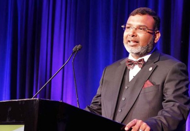
Pictured: Dr Zaffar Sadiq Mohamed-Ghouse has been made an Honorary Fellow of the SSSI.
The SSSI and SIBA| GITA 2020 Asia-Pacific Spatial Excellence Awards were announced on Wednesday, 31 March, during a ceremony at the Locate21 conference.
More than 20 outstanding individuals and groups from across Australasia were recognised for their personal achievements and professional accomplishments in a wide variety of spatial and surveying research work, teaching efforts and projects.
The multi-location online presentation event went off without a hitch, with many participants praising the organisers — and in particular the MC, Melissa Harrington — for overseeing such a successful event.
The following are the winners in each category, along with brief summaries of their award citations. And read on to the end to learn of some very special honours bestowed upon two titans of the industry.
SSSI individual award winners
Professional of the Year Award
Winner: Alistair Byrom
Alistair is Principal Surveyor at Veris in Brisbane, and has served for more than 20 years on committees for ISAQ, SSI, SSSI and SIBA|GITA. His extensive knowledge of land law has resulted in him being called upon to prepare numerous expert reports for various courts. The SSSI award judges noted his consistent contributions to the industry through advocacy, presentations, senior representative roles and in particular his efforts to unify the profession’s voice, making him very worthy of recognition.
Young Professional of the Year Award
Winner: Michael Topp
Michael is the Principal Surveyor for Veris where he uses his depth of experience on multiple projects to guide each from construction to final delivery. He invests heavily in the development of his peers at Veris through mentoring, training and development programs, and has displayed strong technical performance across a range of significant projects in south-east Queensland.
Women’s Leadership Award
Winner: Melissa Harris
Melissa is a leading light in the spatial profession, paving the way for greater diversity within the profession. In 2019, she became the first woman to hold office for ANZLIC in its 34-year history, where, as part of the leadership team, she developed the current ANZLIC Strategy to ensure a diversity of views from industry and academia are included. She is currently Acting Chief Executive of Land Use Victoria and Victorian Registrar of Titles.
Educational Development Award
Winner: Ivana Ivanova
Ivana studied at the Slovak University of Technology and has lectured and conducted research at several universities across three continents. She is currently a senior lecturer at Curtin University, teaching geoinformatics, spatial data quality and distribution, and spatial databases in the Bachelor of Surveying degree, and at a postgraduate level undertakes lectures in the new Geospatial Intelligence courses.
Postgraduate Student Award
Joint winners: Dr W. Boone Law and Antara Dasgupta
Boone commenced his PhD in spatial science and environmental remote sensing at the University of Adelaide in 2015, and since then has used his knowledge and skills to make innovative and well-received academic contributions to Australian archaeology. His PhD is among the first in Australia to promote and utilise advanced aerial and satellite remote sensing technologies to better understand the Aboriginal archaeological record.
Antara has successfully developed a new method for interpreting remotely sensed data in the flood prediction sector, resulting in three publications in top journals. The integration of independent, remotely sensed flood observations from synthetic aperture radar sensors with model predictions has the potential to improve flood forecasts, resulting in greater preparedness and emergency services support.
Undergraduate Student Award
Winner: Alexei Tiong (winner); Highly commended: Daniel Fowler
Alexei’s final year project for his Bachelor of Applied GIS at Flinders University combined his skills in spatial science with those of virtual reality to produce Virtual Flinders, a project that demonstrated how the superior abilities of gaming engines to manage and render 3D data can be utilised to view 3D data captured in the spatial science world.
Daniel’s undergraduate project with UNSW investigated the prevalence of admissions into Liverpool Hospital using a patient’s residential address, focusing on admissions for chest pain. Census data was used to adjust the number of patients in an area based on population density to highlight cluster locations of chest pain. Socio-economic data relating to income and education levels was also used. These methods determined the strength of the relationship between the number of patients and socio-economic status in an area.
Vocational Education Training Student Award
Winner: Russell Commins
Russell personally built and supervised the construction of CORSnet-NSW, the largest single-owner GNSS reference station network in Australia and one of the largest in the world. He refined and implemented a system of negotiation and approvals for effectively converting project planning to project action, and applied heritage, planning and environmental legislation in order to undertake operations in areas of significance.
SSSI President’s Award
Winner: Paul Reed
Paul is a respected licenced surveyor in Queensland, the owner of East Coast Surveys and a member of SSSI since 2014, actively contributing on a number of levels, most recently as Chair of the Queensland Region. In 2019, he became Locate20 Convenor, a role that should have only lasted 12 months until the pandemic changed everyone’s plans. Paul was willing to accept the extension of his term to include Locate21 and was instrumental in shaping the event.
SSSI Eminence Award
Winner: Professor Allison Kealy
Allison is a Professor in Geospatial Science at RMIT University and Research Program Director, Advanced Satellite Systems, Sensors and Intelligence at SmartSat CRC. She is currently President of the International Association of Geodesy, Commission 4 and co-chair of FIG Working Group 5.5 on Multi-Sensor Systems.
Allison has made sustained contributions to advancing the art and science of navigation and promoting and expanding the use of PNT, providing international, interdisciplinary and inter-organisational leadership amongst worldwide science and engineering communities.
SIBA|GITA industry award winners
Award for Technical Excellence Award and the J.K Barrie Award
Winner: 360 Surveying, for Building 22 at the Osborne South Naval Precinct Project
360 Surveying was contracted to undertake high-precision surveying at the Osborne South Naval Precinct for the structural steel wall and roof modules of the largest single span ‘shed’ in the Southern Hemisphere, and only the second building in the world to have been constructed using rotating walls. 360 Surveying was required to monitor the structural movement and accurate placement of the modules during wall rotations and roof lifts, requiring specialised tools and solutions to be developed.
Award for Spatial Enablement
Winner: Brisbane Airport Corporation and Land Solution Australia, for the Brisbane Airport Digital Twin Project
This project has provided the foundation that will spatially enable one of Australia’s busiest transport hubs to become a world-class asset and allow alignment with industry best practice. The project enables data-based decisions and paves the way to transform the way the business operates, using state-of-the-art planning and visualisation with actual 3D spatial data.
Award for People & Community
Winner: Geoscience Australia, Land Information New Zealand and FrontierSI, for the SBAS Test Bed
This project was led by Geoscience Australia in partnership with Land Information New Zealand and FrontierSI, and engaged broadly with industry, academia and government to improve the technological, social and environmental benefits of reliable positioning information. The program was internationally inclusive, and featured projects from across Australia and New Zealand, culminating in the first ever joint procurement of shared satellite infrastructure by both governments.
Award for Innovation & Commercialisation
Winner: Veris Australia, for Rail Runner system
Conceived, designed and built by the Veris team, the innovative Rail Runner is a trolley system that enables the surveying of overhead, suspended and hard-to-access rails. Custom designed to address regular problems confronted by surveyors working on mining assets in the Pilbara region, the project successfully eliminates working-at-height risks and minimises the need to shut down production assets.
Award for Environment & Sustainability
Winner: CSIRO’s Data61 and DELWP’s Forest Fire and Regions and Local Infrastructure Groups, for the Port Phillip Bay Coastal Hazard Assessment
The team co-designed a web-based 4D visualisation and analytics tool to support modelling and communication of coastal hazards in Victoria. The Port Philip Bay Coastal Assessment Hazard Decision Support System integrates 60 hazard layers across a range of sea-level rise scenarios, alongside showcasing DELWP’s historical aerial imagery from as early as the 1930s. The system integrates various modules, 3D buildings and other datasets to allow informed analysis of various hazard scenarios.
SIBA | GITA Chair’s Award
Winner: Lee Hellen
Lee commenced studying surveying in the early 1990s, joining the team at Qasco and travelling to many destinations, including the UK as an engineering surveyor and Darwin as Qasco’s NT Manager. Upon his return to Brisbane he became involved in award-winning projects such as Suncorp Stadium, Chandler Velodrome and Queens Wharf.
Lee then opened his own business, Land Solution Australia, and afterwards joined the then Spatial Queensland Board and played an active role for several years, culminating as Chair. He then joined the SSSI national board, his term finishing last year.
Lee has decided that his focus should span both SSSI and SIBA, and encourages us all to “think globally and act locally”.
Fellowships
Last but not least, there were two other very special announcements made during the presentation ceremony, with high honours being bestowed upon two worthy individuals.
Professor Mark Shortis has been made a Fellow of the SSSI. Mark is a world-leading researcher in high-precision, multi-station and close-range photogrammetry. He has conducted collaborative research with NASA and with universities in Australia, Pakistan and Germany, and has taught spatial and surveying degrees across the world.
Mark is an innovative and passionate teacher, and is well respected by students and peers alike. He has also been a strong supporter of the profession — he was a founding member of SSI, is a past ISP president and has chaired the APRSS and commissions in ISPRS and FIG.
Mark has helped shape the current generation of photogrammetric, spatial and surveying experts, making an outstanding contribution to research and teaching and to the profession.
Finally, Dr Zaffar Sadiq Mohamed-Ghouse was conferred as an Honorary Fellow of the SSSI, the Institute’s most prestigious acknowledgement of service to the industry.
Zaffar is a passionate member, volunteer and valued friend of SSSI, and has been involved in all facets of the Institute. He joined as a PhD student member almost 11 years ago, having previously worked at the Indian Space Research Organisation. He has held numerous SSSI roles including Regional Chair, Commission Vice Chair, National Board member and President from 2018 to 2020. He is currently SSSI’s Company Secretary.
Zaffar has built an extensive professional network and is a member of numerous boards, technical committees and other professional bodies, such as the International Society for Digital Earth, World Geospatial Industry Council and the UNGGIM.
Through his efforts, Zaffar has inspired many and is in large part responsible for the increased growth in SSSI’s membership and its continued stability. He has worked closely with young professionals, inspiring many to become actively involved in the organisation, while also mentoring committee members and volunteers and encouraging them to become involved in representing the profession.
Zaffar has developed a network of relationships, fostering a cohesive and cooperative environment with key stakeholders that has resulted in a number of significant MOUs with notable groups such as the Open Geospatial Consortium, Australasian Hydrographic Society, Association for Geographic Information (UK) and Pacific Geospatial and Surveying Council.
He has also been instrumental in driving new SSSI initiatives (such as the establishment of new Special Interest Groups) and activities to continue providing value and benefit to members and maintaining the Institute’s focus on being the national peak professional body.
Stay up to date by getting stories like this delivered to your inbox.
Sign up to receive our free weekly Spatial Source newsletter.


