

PARTNER FEATURE
A highly affordable GNSS receiver has become a game-changer for those in the utility location business.
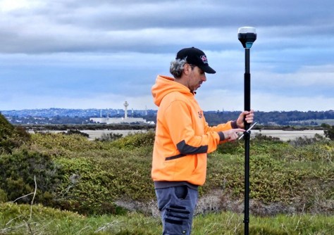
Ben Minutoli is a busy man. As a certified locator and proprietor of Geelong Cable Locations in Victoria, he spends his days doing underground detective work — hunting for buried pipes, wires and other subterranean services. With clients ranging in size from individual households to surveying and infrastructure companies, he’s seen it all when it comes to locating below-ground features.
And it’s important work. Preventing underground electrical cable strikes and pipeline ruptures is crucial, not only for the cost of the damage that can be caused, but also for the safety of workers. That’s why Before You Dig Australia (formerly Dial Before You Dig) fields around 2 million requests for information annually. That’s a lot of digging going on across the country.
It’s why locators such as Ben play such a vital role. Equipped with a ground penetrating radar (GPR) unit, he can scan the ground and see what’s underneath the surface.
“I’ve been doing it for a bit over 20 years now and I love it. I absolutely love what I do,” says Ben.
Traditionally, Ben would paint marks and lines on the ground to indicate where those services are. Then he would have to determine the precise position of those marks and translate them onto a plan or diagram.
Then along came GPS. Ben’s first GPS unit years ago cost $21,000 (for a bottom-of-the-range device) and was very old school. “It had 100-millimetre accuracy when it was working at its best, but most times you would struggle to get that,” says Ben.
Enter Emlid
What’s changed over the last few years is the availability of newer, affordable survey-grade GNSS receivers from Emlid. Emlid receivers are ground-breaking, not just for their affordable pricing but also for their open and flexible approach to working with other equipment and software.
“Receivers like the Reach RS2+ are fantastic in terms of value for money,” says Ben. “The quality you get with Emlid — years ago you would have had to pay $50,000 for. The Emlid Reach RS2+ that I have is under $4,000, and, depending on your requirements, other models such as the Reach RX are even more affordable and compact.”
The flexibility of Emlid receivers enables phones or tablets to be used as survey controllers. They integrate well with other systems, outputting precise positioning to third-party devices such as GPR units using an NMEA string via Bluetooth or serial cable.
Another Emlid user, Anthony Johnstone from pipe and cable locator equipment company Access Detection, sums it up: “Reliable coupling of survey-grade positioning from Emlid receivers into Impulse Radar GPR units, automates precise positioning of GPR logs and drives productivity and precision improvements for us and our customers”.
“Underground service locators are often single-person operations who don’t have deep pockets and can’t invest time in adopting a complex technical solution,” says Alistair Hart, general manager of Map Gear. “Emlid’s Reach family of GNSS receivers are an ideal solution for them. Emlid provides survey accurate positioning with flexible software and simple connectivity — there aren’t even any cables. Just switch it on and off you go.”
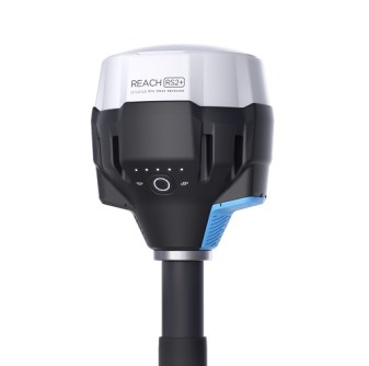
The Emlid Reach RS2+
- Type: RTK GNSS receiver
- Multi-band: GPS/QZSS, GLONASS, BeiDou, Galileo
- Fix: Survey accuracy up to 60 km in RTK, 100 km in PPK
- Storage: 16 GB (160+ days logging at 1 Hz)
- LTE: Built-in, with 2G/3G fallback
- Battery: Up to 22 hours data logging on one charge; up to 16 hours as an LTE rover
Simplified workflow
Another major advantage of the Emlid system is the mobile mapping app, Emlid Flow, which works with iOS and Android devices. Unlike some other manufacturers, who essentially force users to adopt their company’s software, Emlid users are quite at liberty to use other software. But that’s not necessary, according to Ben; Emlid Flow is all he needs.
“What I like about Emlid Flow is how simple it is to use, so user friendly and straightforward,” says Ben. “I can literally walk along the job site and I’ll pick up all the stuff that I’ve located and then export it into CAD. And then I get an aerial image of the site and I’ll import that into the CAD plan and that’s it.”
“I should clarify that we’re not surveyors; I make it very clear to customers that we are not surveyors,” adds Ben. “Back before we had GPS, you’d use a pen and pad, tape measure it all up and come back to the office and draw it all up into CAD. It just took forever. It was slow, it was awkward; I hated it. But that’s what we did because we weren’t surveyors and I couldn’t afford total stations, and a lot of times customers didn’t want to pay for a surveyor to come on site.”
Alistair agrees that the industry needs to open its eyes to possibilities of affordable technologies such as the Emlid Reach family of receivers and hopes to see more locators and contractors moving away from older practices. “I don’t know how many times I’ve seen articles talking about spray-painted survey marks on the ground,” he said. “What happens when the paint is no longer visible — why isn’t all this stuff digital?”
Man on a mission
According to Ben, the RS2+ is so user friendly that even plumbers and electricians should be using it when installing underground electrical cables and pipes. “A lot of these guys have to submit plans to relevant authorities anyway. So we actually do it for a few electricians — they call us out and get us to map where the lines are so that they can then get their compliance.”
As for locators, in Ben’s view every certified locator in Australia should be using the RS2+.
“They can have the higher end stuff, but why? It’s hard enough teaching staff as it is how to use ground penetrating radars and locators and all sorts of stuff,” he says. “With the Emlid there’s very little learning curve. It’s so simple to use and it’s just so affordable too.”
“That’s why I love the gear and why I recommend it to everyone I speak to.”
“Ben is really passionate about improving the professionalism of the locating industry and the value locators deliver to their clients,” adds Alistair. “He’s on a crusade.”
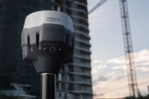
** RS3 model just released **
Emlid has just announced its brand new tilt-corrected RTK GNSS receiver with integrated 450MHz radio receiver, the RS3. Priced competitively at $4,799. For more information visit www.mapgear.com.au.


