

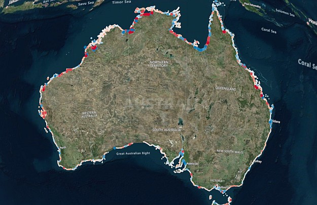
The DEA Coastlines tool combines satellite imagery and tidal modelling to map coastline change. Courtesy Geosciences Australia.
Thirty years of evolution of Australia’s coastline are now accessible through Geoscience Australia’s Digital Earth Australia (DEA) Coastlines online tool.
Drawing on nearly 58,000 measurements of coastline positions, DEA Coastlines combines satellite imagery collected since 1988 with tidal modelling to map the location of the coastline at mean sea level each year.
The tool can be used to reveal long-term trends in coastal erosion and growth, showing how features such as sandbanks or river mouths change over time.
“Australia has a highly dynamic coastline of over 30,000 kilometres with many unique environments: sandy beaches, rocky cliffs, muddy tidal flats, and mangroves,” said Geoscience Australia’s National Earth and Marine Observations Branch Head, Maree Wilson.
“DEA Coastlines is the first nationally consistent dataset within Australia that tracks these changing shorelines.”
“Understanding how our coastal environments have been historically affected by pressures such as extreme weather, sea level rise and human development is vital to managing our coastlines now and into the future.”
Imagery alone is not enough to accurately detail long-term change, as the position of the shoreline is also dependent on the tides… which can rise by up to 11 metres in places such as the Kimberley.
So by including tidal mapping information, DEA Coastlines enables the true coastline boundary to be deduced, providing researchers with a consistent, long-term perspective.
The tool also uses a sub-pixel mapping technique that uses differences in the ‘wetness’ quality of each pixel to extract high-resolution accuracy from lower-resolution satellite imagery.
This makes DEA Coastlines accurate to 10 metres, and able to reveal changes as small as 2.9 metres in certain locations.
“Geoscience Australia worked extensively with local councils, state governments, academia and citizen scientists to ensure the tool will help them reliably assess impacts to our precious coastlines and plan for the future,” Ms Wilson said.
Stay up to date by getting stories like this delivered to your inbox.
Sign up to receive our free weekly Spatial Source newsletter.


