Kiribati, an ocean nation of fewer than 120,000 people, stands on the frontlines of the harshest impacts of climate realities.
Located in the central Pacific Ocean and made up of 33 atolls and reef islands spread across a vast area, it is one of the world’s most geographically dispersed countries.
For Kiribati, maps, of all kinds, are vital, which is why its people continue to fight to rewrite their own story of resilience, innovation, identity, and te aba (the land) from which their roots grow.
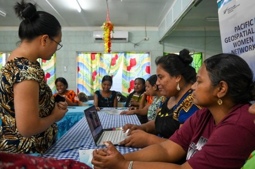
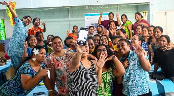
Late last year, the Pacific Geospatial Women’s Network (PGWN) from the Pacific Community (SPC) delivered a week-long training session in Tarawa to a group of women from across the atoll nation, including members of the Kiribati Women in Mapping (KWIM) group.
The program extended beyond technical skill-building. It offered a pathway to digitising heritage, strengthening intergenerational knowledge, and transforming lived experience into spatial data.
Shifting perceptions
The training began with a simple but powerful exercise. The women sketched mental maps of their communities, their gardens, churches, shops, waste disposal sites, and even police posts.
What might appear to some as a mere illustration, to others, the sketches represent memory-scapes. Each line tells the story of how local knowledge is deeply rooted in daily lived experience and represented visual expressions of culture, heritage, and survival.
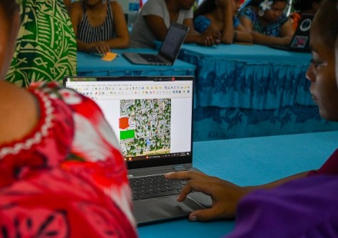
Using the Kobo Toolbox, participants then became data collectors, learning to operate GIS applications such as QGIS to transform their hand-drawn maps into digital layers. What had previously existed as oral or experiential knowledge suddenly took shape as precise, visual records.
“It was interesting to observe that many perceived technology as something complex and hard to appreciate in terms of its benefits,” said Jacqueline Singh, a Technical Assistant with the PGWN team.
“Yet this perception shifted once they saw how smartphones and other everyday devices could be used to collect essential data. What once felt intimidating became a source of empowerment.”
The importance of mapping
Towards the end of the program, it became evident that this was not simply a week of skill development. It marked a turning point for KWIM as the women reflected on national waste management efforts and how geospatial science could support the creation of safer, more sustainable waste disposal sites.
Throughout the event, KWIM members gradually gained confidence in themselves, igniting a spark of hope. Their eagerness to contribute to the wellbeing of their communities impressed national ministries, including Tourism, Cultural Affairs, and Internal Affairs, who were present during the week and acknowledged the training as a game-changer.
Tokanikai Rubetaake, a Senior Tourism officer in Kiribati said that “this is timely for us because it enables our women to take ownership of data collection, and contribute effectively to informing our tourism activities, mapping what could be deemed tourism sites and more.”
“Creating a space where women from all walks of life, whether working in government of private sector, high school students and those that stay at home, to openly discuss existing challenges and share solutions is a big takeaway for most of us,” she added.
For Tiantaake Bauro, an 18-year-old high school student, learning the about GIS and mapping is something she hopes more young women in the island country can have access to.
“This program made me realise the importance of mapping our current resources and identify sites of cultural significance, so we can protect them. If we don’t do this, we risk losing part of our culture and identity,” she said.
The KWIM and the work of other women’s groups in Kiribati will now help inform governance, planning, and decision-making at the national level.
At the core
The training had also become a meeting point for generations, with older women sharing wisdom and younger women translating it into digital form.
Although this was the first PGWN training in Kiribati, the facilitators are confident that KWIM will be the author to capture Kiribati’s story of resilience, written from their perspective as custodians of te aba.
This training week was the third delivery by the PGWN team. The first was delivered in Daku village, in the Central Division of Fiji’s mainland, Viti Levu, and reflected a growing recognition that spatial thinking has become an essential part of modern problem-solving.
Whether analysing climate vulnerabilities, mapping disease outbreaks, GIS now sits at the core of decision-making processes across sectors.
Thus, through mapping, Kiribati women are preserving their heritage and informing national planning, ensuring that their voices shape the future.