Phase 1 S-100 product specifications have entered into force and can be used operationally.
A long-anticipated milestone has been achieved with the new S-100 maritime charting and navigation system, with implementation of the Phase 1 S-100 product specifications.
According to the International Hydrographic Organization (IHO), stakeholders can now access and use the operational version of these specifications in real-world environments.
S-100 enables data interoperability within a single integrated system, connecting the data layers that used by mariners and ocean data users for port logistics, real-time navigation and applications in environmental monitoring.
Unlike the current S-57 standard, S-100 data will be able to be updated in near-real time.
IHO member states and stakeholders can now begin to produce, test and use the operational versions of the following S-100 product specifications:
- S-101: Electronic Navigational Charts (ENCs)
- S-102: Bathymetric Surface
- S-104: Water Level Information
- S-111: Surface Currents
- S-124: Navigational Warnings
- S-128: Catalogue of Nautical Products
- S-129: Under Keel Clearance Management
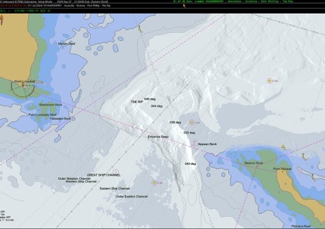
Tory Channel testbed
In advance of the implementation, some IHO member states tested its effectiveness and readiness.
New Zealand performed an S-100 testbed in the Tory Channel, an area known for strong currents and challenging seafloor conditions.
The purpose was to evaluate how S-101 ENCs, S-102 Bathymetric Surface, S-104 Water Level Information and S-111 Surface Currents perform compared to traditional S-57 ENCs in supporting navigational decision-making and situational awareness.
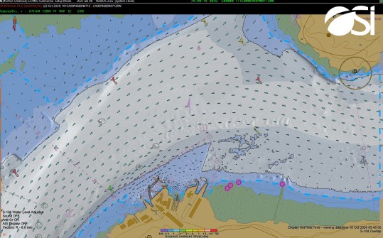
Results for channel areas covered by S-102 Bathymetric Surface showed a 19% improvement in understanding the charted environment during emergency situations, along with a 58% improvement in decision-making support during emergencies.
“The implementation of S-100 for the maritime world is comparable to the early days of smartphones,” said Magnus Wallhagen, Chair of the IHO Hydrographic Services and Standards Committee and National Hydrographer of Sweden.
“At first, these devices seemed unfamiliar and complex, but today, they are almost essential for day-to-day life. We expect a similar progression with S-100.
“As the maritime community gets familiarised with these products, users will increasingly recognise how S-100 can support their work and enhance both safety and efficiency.”