What if your drone could not only do topographic surveys, but also help you model your structure as it’s actually going up?
For construction and engineering professionals who have been using drones on-site, this capability has been out of reach for too long. While drones have proven to be effective at capturing top-down imagery and data, it’s been more difficult to capture data of the side of a building, making the resulting point cloud not nearly detailed as it needs to be for ongoing modelling and as-builts.
UAV innovator, 3DR, set out to fix that, and have announced the result: perimeter scan, 3DR’s newest flight mode in Site Scan Field. Perimeter scan is designed specifically to capture façades and vertical structures, making it easy to collect better data in the field and model projects from start to finish.
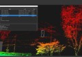
The workflow is simple: first, select the area you want to cover, and Site Scan automatically generates your flight path. The drone flies autonomously at 3 different altitudes and a number of gimbal angles, collecting rich, detailed data.
This helps you create point clouds and meshes that accurately depict taller structures and multi-story buildings. One 3DR customer, Argyle Asia, used the perimeter scan feature for a recent as-built project, and they made their workflow 5X more efficient.
It can also be used to collect volume data on stockpiles, do better inspection surveys for dams and power lines, capture existing conditions for design and renovation projects.
3DR claim that perimeter scan is the first of its kind in the commercial drone industry, enabling construction and engineering professionals to capture a whole new dimension of the jobsite.