Does virtual reality have a place in cadastral applications? UNSW research suggests the answer is a resounding yes.
By Tori Murrant
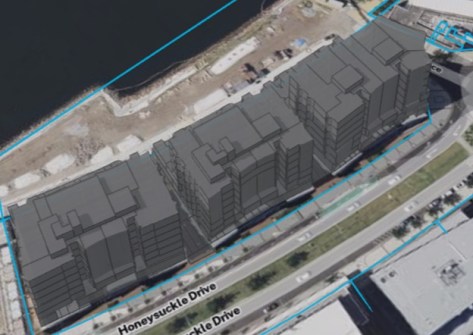
The NSW cadastre is legally three dimensional, representing apartment buildings, mixed-use developments and vertical infrastructure. Yet the official visualisation register, the NSW Digital Cadastral Database (DCDB), represents strata plans only as the two-dimensional extent of the ground-level parent parcel.
In 2024, NSW had a total of 91,078 registered strata schemes, composed of 1.07 million lots. This means that roughly 1.05 million above-ground-level strata parcels across the state are invisible.
The problem with 2D cadastres
A cadastre is a land administration system that records who has rights, restrictions and responsibilities (RRR) for a parcel. For most of its history, this information had been represented in 2D via boundaries on a plan or a 2D visual representation in GIS.
The cadastre consists of vertical RRRs, through strata and stratum plans, or easements and leases. Limiting representation to 2D polygons loses the boundaries between overlapping vertical interests.
This has significant effects for locating parcels accurately and the record of land information. The NSW DCDB is the foundation for many other systems used by government — addressing, land valuation, emergency management, telecommunications, and land use planning and development.
Desktop GIS viewers in 2D and 3D have been the default tool for visualising this data, but usability and prototype research consistently identifies this as a barrier. Navigating overlapping and vertical 3D geometry with a mouse and screen adds friction to interaction, particularly for users without a background in working with 3D data.
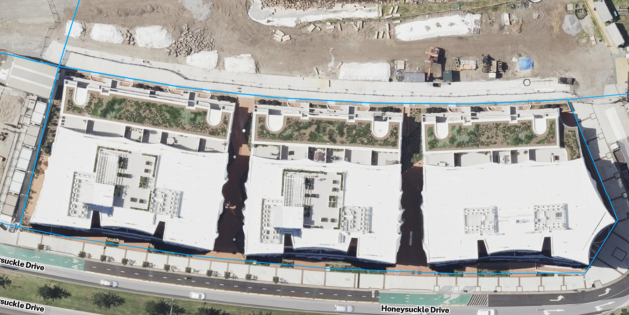
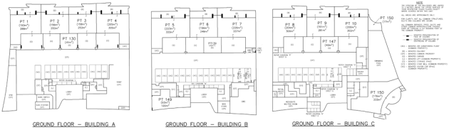
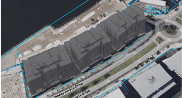
Virtual reality (VR) presents a new spatial paradigm for visualising this data. Rather than looking at a 3D model on a screen, the user stands inside the environment and navigates using their own movement. Prior research on embodied interaction suggests that this can improve spatial understanding.
With this line of thought, the question my research sought to address was whether this technology was usable for the professionals that are the data collectors, custodians and end users of cadastral information.
Building and testing a prototype
The first stage was developing a VR application for visualising strata and stratum plans. Built in Unity, the application mimics the functionality within existing cadastral systems, adapted for use in 3D VR. Users can navigate through the environment, toggle between layers, and query parcel information, using embodied movements or the handheld controller.
To test the application’s usability, structured usability testing was conducted with 43 participants from a wide variety of disciplines — surveyors, planners, GIS professionals, valuers, and land administration specialists. Most of the participants had little-to-no prior experience using VR.
Outcomes and feedback
The results were strongly positive. Participants rated the application above the typical usability benchmark for professional software, with the majority rating it at or above the acceptance threshold, which is notable given how few of them had used VR before.
The qualitative feedback explained these results. The dominant theme was how easy the system was to learn and use. One participant compared the experience to using “an interactive VR Google Maps”. Another said that navigating the strata was “simple and intuitive” and “quick to get familiar with”.
However, the feedback wasn’t all positive. Movement was the most common area that participants highlighted for improvement. There was also an appetite for more data, such as easements, floor plans, and planning information. And some users questioned whether the headset added value compared to screen-based system for everyday tasks.
These points highlighted the role of VR in complementing existing tools rather than replacing them.
Future applications in geospatial
Immersive technology is no longer a novelty and is practical for use in geospatial applications. The results show that the people who would implement this technology can use it.
VR isn’t a replacement for the desktop GIS systems used to manage authoritative data. It’s another tool for communicating complex data and engaging stakeholders. The feedback from participants identified where this application has clear value… the situations where spatial comprehension is a critical aspect of the project:
- Communicate complex cadastral scenarios to stakeholders who don’t look at cadastral data for a living, such as transportation developments (think Sydney Metro or Melbourne Suburban Rail Loop);
- Enabling virtual site visits and revisits for land valuation and planning, reducing the need for repeat inspections; and
- Visualising proposed developments in context before their built to support more informed stakeholder engagement.
A geospatial VR environment facilitates these use cases and highlights the benefits of 3D cadastres and spatial digital twins.
The legal and physical data provided by 3D cadastres are foundational for spatial digital twins as it provides comprehensive information about ownership, planning, and infrastructure. Without this foundation data, a digital twin can show what a building looks like, but not who has rights to any part of it. This is important for enabling use of digital twins beyond just visualisation.
This research adds to the growing body of evidence that immersive technologies are a practical tool for geospatial professionals. The opportunity is now for industry and government to identify where existing workflows and projects can benefit from people being inside the data rather than in front of it.
Tori Murrant is a MPhil candidate at UNSW in the Digital Twin & Land Tenure Engineering Lab, and the GIS Lead at Monteath & Powys. She specialises in integration of GIS, CAD, and BIM, for spatial digital twins. She is passionate about developing innovative solutions that help bridge the gap between surveying, geospatial, and modern digital visualisation techniques.
If you are interested in research collaboration or pursuing a higher degree in this or related areas, you can get in touch with A/Prof Mohsen Kalantari, Leader of the Digital Twin and Land Tenure Engineering Lab.