


Before You Dig Australia’s CEO is on a mission to save lives and protect underground infrastructure from harm.
By Jonathan Nally
Generations of Australians have known of an organisation called Dial Before You Dig, a group of six state-based not-for-profit organisations that enabled anyone from homeowners to infrastructure companies to phone up and find out what was underground before lifting a shovel or firing up a backhoe.
A couple of years ago the entities merged and the name was changed to Before You Dig Australia (BYDA, pronounced BYE-duh) to reflect that the service is now primarily online and because, as CEO Mell Greenall says, “There’s a whole generation out there that’s never even heard of a dial tone”.
Tell us about BYDA and your role in it.
I was brought in to help run the merger of the six state-based Dial Before You Dig businesses. The industry had said it wanted to deal with a single entity, a national organisation that could provide one voice for damage prevention here in Australia. So we ran through that merger process and we officially launched as Before You Dig Australia on the 1st of July in 2022. Our strategy over the next five years is to become the single voice of damage prevention and safe work near utilities here in Australia.
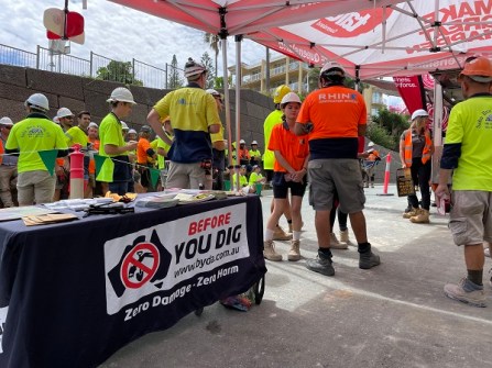
We’re moving much more into online interactive processes, so for us it was really important to have a name that envisioned all of what we do… because we don’t just do the referral service, we do a lot in education and community engagement. We do a lot of work with regulators around safe work practises. Since 1 July 2023 we have delivered about 750 ‘toolbox talks’ around the country with construction crews, council work crews and TAFE students, around risk mitigation when working near utilities.
We’re still a not-for-profit, funded by industry for industry. The utility sector funds us to provide that plan exchange service and then to also now grow into all of the other spaces that we play in. We take our role as a safety partner very seriously not only for the utilities who fund us, but also for the broader industry at large — we process over 10,000 plan requests a day.
Is BYDA mainly focused on subsurface utilities?
Yes, but we’re starting to see a much broader use of the information that we can provide. So for example in Tasmania we do indigenous cultural overlay — if you submit a plan with us, it’ll trigger a response to say that you’re near a culturally sensitive area and there are permit processes you need to go through.
Here in Melbourne, we do ‘trees of significance’ with Melbourne City Council. When people are working, they need to know if a tree is protected so that they don’t damage the root systems. We’re also looking at how we can work with the Queensland Government for fire ant notices. So really our service can provide all sorts of information to ensure people are working safely and efficiently.
There’s also an above-ground infrastructure app called ‘Look Up and Live’ that some of your readers might be familiar with that’s coming to join the BYDA family and become a national tool. We’re just doing the groundwork now to pull it into our ecosystem. So that will then make us the holistic partner for industry, protecting both above- and underground infrastructure Australia-wide.
So where does your location information come from?
The utilities still own all of the data that they send through. When someone lodges a plan request, it’ll trigger an API process to talk to the utilities’ GIS systems and then we pull that data back through. We don’t host any of the data directly.
Some of your readers will remember ‘email hell’. You would do a plan request for inner city Sydney, for example, and you might get 14 emails back from the utilities with 20-odd attachments — upwards of 160 pages of stuff. So in March we launched our collated response viewer — you basically get a link back to the portal and everything’s there on the one screen; a single PDF pack that you can share across team members.
Being reliant on the old school kind of PDF or printable map just doesn’t cut the mustard anymore with the time pressures and the skill shortages the construction sector’s facing. So we do need to work together and with government to provide the appropriate regulatory reform to allow this to happen. One of the barriers is the Security of Critical Infrastructure Act (SOCI) and the foreign Investment Review Board, which has really stalled, if not completely stunted, digital innovation when it comes to location asset plans. Because it’s made industry very, very nervous that they’re going to be in breach of that act if they provide digital asset location.
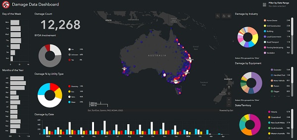
We can see that SOCI was absolutely, genuinely created for a great reason around protecting Australia from cyber terrorism. But the reality is our network integrity is under greater threat every day from the ‘accidental terrorists’ as I call them, on an excavator or shovel, causing damage to the network. For 2023 we’re just collating the third-party strikes, but currently it looks like we’re going to sit at about 20,000 recorded damages to Australia’s infrastructure in one year. And that’s ridiculously underreported — it’s probably only a third of what genuinely went on.
If you use the UK study from Birmingham in 2017 where the ratio is 1 to 29 — so for every dollar spent on a utility repair, it equates to a $29 cost to community — well, in Australia, if I use those stats, that’s nearly a $4 billion problem every year.
If everyone used BYDA, would it eliminate those strikes?
No, things can still go wrong during a job, but absolutely we would see a reduction. Our plans go out at AS5488 quality level D, so it’s the lowest quality plan you’re going to get. But it does indicate the presence of a network, so at least you know you should be then doing further risk assessments, pot holing etc on site.
If I could get those plans to quality level B and we could move to greater digital, particularly for the credentialed construction industry, I think we could reduce strikes by a third because they’d be working off better-quality data from day one.
What can be done about it?
There’s sort of been no real motivator, and this is also one of the challenges around moving to digital — there’s been no real momentum to capture that data better. I say this tongue in cheek, but we’ve normalised inefficiency. We know that there’s fantastic data out there, we’ve got surveyors doing quality drawings, we’ve got as-built engineering drawings for new project work and the kilometres of new infrastructure being laid every day. But generally, those as-builts, those engineering drawings, don’t make it back to the utilities to get up updated in their system. There’s no impetus to require it. And also AS5488, which we so heavily rely on for our utility planning and mark-ups, doesn’t quite cover the use of third party or digital data. So it needs to be updated to recognise that we’re moving into a more digital environment.
We need to create an environment of sharing, a circular economy of the information that’s being generated and make sure that it can be fed back through to the utility GIS systems, and then making sure that we can then push that out through the BYDA server so that over time we can lift the quality of the plans and support safer outcomes out on job sites.
Do digital twins have a role to play?
I do think BYDA has the capacity to grow to be that digital twin for the utility infrastructure in Australia. But the issue we have here is the regulatory reform piece — when we have tensions between federal acts sitting over the top that are prohibiting digital innovation and the ability to grow that digital twin, we’re never going to get there. We need to find a way to recognise that our construction sector deserves better and we should be supporting them, particularly when every Minister in this country at the moment is talking about productivity gains, inflationary costs, supply chain issues and skill shortages.
Yet here we are, still forcing this circular economy of inefficiency when it comes to project planning around utilities. So we need to do better, and I genuinely believe it is going to take a government approach to support us to get there. And that’s then going to require supporting the utilities to fund and resource the uplift in the quality of their utility infrastructure GIS plans and then educate the construction sector. That’s also going to mean a common schematic across the country — we have 700 utility members and I’ll guarantee you they’re all using 700 different versions of base maps.
But there are some excellent examples. In New Zealand, the City of Wellington has done a digital twin and it’s fantastic. The credentialed construction sector can jump in and look at the utility plans for road repairs, road installations etc. So it can be done. We just need to create the environment for Australia to keep up.


