

Here’s what you’ll find in the Feb/Mar 2024 issue of Position magazine, Australia’s geospatial sector journal covering the spatial, surveying, space, UAV, remote sensing, hydrography and mapping sectors and more.
If you’re already a subscriber, keep an eye out for your copy in your letterbox any day now.
If you’re not already a subscriber, please head to our subscription page and sign up today to stay fully informed of developments in the Australasian geospatial sector.
Inside you’ll find:
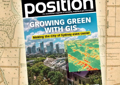
- COVER STORY: A greener, cooler Sydney — Find out how the City of Sydney has set ambitious targets to grow a cooler, more diverse and resilient city using mapping technology.
- Meet the metaverse — Learn how the geospatial sector is set to both underpin the metaverse and capitalise on the opportunities it presents.
- Mapmaking for a better world — The International Cartographic Association is on a mission to support cartographic R&D, education and knowledge dissemination.
- Landsat 2030 — The Landsat 2030 International Partnership Initiative will take advantage of the new capabilities of the Landsat Next triple-satellite mission to manage land, surface water and resource use.
- Homegrown hyperspectral — The Australian CyanoSat satellite’s novel imaging system is designed to spot dangerous algal outbreaks from orbit.
- 3D laser scanning — The new RIEGL VZ-600i 3D terrestrial laser scanner is making an impact with its speed and versatility.
- Surveying history — Almost two centuries of Queensland’s surveying history are maintained and displayed at the Museum of Lands, Mapping and Surveying.
- Simple solution — Kurloo, a transformational Australian-designed displacement monitoring technology, is enabling new business opportunities for surveyors and engineers.
- Geography strategy — The UK’s new Geography Profession Strategy sets out three pillars of activity that will enhance the profession’s influence within the government.
- Money for geodesy — Four projects worth up to US$20 million will address key issues facing the United States’ geodetic community.
- Environmental challenge — An international mapping and humanitarian engineering project in Indonesia’s Gili Islands is tackling community needs.
- Unriddling RINEX — Take refresher course on the history, philosophy and benefits of RINEX for the storage and exchange of GNSS data.
- Metrication memories — It is now 50 years since surveying went metric in Australia; Tony Proust looks back to what things were like in 1974.
This issue also contains the latest updates from the Geospatial Council of Australia (GCA):
- CEO’s Column — Tony Wheeler takes an in-depth look at the preliminary proposed changes to ANZSCO recognition of the geospatial professions.
- Beyond trophies — Learn how to capitalise on the business benefits of industry awards programs.
- From sea to boardroom — Get to know Stewart Dunne, former Hydrographer of Australia and the GCA board’s newest independent non-executive director.
Plus all the latest industry news, a full list of upcoming conferences and details of the latest products on the market.
Stay up to date with developments in the Australian surveying, space and spatial sectors — sign up today to receive Position magazine by heading to our subscription page.


