

Preliminary findings from a new economic study show that geospatial information and services could contribute an additional $81 billion to the Australian GDP by 2033–34.
That headline figure and other findings from the Geospatial Council of Australia’s (GCA) ‘Economic impact of geospatial services in Australia’ report were presented last week at Locate, GCA’s annual national geospatial conference.
The economic analysis, the first of its kind since 2008, was commissioned by GCA and carried out by a team from ACIL Allen.
Two key findings are that:
- In the current 2023–24 financial year, the geospatial sector will contribute $39 billion to Australia’s GDP along with more than 12,000 jobs.
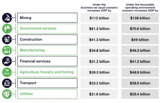
- By 2033-34, it is projected that the GDP contribution could be an additional $81 billion with an additional 22,000 jobs, assuming a favourable operating scenario.
According to the report’s authors, these forward-looking projections can be considered conservative as the analysis has yet to include the contribution from digital twins.

The authors also point out that some economic contributions of the geospatial sector can be difficult to quantify and monetise, but are illustrated by a series of case studies that show how geospatial services add value across the Australian economy.
“The geospatial sector is critical to the economy. Few, if any, industry sectors are not using geospatial technologies in their operations,” said Tony Wheeler, CEO of GCA.
“By understanding where we stand today and envisioning our potential influence on the national economy over the next decade, we are shaping policies that will not only foster growth but also position the geospatial sector at the heart of Australia’s broader narrative.”
The full report will be released at the end of June.


