

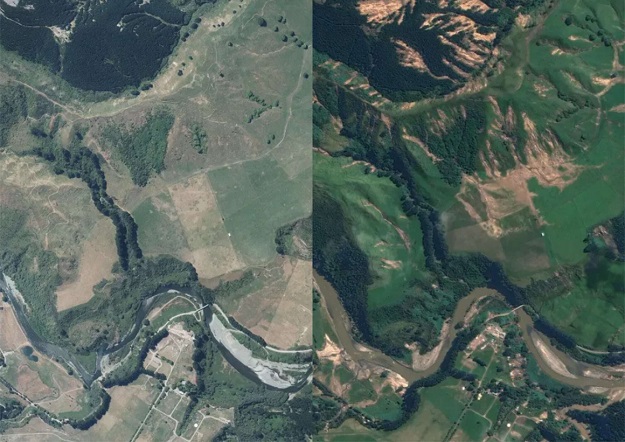
The image on the left shows the area around Mohaka River, Te Haroto, before Cyclone Gabrielle. The image on the right is the same area captured shortly after the cyclone, showing landslips and flood damage. Image credit: LINZ Basemaps.
New high-resolution satellite imagery providing a birds-eye view of Cyclone Gabrielle’s impact on New Zealand’s North Island’s east coast is now available online as part of the emergency response.
The satellite imagery covers about one-third of the North Island and is available to the public via the Toitū Te Whenua Land Information New Zealand (LINZ) Basemaps and LINZ Data Service online platforms. It provides detailed, post-cyclone imagery of the Hawke’s Bay, Tairāwhiti and Tararua districts.
Basemaps: North Island 0.5m Cyclone Gabrielle Satellite Imagery (21 February 2023)
LINZ Data Service: North Island 0.5m Cyclone Gabrielle Satellite Imagery (2023)
LINZ worked closely with the Ministry for Primary Industries (MPI), Hawke’s Bay Regional and Gisborne District councils, and the National Emergency Management Agency (NEMA) to understand which data would be most useful to cyclone recovery efforts. The resulting satellite imagery was taken shortly after the cyclone, showing the impact of flooding and landslides.
“Being able to see cyclone-hit areas in great detail is useful for those involved in the response and recovery — such as local and central government agencies, farmers, community groups and industry boards,” said LINZ Head of Location Information, Aaron Jordan.
“Users can zoom in to see detailed pictures of how flooding caused by Cyclone Gabrielle has impacted local infrastructure such as houses, roads and communities. Analysing this information helps with making decisions.
“Collecting, maintaining and sharing land information is our core business and we’re pleased to be able to support affected communities in this way as they recover from this devastating weather event.”
MPI Director of Forestry Insights, Debbie Ward, said the imagery will provide vital information to enable detailed assessment of the damage.
“It will be useful for multiple agencies both in the recovery from Cyclone Gabrielle and also modelling for future risks and mitigation,” she says.


