The National Land Survey of Finland (NLS) has released a new geoid model which, it says, represents the shape of Earth with 30% more accuracy than the previous model.
Previously, Finland’s official geoid model was FIN2005N00, which had an accuracy of 2 cm. The accuracy of the new FIN2023N2000 model is 1.4 cm.
“The requirements for the accuracy of geospatial data are constantly increasing. The new geoid model better responds to modern requirements for the accuracy of geospatial data,” said Mirjam Bilker-Koivula, Group Research Manager at the Finnish Geospatial Research Institute (FGI) of the NLS.
The NLS has participated in BSCD2000, the Baltic Sea geoid model developed in international cooperation, which responds to the needs of shipping and nautical chart makers. FIN2023N2000 has been adapted to sea areas so that it is compatible with the new Baltic Sea model.
The NLS’s geoid model is based on years of hard work in geodesy research.
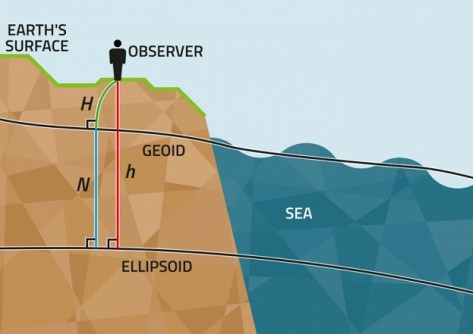
“In the north, tectonic uplift changes and distorts elevations, coordinates and gravity values. The geoid model needs to be updated to provide society with the most accurate and up-to-date elevation data,” said Senior Research Scientist Timo Saari.
The previous model was used for more than ten years. During that time, researchers gained access to new datasets and methods that have been used in the new model.
“In my doctoral dissertation, I studied the impact of gravity satellites and marine gravimetry on geoid modelling. The new model includes the datasets of the GOCE and GRACE satellite missions and the Gulf of Finland marine gravimetry campaign, which improve Finland’s geoid model both nationally and locally,” said Saari.
The soon-to-end GeoVaPaa project funded by the country’s Ministry of Forestry and Agriculture investigates what impact the resolution and accuracy of the gravity dataset has on the accuracy of the geoid model in Finland, and whether the current gravity dataset meets the accuracy and resolution requirements set for the geoid model of the future.
“The new geoid model offers the highest possible level of accuracy that can be achieved using current datasets. The geoid model was updated using gravity satellites, the elevation model based on national laser scanning, the harmonisation of gravity data, gravity measurements at sea, and the new GPS levelling dataset,” said Bilker-Koivula.