Mining and engineering surveying software

By on 25 July, 2024
Maptek GeoSpatial Manager

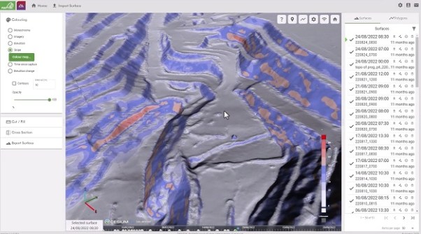
Maptek has released its GeoSpatial Manager software for mining and civil engineering users, which handles data from laser scans and drones and connects those users to real-time updates for surveyed surfaces.

Smart visualisation tools enable the user to interact with as-built surfaces, enabling collaboration and accessibility for all project teams within an organisation through a web interface.

GeoSpatial Manager automatically updates as-built surfaces when new data is imported, with centralised storage on a cloud or network server helping to avoid uncertainty around locating survey files that may be stored in various folders on a local or server machine.

You may also like to read:


, , , ,


Newsletter

Sign up now to stay up to date about all the news from Spatial Source. You will get a newsletter every week with the latest news.

Q&A with Zaffar Sadiq Mohamed-Ghouse
Combatting climate change, saving lives and building better ...
Satellite imagery helps coastal data collection
A new study highlights the accuracy of satellite-derived bat...
Geospatial in School Awards recipients announced
Two outstanding teachers and a high school student have been...
The geospatial reality capture revolution
Aptella’s solutions are transforming spatial data and revo...
Evolution in survey: XGRIDS and Gaussian splats
Using 3DGS and SLAM technology, XGRIDS bridges the gap betwe...
Emlid joins Esri’s global Partner Network
The move will enable Esri ArcGIS users to take advantage of ...