Firefighters, landowners and public authorities in California now have an easy way to monitor the location and spread of wildfires and other natural disasters.
Esri has joined forces with the University of California San Diego’s ALERTCalifornia program to launch an ArcGIS map layer that provides real-time access to the feed from a network of cameras across the state.
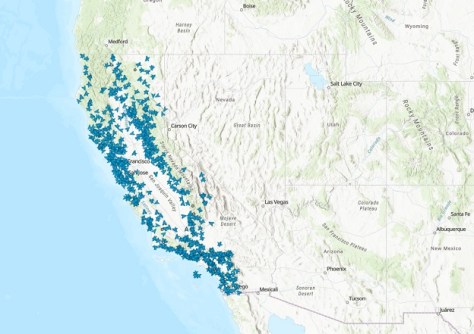
The free layer within the ArcGIS Living Atlas of the World provides access to more than 1,150 high-definition, pan-tilt-zoom cameras and sensor arrays within ALERTCalifornia’s network.
The layer shows each camera’s location, real-time viewshed (the area visible from each location), plus the camera’s current image.
Users can incorporate the feeds into their own maps and dashboards, directly within ArcGIS.
“Firefighters in California rely on real-time data to enhance situational awareness and make informed decisions during all-hazard incidents,” said Zachary Wells, ALERTCalifornia deputy director of operations and deputy chief at Kern County Fire Department.
“Integrating ALERTCalifornia data into Esri Living Atlas will increase firefighters’ access to imagery across various applications and platforms they’ve integrated into their daily operations.”
The cameras provide imagery that is updated every 15 seconds and can perform 360-degree sweeps. They are capable of viewing out to as far as 100 kilometres on a clear day and 200 kilometres on a clear night and combine the real-time data with AI to detect smoke and other anomalies.
“During events, our array of cameras and sensors provide confirmation of ignition, actionable real-time data to quickly scale fire resources, help evacuations through enhanced situational awareness, and monitor fire behaviour,” said Neal Driscoll, ALERTCalifornia director and geoscientist at Scripps Institution of Oceanography at UC San Diego.
“These sensors are new tools in the toolbox that allow data to drive firefighting decisions.”