Australian company Geospatial Intelligence and Canadian firm EarthDaily have announced an Earth observation partnership.
The collaboration will see EarthDaily’s science-grade Earth observation data and analytics made available for Geospatial Intelligence’s customers across Australia.
The company currently has seven satellites in orbit, with its 10-spacecraft constellation due for completion in the second half of 2026.
Canberra-based Geospatial Intelligence has a range of clients, but a strong focus on government users across sectors such as defence, security and the environment.
“The world doesn’t need more imagery. It needs trusted, consistent measurement,” said Don Osborne, CEO of EarthDaily.
“With each satellite we bring online, we are closing the gap between data collection and decision-making, delivering the foundation for AI-ready geospatial intelligence at scale.”

EarthDaily’s high processing capacity
The satellite company was founded in 2021 and launched its first satellite (EDC-01) last year, with six more (EDC-02 to EDC-07) following on earlier this month. Its first high-resolution images were released in March.
“Most Earth observation systems were built to capture images,” said Osborne.
“We built EarthDaily to measure change. With this second launch and successful contact across multiple satellites, we are moving quickly toward delivering a consistent, daily understanding of the planet that customers can rely on to act with confidence.”
The company claims that its spacecraft have one of the highest pixel-processing capacities in orbit, able to digitise more than 20 billion pixels per second.
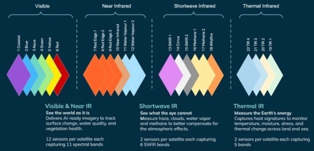
Each satellite carries 16 multispectral imagers — 12 visible and near infrared imagers (VNIR), two short wave infrared imagers (SWIR), and two thermal infrared imagers (LWIR) — plus visible spectrum capabilities (RGB), for a total spectral range of 22 bands.
The company also claims that it is the first operator of a commercial Earth observation satellite constellation to have achieved CEOS Analysis Ready Data compliance.