


New geospatial tech company Terria has been spun out of the CSIRO following the closure of a seed investment round with Australian tech investment fund, Main Sequence.
Terria says the seed funding will help support its global ambitions, with the company clearly having its eyes on the predicted $50 billion growth in the geospatial data market over the next three years alone.
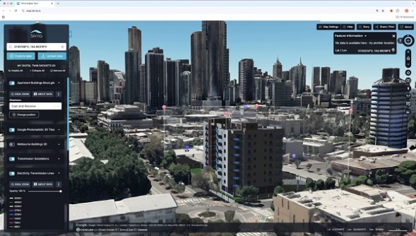
The company has developed technology to create spatial digital twins by organising and visualising spatial data across thousands of mapping and information layers.
The business is being led by two former CSIRO employees: Ana Belgun, who has been appointed Chief Executive Officer and Product Lead, and Amber Standley, who has been appointed Chief Experience Officer.
“Terria started in 2014, when the first open-data, open-source Australian Government platforms were created to help any organisation or individual to access and visualise spatial data,” Ms Belgun said. “Since then, millions of users have accessed over 15,000 datasets on Terria mapping platforms.
“In this next phase we will scale the positive impact we have created so far for Australian companies and government agencies and take these advanced tools global to enable the creation and management of digital twins across different domains.”
Professor Elanor Huntington, CSIRO’s Digital, National Facilities and Collections Executive Director, said the national science agency was proud to have incubated Australia’s newest tech start-up.
“It is very exciting to watch research turn into technology with real-world impact, and in this case, to form the foundation of a new stand-alone company,” Professor Huntington said.
“We are extremely proud of the Terria team — geospatial visualisation makes the enormous amount of global data understandable and accessible for everyone.”
Mike Nicholls, Partner at Main Sequence, said “We first saw Terria a few years ago in the CSIRO Data61 lab and loved the products and how they were being adopted by users”.
“A typical city street has thousands of data sets and plans for buildings, streets, footpaths, electricity, water, sewage, telecommunications, parks, stations, transport, planning and the natural environment,” he added.
“Terria can bring all that data together integrating 80 different formats and visualise this on one map. We are excited to help spin this company out and look forward to them growing a huge customer base over the coming years.”


