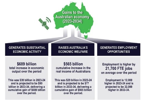
Australia’s economy could be better off to the tune of a cumulative $689 billion over the next 10 years thanks to continued uptake of geospatial technology.
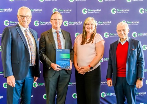
The figure is contained in a new report, ‘Economic Impact of Geospatial Services in Australia,’ commissioned by the Geospatial Council of Australia (GCA) and officially launched at Parliament House in Canberra.
The report outlines the vital role geospatial data and technology have in boosting economic activity and driving social initiatives across a wide range of sectors.
The report, which took 12 months to complete and is the first of its kind published in Australia since 2008, was prepared by an expert team led by Alan Smart from ACIL Allen.
Dr James Johnson, CEO of Geoscience Australia, who received the report on behalf of the government, said that it will “be a very useful evidence base for industry advocacy to policymakers, and for motivating investment decisions for government entities”.
“It’s crucial that we consider how we can proactively shift the dial to enable geospatial data to drive innovation, improve decision making and enhance productivity across various sectors,” he added.
“The report highlights our dependence on several factors, including digital and data frameworks, linkages with adjacent parts of the economic ecosystem, enhancing technologies and systems, innovation, and building professional communities.”
The report outlines how the efficient use of modern geospatial data and technologies can boost Australia’s national economic performance, finding that it contributed $39 billion and 12,000 full-time equivalent jobs to the economy in the 2023–24 financial year and estimating that to increase to as much as $90 billion per year by 2033–34, along with an additional 32,000 full-time jobs.


Tony Wheeler, CEO of the GCA, said that the organisation “initiated this study and analysis to highlight just how important geospatial information and technology is to our nation’s economy and society in general. We felt it was really important to have a strong evidence base to support our advocacy”.
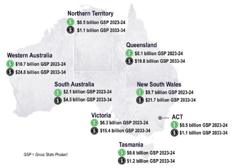
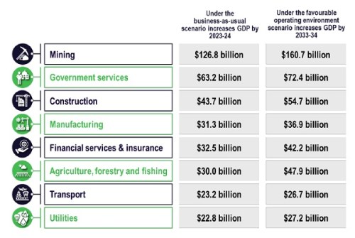
As well as the economic data — broken down by state and industry sector — the report also lists 167 relevant geospatial case studies from around the country and presents full details on 65 of them, in fields ranging from mining to transport, and the environment to farming.
Kate Lundy, Chair of the GCA, said that, “Together, these case studies give the most prescient illustration of the relevance to our day-to-day lives, of our professional endeavours, our industrial endeavours, and our national strategic interests right across Australia.”
“Every one of us uses this information on a daily basis. However, it’s true to say that the general public is often unaware of the depth and relevance of geospatial in their lives,” she added.
“This report aims to re-adjust that perception. It seeks to bring to the fore a greater understanding of that relevance and status of an important technology family, of services and technologies that relate to geospatial and all of the other technologies that sit within that.
“The goal is to enable the sector to provide further productivity gains to the benefit of all Australians. But to do that, we need to build that collective understanding of that greater relevance.”

In response to a question from Spatial Source regarding how the geospatial workforce shortage issue plays into the ‘favourable outcome’ scenario presented in the report, ACIL Allen’s Alan Smart said that this “is a really important point, because there are shortages of technical skills across the board”.
“One of the issues for geospatial is, as a term, [it] is not in the national [occupations] criteria or some of the state criteria,” he said. “So, there are some real issues here for the Geospatial Council and others, and the industry, to work through to try and get priority [for geospatial as an occupation]. Maybe we have to piggyback off IT or construction. But there are TAFE priorities, and at the moment not all of them are meeting the geospatial requirements.”
In answer to a question about how climate change and mitigation strategies factor into the report, Smart said that “Every state is using it [geospatial] to map and monitor climate change. The federal government uses it to record and monitor emissions. And more importantly, governments are now using it to understand where the critical points are and how they’re going to plan and respond to the effects of climate change.”
Smart used the Victorian Department of Transport as an example, describing how it is using geospatial information for understanding where the climate change risks are for the rail system, so that it can plan for any impacts on operations.
The report and its companion case study volume are available for free download.
Production of the report was supported by leading Australian companies and organisations: The Surveyors’ Trust, ANZLIC, ICSM, FrontierSI, Esri Australia, Nearmap, Woolpert, Goescape, Jacobs, Spatial Vision, Geoscience Australia, Land Surveys and Aptella.


