New flight app and a cloud-based platform allow for automated inspections and asset management
Pix4D, the industry leader in drone-mapping and photogrammetry software, launches Pix4Dscan and Pix4Dinspect. The flight app and a cloud-based software solution are equipped with industry-specific tools and artificial intelligence to deliver an end-to-end solution for industrial inspections and asset management.
Asset inspection and maintenance represent the biggest costs during an asset’s lifetime, and traditional inspection processes are risky and time-consuming, both in the field and at the office.
 In the field, manual data acquisition is already being replaced by drones, as they make operations faster and more cost-effective. But drone flights around infrastructure are complex, and the data needs to be accurate and actionable.
At the office, visual inspection may be even more difficult, as it requires visualizing, analyzing, annotating and reporting hundreds of images. Over time, this process generates massive amounts of data, which is difficult to organize, review and manage.
Pix4D, the industry leader in drone-mapping and photogrammetry software, launches Pix4Dscan and Pix4Dinspect. The flight app and a cloud-based software solution are equipped with industry-specific tools and artificial intelligence to deliver an end-to-end solution for industrial inspections and asset management.
 Asset inspection and maintenance represent the biggest costs during an asset’s lifetime, and traditional inspection processes are risky and time-consuming, both in the field and at the office.
In the field, manual data acquisition is already being replaced by drones, as they make operations faster and more cost-effective. But drone flights around infrastructure are complex, and the data needs to be accurate and actionable.
At the office, visual inspection may be even more difficult, as it requires visualizing, analyzing, annotating and reporting hundreds of images. Over time, this process generates massive amounts of data, which is difficult to organize, review and manage.
Pix4Dscan and Pix4Dinspect have been designed in response to these needs, as an end-to-end solution for asset visual inspection and management.
Pix4Dscan is a professional asset flight app developed by photogrammetry experts for visual inspection experts.
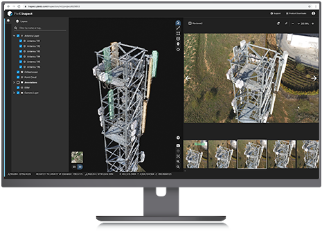
Pix4Dinspect is cloud-based software generating 3D models and offering asset management capabilities for professionals in the infrastructure sector.
“Pix4Dinspect is built on unique machine learning capabilities for automatic measurements and extraction of valuable information from images,” comments Alexis Castilla, Head of Product Development. “We have started with algorithms for the telecommunications industry, but as an innovative software company, we will continue developing artificial intelligence capabilities to meet the needs of other verticals.”
 Inspection companies and asset owners have also expressed the need for managing all the data generated by inspections, for having more control over their assets and maximizing their return. Along this line, Pablo Santos, Business Strategy Manager at Pix4D, adds “Pix4Dinspect ´s mission is to make visual inspections automatic and making data accessible, shareable and secure while reducing the number of images to be reviewed. The real value Pix4Dinspect offers is bringing industry-specific tools and AI algorithms to both your digital twin and your inspection, thanks to Pix4D’s expertise in photogrammetry.”
Pix4Dscan and Pix4Dinspect are available for purchase starting today by contacting the Pix4D sales team.
About Pix4D
Pix4D (pix4d.com) develops cutting-edge software that converts images taken by hand, by drone or by plane into accurate and georeferenced survey-grade 2D mosaics, 3D models and point clouds. The dynamic and rapidly expanding company, founded in 2011, is based in Switzerland, with offices in San Francisco, Denver, Shanghai, Berlin, Madrid and Tokyo.
Information provided by Pix4D