ComNav Marine have made the collection of field position analysis data very easy for geomatic, survey, machine control, construction, mining, agriculture, automated guidance vehicles and many other High Precision applications.
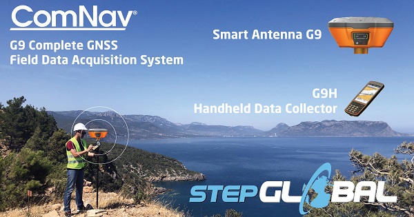
The ComNav system consists of the G9 smart antenna, the G9H handheld datalogger, and post processing office software.
The G9 Smart Antenna is a state-of-the-art multi frequency multi constellation survey grade GNSS RTK receiver. This precise positioning intelligent receiver is user configurable to operate either as a precise Base Station or to operate as a Rover in a network. The unit comes in a compact industrial grade package designed for rugged lightweight universal applications.
 The G9 encompasses multiple wireless communication ports, including WiFi and Bluetooth, with an embedded UHF SATEL radio along with a 4G internal cellular modem for worldwide coverage to receive correction data. The device can be configured via web user interface to control functions, manage data collections, or conduct easy firmware upgrades.
The G9 features fast start-up and signal re-acquisition times, heading & position updates up to 50 times per second, coupled with onboard high-speed memory storage up to 32 GB. The G9 is a complete Smart Antenna in a single rugged, marine-grade enclosure engineered for the most demanding environment applications.
The G9 provides world class centimetre level accuracy RTK corrected precise positioning. The units are tested to perform in multi-faceted open sky applications, with long base lines, and optimal for use in applications such as marine, land, survey, dredging, GIS, engineering, research, scientific, engineering, machine control, agricultural, USVs, and many other specialized situations demanding precise positioning.
It needs only one single power/data cable routing, which greatly simplifies installation or for mobile portable applications, the unit is embedded with a rechargeable 10,200 mAh Li-Ion battery capacity (up to 12 hours Rover operation), designed for ease of use for GIS, survey and construction work.
The G9H handheld data collector is a rugged, 5.5” AMOLED display with internal GPS, MEMs sensor, LTE, Wi-Fi and Bluetooth connectivity. The G9H runs the LandStar 7 App, a fully featured and intuitive field data collection App designed for High Precision surveying, engineering, hydrography, mapping, GIS data collection, road stakeout and pipeline surveying.
The G9H supports OSM/BING online maps as well as base map formats such as DXF, SHP, TIF, SIT, KML, KMZ and WMS when surveying. During data collection, users can customise attribute fields with media capture (pictures, videos and voice). The G9H is expert at Road Functions and Pipeline Survey. Features include horizontal and vertical alignment, cross-sections with slopes and user defined structures. Users can input/import designed road elements from LandXML files and select polyline from DXF files as the centre line to stake out or survey the cross road.
Back in the office, surveyors can use the ComNav Geomatic Office Software 2.0 to process GNSS data with static, PPK and PPP algorithms. This post processing software supports all frequencies on GPS, GLONASS, Beidou, and Galileo constellations. It handles multiple file formats; RINEX, .HCN, .NOV, .BD9. Runs on Windows 7 or later operating systems.
Step Global has the broadest range of High Precision modules and systems from manufactures such as Trimble, Harxon, ComNav Marine and complemented with a huge range of precision antennas from PCTel and Maxtena.
To find out more about the ComNav G9, Complete GNSS Field Data Acquisition System, and for all other High Precision needs, get in touch with the experts at Step Global.
 E: sales@stepglobal.com
W: shop.stepglobal.com
T: +613 9551 7334 Mon-Fri 9am-5pm aest
Step Global
Unit 7, 444 Warrigal Road
Heatherton, Vic, 3202