Aptella’s reality capture solutions are transforming spatial data and revolutionising workflows in profound ways.
PARTNER FEATURE
From sprawling mine sites to intricate architectural details, the digital transformation of our physical world through reality capture technology is transforming how spatial professionals collect, analyse, and utilise environmental data.
Aptella stands at the forefront of this digital revolution, offering an extensive spectrum of reality capture solutions tailored to diverse applications across multiple industries.
Bridging the physical and digital realms
Reality capture — the process of scanning physical environments to create digital twins — has evolved dramatically in recent years. What was once a specialised, expensive technology has become increasingly accessible, precise and versatile. Aptella’s comprehensive suite of solutions reflects this ever-changing industry, providing options that range from lightweight mobile scanning systems to advanced aerial platforms.
“We’re seeing unprecedented demand across sectors, from traditional surveying applications to cutting-edge visualisation projects,” says Geoff Preece, Market Development Manager with Aptella. “The common thread is the need for accurate, reliable data capture that can be efficiently transformed into actionable insights for our customers.”
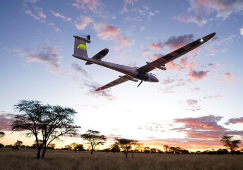
The applications are remarkably diverse. For a 10km highway redesign, an RPAS solution like the Trinity Pro from Quantum Systems might be ideal. For reconfiguring an industrial factory’s interior layout, terrestrial scanning systems such as the MLX or VLX from NavVis would be the method of choice. Of course, complex projects often require combining both approaches — capturing a factory’s exterior and surrounding land with RPAS, while documenting interior spaces with precision scanners for the very best results, first time.
Aptella’s cutting-edge reality capture arsenal
Aptella offers a comprehensive suite of reality capture technologies, including exclusive and complementary solutions:
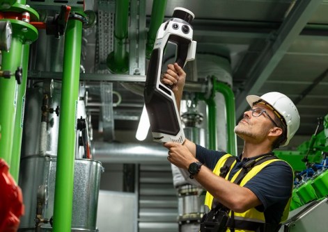
- MLX (NavVis): A cutting-edge handheld scanning solution launched in October last year.
- VLX (NavVis): Advanced mobile mapping technology.
- Trinity Pro (Quantum Systems): Sophisticated RPAS platform.
- HubX: Integrated data management solution.
- XGrids: An exciting new scanning technology.
- Enterprise survey-grade DJI drone platforms.
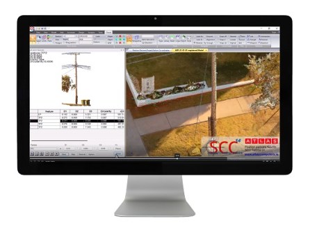
Aptella’s reality capture portfolio addresses the full spectrum of industry needs, with particularly transformative impacts in cadastral surveying. For these professionals, the integration of point clouds with traditional survey control has revolutionised workflows in profound ways. By combining high-density LiDAR scanning with precise GNSS positioning and inertial measurement, these systems create georeferenced point clouds that complement traditional survey methods rather than replacing them.
This hybrid approach dramatically reduces time spent in the field while simultaneously enhancing deliverables with rich contextual data that traditional methods alone cannot provide. The result is a more efficient process that maintains the exacting standards required for cadastral work while introducing new dimensions of spatial information.
Driving AEC adoption of MLX NavVis and VLX
A growing trend in the AEC industry sees architects, engineers and consultants investing in MLX NavVis to capture their own spatial data. This shift allows professionals to have greater control over their projects, eliminating complete reliance on external surveyors.
“A couple of architects on the Sunshine Coast of Queensland have vertically integrated their business by investing in NavVis VLX and NavVis Ivion technology to capture their own data rather than outsourcing. This gives them the advantage of controlling data from collection to model, streamlining their workflow and reducing project delays,” says Preece.

The newly refined Ivion Go app is revolutionising how users interact with NavVis data. “Once you use an NavVis MLX to digitise a site — say, a train station — any rail employee with the free app can walk through, take photos of defects, add notes, and upload the data instantly. Because the app spatially locates the user, stakeholders can immediately see the issue, exactly where it is, and act on it,” says Preece.
The Ivion Go app, released in the past six months, is a powerful tool for asset management and facility maintenance, providing service providers with a valuable resource for their clients.
The latest technology edge
While point clouds remain the foundational data type for many applications, advanced rendering technologies are expanding the utility of reality capture data. One particularly promising development is Gaussian Splatting, an innovative algorithm that represents 3D scenes as a collection of 3D Gaussian distributions.
Unlike traditional point cloud or mesh-based approaches, Gaussian Splatting offers significant advantages in rendering efficiency and visual quality. The algorithm excels at representing complex scenes with varying levels of detail, making it ideal for visualising complex infrastructure or natural environments captured by Aptella’s systems.
“We’re very excited about the potential of XGRIDS Gaussian Splatting to transform how our clients interact with reality capture data,” says Preece. “The algorithm’s ability to render complex scenes in real time on standard hardware opens new possibilities for field-based decision making and client engagement.”
Transforming mining and quarry operations
In mining and quarry operations, where material movement represents direct financial impact, Aptella’s drone-based solutions provide unprecedented efficiency. The Trinity Pro RPAS platform from Quantum Systems, equipped with specialised sensors, enables rapid capture of vast areas.
These systems collect hundreds of thousands of data points per second, creating comprehensive digital terrain models that allow precise volume calculations. The speed and safety advantages are significant — areas that would require days of ground-based surveying can be captured in hours, without exposing personnel to potentially hazardous environments.
Digital twins for the built environment
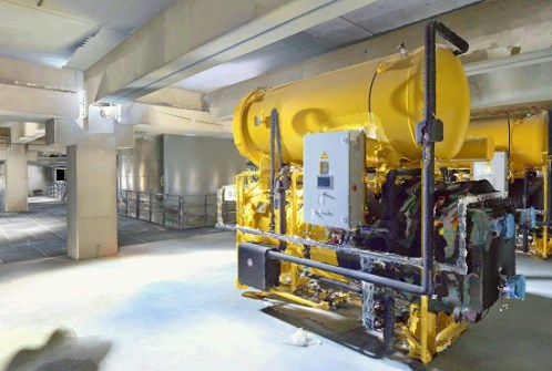
For commercial buildings and utilities, comprehensive documentation of as-built conditions provides the foundation for effective facilities management. Aptella’s SLAM laser scanning solutions, including the NavVis MLX and VLX, create detailed point clouds of both exterior and interior spaces.
These point clouds serve as the basis for building information models (BIM) that incorporate both visible features and hidden infrastructure. Facility managers gain access to comprehensive digital twins that can be used for space planning, maintenance scheduling, and retrofit design.
The Aptella advantage
What differentiates Aptella’s approach to reality capture is comprehensive integration and expert guidance. From initial data collection through processing and final deliverables, Aptella provides cohesive workflows that maximise efficiency and data utility.
“We’ve positioned ourselves as the subject matter experts in the reality capture space,” says Adam Burke, the Executive Manager of Geospatial and Building at Aptella. “When a customer approaches us with a project requirement, they’re not just purchasing hardware — they’re gaining access to our accumulated knowledge and experience.”
“There’s a real satisfaction in presenting a cutting-edge piece of technology to a customer,” agrees Preece.
“When you’re confident that it’s reliable, stable, and performs seamlessly, and then you receive immediate feedback like, ‘This isn’t just impressive technology; it’s actually capable of driving our business forward and boosting our bottom line,’ it’s incredibly rewarding,” he says.
“Being part of that transformation, knowing that the technology not only meets but exceeds expectations, is truly exhilarating.”
Looking forward: The evolving reality capture landscape
As sensors become more compact and processing algorithms more sophisticated, reality capture will continue its evolution toward greater accessibility and application breadth. Aptella remains committed to staying at the cutting edge of these developments, evaluating emerging technologies and integrating those that provide tangible client benefits.
For professionals across surveying, construction, property development, and infrastructure management, this convergence creates new opportunities to enhance efficiency, improve decision-making and deliver superior outcomes.
For more information about Aptella’s comprehensive range of reality capture solutions, visit aptella.com.