

PARTNER FEATURE
Chartis Technology is an Australian success story — a geospatial small business that started in a country town more than 13 years ago, and which has since achieved national reach.
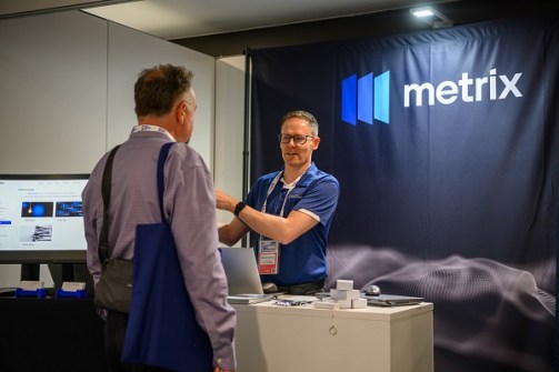
With a wide range of offerings and a particular focus on the local government sector, the company is known for its commitment to the use of open-source technologies such as QGIS. It has even developed its own highly successful product, Metrix, a SaaS enterprise asset management platform.
To find out more about the company, its history, offerings and ambitions, we spoke with its co-founders, Ben Crockett and Matt Robinson.
Please give us a potted history of Chartis Technology.
Ben: Matt and I founded Chartis Technology in Bathurst in 2012. We’d been working together at a previous consulting firm that shifted its focus, and we saw new opportunities opening up in the telecommunications and local government sectors. Our partnerships with Safe Software and the then Digital Mapping Solutions helped us grow as an enterprise spatial solutions provider.
Matt: In those early years we also invested heavily in training and education around open-source technology like QGIS, at a time when the Australian market was very vendor focused. It’s great to see QGIS widely adopted today, and we continue supporting those open-source projects.
Does having your base in a rural town provides any advantageous insights into what your clients need?
Ben: Yes, understanding the diverse needs of regional customers, their budget constraints and their training opportunities around technology, is key to supporting them well. In more recent years, communication networks and online meeting technology have bridged the gap in our sector, allowing us to deliver education, training and ongoing support to customers across the country.
Matt: Being regional ourselves means we genuinely understand the context our clients work in every day, because we’re working in it too.
Do you do business only in NSW, or do you have clients around the nation?
Matt: While most of our customers are on the east coast, we’ve always formed strong partnerships with clients nationally, offering a wide range of enterprise spatial solutions. Many of these relationships are longstanding and have grown with us over the years.
Ben: We also partner with companies that have employees on the ground in all parts of Australia, so wherever our customers are based, they have a local point of contact and a network of support behind them. That combination of reach and regional grounding works well for us and for them.
Is it fair to say that most of your clients are local governments? Has that been your focus?
Ben: Local government has been the cornerstone of Chartis Technology over the years, and that stems from our commitment to supporting regional customers. That said, we’ve also worked across state and federal government, telecommunications, utilities, town planning, ecology and commercial sectors.
Matt: Yes, local government remains our strongest focus, and many of the councils we work with today have been with us for years. We see that continuity as a real measure of the value we deliver, and it’s something we’re genuinely proud of as a passionate, regional business.
What sorts of geospatial challenges do local governments have?
Ben: We see common threads across local government, and through collaboration and partnering with the right people, councils can solve these problems. The big ones we come across are workforce capacity, with internal geospatial resources spread thin; and data quality and currency, where user expectations have grown rapidly over the last five years.
There are also issues with system integration, particularly with cloud-based technology; field data collection; complying with asset management and auditing requirements; data governance and open data; and being prepared for the next generation of technology.
Chartis Technology is well-known for pioneering QGIS in Australia. What was the need for or benefit of moving to QGIS?
Matt: We were working with some of the earlier versions of QGIS before 2012, and back then there were real functionality gaps for enterprise use. We watched QGIS grow, with a global community getting involved and rapidly making it a better product. We saw an opportunity to implement and educate our customers on QGIS as a viable alternative to the products in use at the time. Open standards becoming widely accepted, combined with the need for more people using GIS in their day-to-day work, meant QGIS could be adopted. It’s good to see it now used as a mainstream spatial application, and being a QGIS Sustaining Member is our way of continuing to back the project that’s come so far.
Tell us about your philosophy regarding open source.
Matt: Open-source GIS tools aren’t a new concept, and many open-source components are actually used in vendor-based products like FME and Esri technology. For us, open source is one tool in the toolkit, forming part of our enterprise spatial systems. Using the most suitable open-source technology, and in some cases coupling it with vendor-based solutions, means each architecture we design is fit for purpose.
Ben: The best part of being involved in open-source GIS is the community and working with like-minded people. It has also opened up opportunities for users who previously faced high-cost entry barriers.
Tell us about the current technologies you use and/or provide.
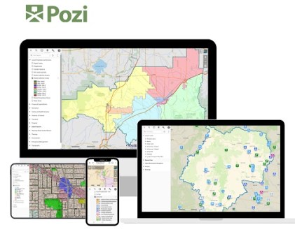
Ben: Our main business is providing enterprise spatial solutions with strong support and training alongside them. QGIS is an important desktop application we work with, usually coupled with other solutions. Pozi is a more recent addition to our range, a QGIS-backed web GIS application. As a distributor and partner of Pozi, we build customer-centric map portals that deliver GIS to consumers, whether inside an enterprise or on public websites.
Matt: We also support the biosecurity vertical with a weed management toolset, plus we work closely with FME products and are a technology partner for EasyEIA, an automated environmental impact assessment toolset.
Tell us about your own in-house solution, Metrix Assets.
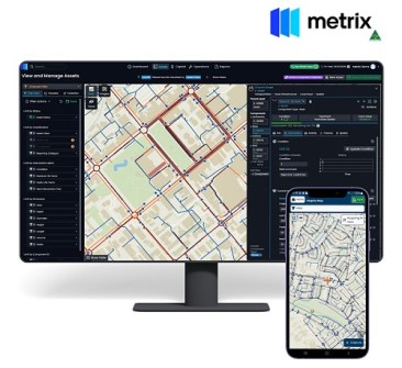
Matt: Metrix Assets is the unsung hero of our product range. It’s gaining real traction in the enterprise asset management space, particularly with councils. Our spatial expertise has allowed us to couple technology with engineering and accounting principles, delivering genuine efficiency to this area of work.
Ben: We built the Metrix SaaS offering from the ground up, right here in Australia, and it’s now certified by Australian Made. The platform includes field-based mobility tools for crews operating, maintaining and repairing infrastructure, bridging the gap between the field and the office. Data collected through Metrix means clearer workflows and more informed decisions about how public money is spent on roads, bridges, pits, pipes and other asset classes.
Looking back, how has the business developed over those years?
Ben: Over the past 13 years, we’ve grown from a small, specialist consultancy into a trusted provider of enterprise spatial solutions. In the early days, much of our focus was on advocacy, education and awareness, particularly around open-source GIS. As the market matured, so did our offerings, expanding into integrated enterprise systems, cloud-based solutions, and purpose-built products like Metrix Assets.
Matt: Our strengths lie in our partnership driven approach, our technical expertise and a deep commitment to regional Australia. Combined with a focus on training, support and long-term customer relationships, that’s what has sustained our growth.
What’s next for the company?
Ben: Looking ahead, Metrix Assets is where a lot of our energy and development focus is going. One of the biggest challenges we see in councils and utilities is fragmented data, siloed across different departments, spreadsheets and systems. Metrix brings that together as a single source of truth, and that’s where we’re really investing.
Matt: Trusted and reliable data will drive the economy for the next technology generation. Our business experience and cutting-edge solutions are in a strong position to deliver this for customers who we work with.
Ben: A good example is Central Tablelands Water, a regional NSW water authority managing water services across the Blayney, Cabonne and Weddin Shires and supplying around 15,000 people across fourteen towns and villages. Metrix Mobile has replaced their paper-based field forms, so their network operators can capture asset locations, conditions and works in real time, even offline in areas with limited mobile reception. Barcoded assets within pump stations are used, so crews can open the Metrix mobile app, scan the barcode and land straight on the right asset record, no searching, no guesswork.
Matt: We know first-hand that regional councils do a lot with a little. If Metrix can take some of that pressure off and give crews and managers better information to work with, that’s a meaningful outcome for us.
Any final thoughts?
Ben: One thing that underpins everything we do is our commitment to people, both our customers and the broader spatial community. While technology is at the core of our business, it’s the relationships we build and the knowledge we share that really define our impact.
Matt: We put a strong emphasis on education and capability building, making sure our customers aren’t just users of technology, but confident practitioners. That’s reflected in our training programs, our support for open source, and our collaboration with industry partners. For us, success is about delivering practical outcomes that matter to regional communities.


