


Here’s our weekly round-up of all the geospatial news that didn’t make it into our normal daily coverage.
If you have a Spatial Snippet to share with our readers, please send us an email.
We’ll begin as usual with some spatial and surveying jobs that we’ve spotted over the past week. And just a reminder that, despite the advertised application deadlines, sometimes these jobs are filled or withdrawn by the time we get to publicise them.
Beginning in Victoria, the Department of Transport and Planning’s Planning and Land Services group is looking for a Licensed Surveyor to provide technical advice and services in the areas of survey and road declaration. The successful applicant will have responsibility for oversight and execution of a range of survey and road declaration-related activities such as undertaking cadastral surveys, the provision of technical advice to DTP/VIDA projects, reviewing and processing surveys undertaken by internal staff and others, provision of technical advice and maintenance of DTP standards and guidelines and the adherence to safe work practices. Applications close 12 May.
The Victorian Department of Energy, Environment and Climate Action is seeking a Program Support Officer Public Land Services to contribute to place-based delivery of high-quality, timely regional land management projects and services, in partnership with land managers, including public land asset, safety and risk management, and regulation for use and access to public land. Applications close 10 May.
In South Australia, the City of Tea Tree Gully needs a Systems Analyst / Developer (GIS) to play a role in optimising the City’s GIS environment to support the requirements of works management, and build a range of geospatial digital solutions to improve and gain efficiencies. The position calls for someone with a strong technical background, problem-solving skills and a deep understanding of ArcGIS and Esri best practices. Applications close 7 May.
In Queensland, the Department of Primary Industries is looking for a Resource Management Officer to join the Forestry Resource Management team. The role entails assessing resource availability, condition and location by analysing and managing spatial and non-spatial datasets using a range of operational and resource management systems. Applications close 11 May.
In New South Wales, the Department of Climate Change, Energy, the Environment and Water is seeking to fill several positions of Project Officer, Spatial Services and Customer Delivery. The successful applicant will need sound knowledge of current NSW policy and programs for delivery of regulatory map reviews, along with demonstrated expertise in computer-based mapping and spatial analysis of biodiversity and environmental data. Applications close 3 May.
Also in NSW, the Department of Planning, Housing and Infrastructure’s Corporate Services needs a Senior Application Developer Spatial to play a role in developing and maintaining software and system solutions for spatial data and applications. Day-to-day operations include implementing and managing spatial data practices, promoting technology adoption, and providing technical consulting to align solutions with ICT strategy and architecture. Applications close 6 May.
The same department is also seeking a Geospatial Technical Specialist to act as the go-to technical contact for geospatial applications, providing expert support, troubleshooting issues, and advising on solution design. The successful application will also lead deployments into controlled environments, contribute to new GIS projects, and work with both internal teams and external providers to ensure high-quality, secure, and user-focused outcomes. Applications close 12 May.
The Office of the Registrar General within the NSW Department of Customer Service has an opening for a Graduate Surveyor to provide office and field support to the Cadastral Integrity team. The role will provide the successful applicant with an opportunity to develop skills and experience, whilst working towards becoming a registered land surveyor.
Finally, if you feel like a real change of scenery, DT Global is seeking a Data and GIS Specialist to join its South-East Asia team on the Education Quality for Inclusive Prosperity program, a joint effort of the Australian and Philippines governments. The wide-ranging role has responsibilities that include designing, developing, testing and continuously improving GIS-enabled information systems to manage location-based data; providing day-to-day support functions; and developing and implementing a data collection strategy. Applications close 8 May.
NSW Land Registry Services (LRS) has a new CEO, Clark Butler, who was appointed effective 1 April. Butler, who had served as interim CEO of LRS since October 2025, joined the agency’s board in February 2025. Previously he was a director of SERV, has served as a board member and interim CEO of illion, and was the Strategy Advisor and Company Secretary for Veda Group Limited (now Equifax).
Still with LRS, and the agency has announced that it is continuing to work closely with industry on the transition to 100% digital plans, including how plans are prepared, lodged and registered. LRS says surveying professionals are encouraged to begin integrating Digital Forms and digital plan file preparation into their workflows, and register for weekly support sessions.
Congratulations are in order for the Copernicus Australasia Regional Data Hub, which is celebrating its 10th anniversary this year. The Hub is a national infrastructure service that relays, stores and serves Sentinel satellite imagery for the Australasia region. It was established as part of an agreement between Australia and the European Union to collaborate on the promotion and exploitation of data originating from the Copernicus Program.
On the subject of Copernicus, the program has put together a list of digital tools that will be of interest to professionals working in climate and atmospheric fields. The tools deal with subjects such as heat and cold across the planet, long-term climate conditions (building on 85 years of data), interactive climate projections, methane plumes, and aerosol alerts.
The Committee on Earth Observation Satellites (CEOS) has released its Interoperability Handbook 2.0 to “help data providers enhance the interoperability of their data and services with those of other organisations, agencies, and countries, which will help in avoiding duplication of efforts, reduce costs, and improve the interoperability of EO data and services”. The new Handbook builds on version 1.1, which was released way back in 2008, since when the number and range of Earth observation satellites and providers has skyrocketed.
Swisstopo, Switzerland’s Federal Office of Topography, is celebrating 100 years of the use of aerial photography since it established its own flight service in 1926. To mark the occasion, a special book and postage stamp have been produced.
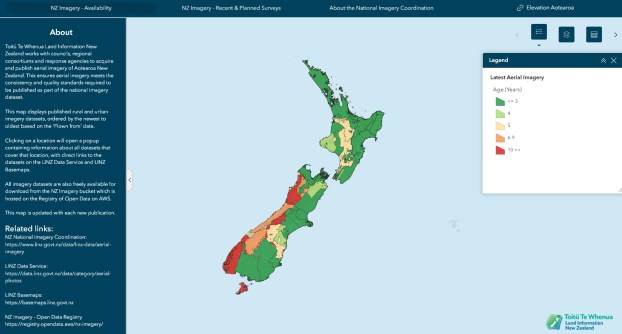
Speaking of aerial imagery, did you know that Toitū Te Whenua Land Information New Zealand has a special website that shows the most up-to-date publicly available aerial imagery? The information is freely available under an open licence.
And finally, publisher Springer Nature Group, under its Scientific Reports collection, is calling for submissions of original research in the field of geospatial data science and analysis. Sibling journal Scientific Reviews is seeking submissions of narrative works in the same field. If you’re interested, you have plenty of time — the deadline is 22 January 2027.
Make sure you don’t miss out any geospatial news from across Australia and around the world — subscribe to our free Spatial Source newsletter, sent out every Wednesday and Friday morning.


