Learn how to ‘geo-enlighten your organisation’ at Directions LIVE 2016.
This year’s roadshow will highlight how you can extend the benefits of geospatial technology throughout your entire business – to streamline workflows and maximise your return on investment.
Discover how to further leverage the ArcGIS platform’s spatial analysis capabilities and see how this technology gives your organisation the competitive edge.
At Directions LIVE 2016, you will learn the benefits of working with 3D and 4D data, how to select the perfect app to tackle any challenge, and how ArcGIS Pro complements ArcMap functionality.
We will also be showcasing the innovative ways local organisations are improving operational efficiency with GIS technology.
Directions LIVE is free for Esri users – with light lunch provided.
Register today to join our team of ArcGIS experts and your local GIS user community, and learn how to unlock the full potential of the platform – the market’s only complete GIS solution.

The FIG Congress — the largest and most prestigious conference of surveying and geospatial professionals — will this year be held in Poland.
The organisers are expecting an attendance of 1,000 to 1,500 surveying and geospatial experts from all over the world.
This year the local host is the Association of Polish Surveyors, and the conference theme is ‘Volunteering for the future – Geospatial excellence for a better living’. Geospatial excellence and all related professions and topics are now seen in a much broader context and as public goods and beneficial for the well-being and betterment of the entire society.
The sub themes are:
- Surveyor 4.0
- The surveying profession in and after COVID times
- Open access to data
- Surveying competence for other disciplines
The FIG Congress 2022 will give passionate professionals the opportunity to:
- Learn globally, with participation from around 80 to 90 countries
- Learn across silos, from other countries, industries and professional roles – with sessions and representation from a broad range of surveyors and geospatial experts
- Have influence on careers, organisations and communities

The Committee of Experts on Global Geospatial Information Management (UN-GGIM) will convene the second United Nations World Geospatial Information Congress (UNWGIC) in Hyderabad, India from 10-14 October 2022.
Hosted by the Government of India through its Ministry of Science and Technology, the convening of the UNWGIC arises out of the mandate from the United Nations Economic and Social Council (ECOSOC) to the Committee of Experts to convene global forums to promote comprehensive dialogue on global geospatial information management with all relevant governments, international organisations and stakeholders.
With an overarching theme ‘Geo-Enabling the Global Village: No one should be left behind,’ the second UNWGIC will reflect the importance of integrated geospatial information to support sustainable development and the wellbeing of society, address environmental and climate challenges, embrace digital transformation and technological development, and catalyse vibrant economies.
The congress addresses the development and strengthening of integrated geospatial information management, its capacities and capabilities, and demonstrates the importance of international cooperation and coordination for building a human data and geography community, against the three pillars of sustainable development, for a shared future and a better world, leaving no one behind within an inclusive and equitable global society.
The UNWGIC will feature a high-level, plenary, special and parallel sessions. While the actual second UNWGIC program covers three days (11 – 13 October), the overall event will be a weeklong (10 – 14 October), and will include global and regional meetings, workshops and learning events, expert meetings and side events, including the eleventh plenary meeting of the Regional Committee of United Nations Global Geospatial Information Management for Asia and the Pacific (UN-GGIM-AP), as well as the annual meeting of the UN-GGIM Expanded Bureau.

The overall theme for the FIG Working Week 2023 will be ‘Protecting our world, conquering new frontiers,’ which refers to the importance of looking ahead and discovering what will be needed in the future for our profession and at the same time make sure to preserve what works well today.
The FIG Working Week 2023 will give passionate professionals the opportunity to:
- Learn globally, with participation from around 80 to 90 countries.
- Learn across silos, from other countries, industries and professional roles, with sessions and representation from the broad range of surveyors and geospatial experts.
- Make impacts on careers, organisations and communities.

The Institute of Navigation’s (ION) Pacific PNT Conference is a global event dedicated to the cooperative development of positioning, navigation and timing technology and applications.
The conference attracts policy and technical leaders from Japan, Singapore, China, South Korea, Australia, the United States and many other countries, who meet to discuss policy updates, receive program status updates and exchange technical information.
The conference will cover a wide range of topics:
- GNSS policy/status
- Polynesian navigation
- Aircraft navigation and surveillance
- Algorithms and methods
- Alternative navigation and signals of opportunity
- Aviation applications of GNSS
- Challenging navigation problems
- Emerging PNT consumer applications
- GNSS-R and GNSS-RO for environmental monitoring
- High-precision GNSS correction and monitoring networks
- Inertial navigation technology and applications
- Interference and spectrum
- Ionosphere monitoring with GNSS
- Natural hazards detection and other remote sensing applications
- Time and frequency distribution
- Space navigation technologies
Substantial discounts are available for early registrations.
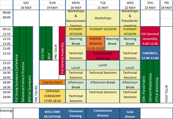
The International Federation of Surveyors (FIG) Working Week 2024 will be held in Accra, Ghana, from 19 to 24 May. The event is being held in cooperation with the two national associations: the Licensed Surveyors Association of Ghana (LiSAG) and the Ghana Institution of Surveyors (GhIS).
The event will comprise the following:
- Conference: 20-22 May
- FIG General Assembly: 19 and 23 May
- Pre- and post-events: 18-19 and 23 May

The FIG Working Week will be a week-long celebration of innovation and collaboration that unites the global community of surveying and spatial professionals, providing an opportunity to bridge the gap between science and the policymakers and stakeholders who drive real-world change.
The event will provide attendees the opportunity to:
- Immerse themselves at the forefront of geospatial technology and sustainable resource management.
- Elevate their expertise through hands-on workshops, interactive sessions, and thought-provoking discussions.
- Connect with like-minded professionals, experts and decision-makers from around the world.
The FIG Working Week 2024 is expected to attract more than 1500 attendees from around 80 countries, to participate in 70-plus presentation sessions and networking opportunities, and to experience a comprehensive trade exhibition.


