AVALON 2019 – THE ESSENTIAL AVIATION, AEROSPACE AND DEFENCE SHOWCASE FOR AUSTRALIA AND THE ASIA PACIFIC REGION
The Asia Pacific region is undergoing major growth in defence and aviation, with budgets in many countries continuing to rise and an ever increasing level of sophistication in technologies, equipment, systems and operational methods.
One of the leading gateways to these important markets is AVALON 2019 – the Australian International Airshow and Aerospace & Defence Exposition staged at Avalon Airport, Geelong, Victoria.
AVALON 2019 will again present a unique opportunity to showcase products, technologies and services to an informed target audience and to demonstrate a marketing presence in this vibrant and vital region. High levels of economic growth and technological development have resulted in growing demand for aviation and aerospace services, products and technology, right across the spectrum from General Aviation to airlines, air forces and space.
AVALON 2019 will be a valuable opportunity for decision-makers to be informed and for exhibitors to connect with their customers.
The Australian International Airshow and Aerospace & Defence Exposition is the essential aviation, aerospace and defence event for the Asia Pacific.

Join Bentley Systems at the launch of what it says is the industry’s most complete Survey and Site Design Solution ever offered to the ANZ market.
As technology advances and industry expectations increase, your software needs to keep pace with this ever-changing environment. In short, your software needs to deliver on today’s requirements and be ready for tomorrow’s challengers.
If you work in road design, site surveying, site development and related fields, this webinar is for you.
Throughout the launch, Bentley Systems will demonstrate traditional survey data capture capabilities, coupled with the latest mass data collection survey methods, including Total Station techniques, Point Cloud techniques and Digital Photogrammetry techniques.
Leveraging the above survey results, the launch will continue through a typical site design workflow, incorporating aspects such as:
- Terrain creation and analysis
- Urban road widening design
- Carpark and recreational area design
- Drainage and Utility design and analysis
- Plan production and digital model delivery
- Model visualisation
Air Inspect Australia will also be joining the webinar to share their insights and learnings of their project.
If you or your company perform any of the above-mentioned workflows, then this is one webinar you should not miss.

The International Cartographic Association (ICA) Commission on Atlases, the ICA Commission on Map Design, the Joint ICA-IGU Commission on Toponymy, the National Geographic Institute of Spain (IGN) and the Spanish Society for Cartography, Photogrammetry and Remote Sensing (SECFT) will jointly host a conference on atlases, toponymy and map design in Madrid.
During six sessions of four presentations each, questions concerning evolving dissemination concepts and techniques for atlases, recent development and examples of national atlases as well as important map design and toponomastic issues in atlas production will be discussed.
The theme of the event will be ‘Atlases in time’. Presentations will be held in a 20-minute format of 15 minutes presenting and 5 minutes discussion.

The 15th International Conference on Spatial Information Theory, COSIT 2022, will be held in Kobe, Japan, 5 to 9 September, 2022. Established in 1993, the Conference on Spatial Information Theory (COSIT) is a biennial international conference series concerned with theoretical aspects of space and spatial information, aimed at advancing geographic information science and its emerging research frontiers.
The conference offers three (refereed) submission tracks with double-blind reviews: vision papers, full papers, and short papers. Embedded in the conference will also be an on-site mentoring program for doctoral students.
Contributions can cover a broad set of conference-relevant themes such as (but not limited to):
- activity-based models of spatial knowledge
- cognitive aspects of geographic information
- cognitive-behavioural geography, naive geography
- data-driven spatial information theory
- geo-ethics and geo-privacy
- events and processes in geographic space and time
- geographic information visualisation and geovisual analytics
- knowledge representation for space and time
- navigation and wayfinding of sentient beings and robots
- ontology of space and time
- place
- quality and interoperability of geographic information
- social and cultural organisation of space
- spatial and temporal language
- spatial aspects of social networks
- spatial decision support, impact of model design
- spatial (digital) humanities
- theory-driven spatial machine learning, artificial intelligence of space
- theories on volunteered geographic information
- theory and practice of spatial and temporal reasoning
- user interfaces, virtual spaces and collaborative spaces

The FIG Congress — the largest and most prestigious conference of surveying and geospatial professionals — will this year be held in Poland.
The organisers are expecting an attendance of 1,000 to 1,500 surveying and geospatial experts from all over the world.
This year the local host is the Association of Polish Surveyors, and the conference theme is ‘Volunteering for the future – Geospatial excellence for a better living’. Geospatial excellence and all related professions and topics are now seen in a much broader context and as public goods and beneficial for the well-being and betterment of the entire society.
The sub themes are:
- Surveyor 4.0
- The surveying profession in and after COVID times
- Open access to data
- Surveying competence for other disciplines
The FIG Congress 2022 will give passionate professionals the opportunity to:
- Learn globally, with participation from around 80 to 90 countries
- Learn across silos, from other countries, industries and professional roles – with sessions and representation from a broad range of surveyors and geospatial experts
- Have influence on careers, organisations and communities

The overall theme for the FIG Working Week 2023 will be ‘Protecting our world, conquering new frontiers,’ which refers to the importance of looking ahead and discovering what will be needed in the future for our profession and at the same time make sure to preserve what works well today.
The FIG Working Week 2023 will give passionate professionals the opportunity to:
- Learn globally, with participation from around 80 to 90 countries.
- Learn across silos, from other countries, industries and professional roles, with sessions and representation from the broad range of surveyors and geospatial experts.
- Make impacts on careers, organisations and communities.
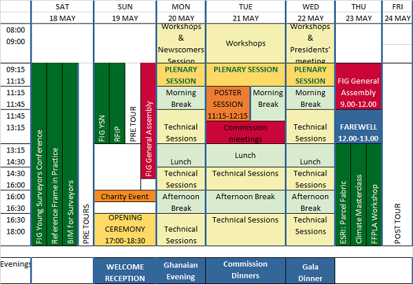
The International Federation of Surveyors (FIG) Working Week 2024 will be held in Accra, Ghana, from 19 to 24 May. The event is being held in cooperation with the two national associations: the Licensed Surveyors Association of Ghana (LiSAG) and the Ghana Institution of Surveyors (GhIS).
The event will comprise the following:
- Conference: 20-22 May
- FIG General Assembly: 19 and 23 May
- Pre- and post-events: 18-19 and 23 May

The FIG Working Week will be a week-long celebration of innovation and collaboration that unites the global community of surveying and spatial professionals, providing an opportunity to bridge the gap between science and the policymakers and stakeholders who drive real-world change.
The event will provide attendees the opportunity to:
- Immerse themselves at the forefront of geospatial technology and sustainable resource management.
- Elevate their expertise through hands-on workshops, interactive sessions, and thought-provoking discussions.
- Connect with like-minded professionals, experts and decision-makers from around the world.
The FIG Working Week 2024 is expected to attract more than 1500 attendees from around 80 countries, to participate in 70-plus presentation sessions and networking opportunities, and to experience a comprehensive trade exhibition.


