We are pleased to announce our Qld Conference Highlights Webinar Series, showcasing some of the most popular presentations from our 2019 Qld Surveying & Spatial Day, Central Group and Northern Group Conferences.
First up is Dale Atkinson, presenting Native Title and the role of Cadastral Surveyor.
There have been over 120 Native Title Determinations registered in Queensland alone. Complicated legal concepts, lengthy federal court judgements and cultural sensitivities have made this a very avoidable issue for the cadastral surveyor. This talk attempts to provide a basic understanding and argues that there is a vital role for cadastral surveyors to play in this process.
Dale is a cadastral surveyor that runs a small rural based practice in North Queensland. He has a keen interest in rural surveying and maintains a good relationship with many retired rural surveyors. Dale is currently the Chair of the Qld Land Surveying Commission Committee.
Don’t forget to check out our other webinars here.
Registration
By registering below, you receive access to the watch the webinar live OR if you can’t watch it live, you receive the link to the recording 24 hours after the event date. You can then watch the recording at your leisure.
BOSSI CPD
BOSSI CPD points have been assessed as below. The event code for BOSSI is: tbc
- 1.00 BOSSI Cadastral points for live viewing
- 1.00 BOSSI Cadastral points for viewing the recorded webinar if accompanied by a questionnaire with 80% pass mark (contact Katie for a copy)
- 0.5 BOSSI Cadastral CPD points for viewing of the recorded webinar with no questionnaire
Contact
Katie Le Miere
rom.qld@sssi.org.au

Held on Sunday, 9th February, 2020, the SSSI National Bushfire Recovery Map-a-thon was a way for the national and international community to work together to map a total of 2,793,879 hectares affected by recent Australian bushfires with the focus being on burnt infrastructure. Join us for this Webinar to hear more about the initiative.
Speakers:
Dr Lesley Arnold (SSSI National Board Director) will give an overview of the Map-a-thon initiative and discuss overall logistics of planning; industry, government and NGO engagement; the challenges and overall execution of the event.
Nathan Eaton, Executive Director, NGIS Australia will give an overview of the technical set-up of this mammoth Map-a-thon and highlight some of the challenges and triumphs experienced.
This is a free event open to those who participated in the Map-a-thon or are involved in the surveying and spatial community.
Details about how to join the Webinar will be emailed to you prior to the event.
To read more about the SSSI National Bushfire Recovery Map-a-thon see the news item here

Organised by OSGeo, this international annual gathering of location enthusiasts is the largest global gathering for geospatial software. Now in its 15th year, FOSS4G (ie. Free and Open Source Software for Geospatial) brings together developers, users, decision-makers and observers from a broad spectrum of organisations and fields of operation.
Through six days of workshops, presentations, discussions, and cooperation, FOSS4G participants create effective and relevant geospatial products, standards, and protocols. The 2021 event will be focused for the first time on South America and will be held with the close collaboration of the GeoLibres Association in Buenos Aires, Argentina.

The 16th annual congress of the Open Source Geospatial Foundation, the non-profit organisation that supports and promotes the collaborative development of free and open source geographic technologies and open geospatial data, will be held in Florence, Italy, at the Palazzo dei Congressi, Palazzo degli Affari and the University of Florence.
FOSS4G (ie. Free and Open Source Software for Geospatial) brings together developers, users, decision-makers and observers from a broad spectrum of organisations and fields of operation.

The FIG Congress — the largest and most prestigious conference of surveying and geospatial professionals — will this year be held in Poland.
The organisers are expecting an attendance of 1,000 to 1,500 surveying and geospatial experts from all over the world.
This year the local host is the Association of Polish Surveyors, and the conference theme is ‘Volunteering for the future – Geospatial excellence for a better living’. Geospatial excellence and all related professions and topics are now seen in a much broader context and as public goods and beneficial for the well-being and betterment of the entire society.
The sub themes are:
- Surveyor 4.0
- The surveying profession in and after COVID times
- Open access to data
- Surveying competence for other disciplines
The FIG Congress 2022 will give passionate professionals the opportunity to:
- Learn globally, with participation from around 80 to 90 countries
- Learn across silos, from other countries, industries and professional roles – with sessions and representation from a broad range of surveyors and geospatial experts
- Have influence on careers, organisations and communities

The overall theme for the FIG Working Week 2023 will be ‘Protecting our world, conquering new frontiers,’ which refers to the importance of looking ahead and discovering what will be needed in the future for our profession and at the same time make sure to preserve what works well today.
The FIG Working Week 2023 will give passionate professionals the opportunity to:
- Learn globally, with participation from around 80 to 90 countries.
- Learn across silos, from other countries, industries and professional roles, with sessions and representation from the broad range of surveyors and geospatial experts.
- Make impacts on careers, organisations and communities.
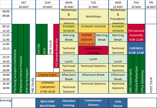
The International Federation of Surveyors (FIG) Working Week 2024 will be held in Accra, Ghana, from 19 to 24 May. The event is being held in cooperation with the two national associations: the Licensed Surveyors Association of Ghana (LiSAG) and the Ghana Institution of Surveyors (GhIS).
The event will comprise the following:
- Conference: 20-22 May
- FIG General Assembly: 19 and 23 May
- Pre- and post-events: 18-19 and 23 May

The FIG Working Week will be a week-long celebration of innovation and collaboration that unites the global community of surveying and spatial professionals, providing an opportunity to bridge the gap between science and the policymakers and stakeholders who drive real-world change.
The event will provide attendees the opportunity to:
- Immerse themselves at the forefront of geospatial technology and sustainable resource management.
- Elevate their expertise through hands-on workshops, interactive sessions, and thought-provoking discussions.
- Connect with like-minded professionals, experts and decision-makers from around the world.
The FIG Working Week 2024 is expected to attract more than 1500 attendees from around 80 countries, to participate in 70-plus presentation sessions and networking opportunities, and to experience a comprehensive trade exhibition.


