The Future of Place Summit aims to be a day filled with critical discussion, knowledge sharing and networking around the intersection of people, place technology and data.
The event will focus on four themes:
- Designing for digital lifestyles — A new human-centred planning approach
- From precinct plans to development reality — The evolving digital and data DNA of urban growth
- Data-inspired discussions — Tapping into the real voice of the community
- Streets reimagined — The digital backbone for better experiences
Delegates can take part in person or via Zoom.

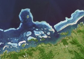
Hydrographers and all those with an interest in hydrography and related disciplines, are invited to attend a World Hydrography Day 2023 Seminar in Suva, Fiji, on 22 and 23 June.
The seminar will be held jointly by the Australasian Hydrographic Society and the Fiji Hydrographic Service. The venue will be the Moana Anglican Services and Teaching Centre at St John the Baptist Theological College.
The organisers are calling for potential sponsors and presenters to get in touch.
The theme for World Hydrography Day 2023 is ‘Hydrography: Contributing to the United Nations Ocean Decade’.
The seminar comes after a two-year pause due to the COVID pandemic and associated travel restrictions. It will provide an opportunity for professionals to network and share hydrospatial knowledge through presentations and discussion.
It is also intended that the presentations will highlight the empowerment of women within the hydrography field.
Registration is free but places are limited. Registrations must be secured by close of business, Tuesday, 20 June 2023.

The Tasmanian Spatial Information Council (TASSIC) will hold a Geospatial Workforce Development Forum on 9 November 2023, to help shape the future of the geospatial sector in Tasmania.
The Forum will bring together key stakeholders from education, employers, government and suppliers to address critical challenges and opportunities facing the sector.
The Forum will include presentations from representatives of industry, government and the education sector, as follows:
- Paul Digney (Jacobs)
- Rob Rowell (Insight GIS)
- Ben Morris (Local Government Association of Tasmania)
- Michael Krome (Australian Spatial Analytics)
- Arco Lucieer (University of Tasmania)
- Sam Ebert (TAFE NSW)
- Troy Robbins (TasTAFE)
The event will conclude with a moderated discussion session led by Danika Bakalich (Geospatial Council of Australia).
The Forum will be a hybrid event with both in-person and online attendance options available, and it will employ the Menti-Meter program to facilitate discussions, ensuring that each delegate’s voice is heard and their input valued.
Image credit: ©stock.adobe.com/au/borisblik

The 4th International Symposium on Applied Geoinformatics (ISAG2024), which will take place at the Wroclaw University of Science and Technology, Wroclaw, Poland, on 9 and 10 May 2024. ISAG2024 is jointly organised by the Department of Geomatics Engineering, Yildiz Technical University, Istanbul, Türkiye, Wroclaw University of Science and Technology, Wroclaw, Poland and Technical University of Crete, Chania, Crete, Greece.
The aim of the 4th ISAG is to bring scientists, engineers and industry researchers together to exchange and share their experiences and research results and discuss the practical challenges encountered and the solutions adopted in geoinformatics.
Topics to be covered include recent advances in AI, satellite imagery, advanced remote sensing, photogrammetry, image processing, global navigation satellite systems, height systems, terrestrial laser scanning, GIS, smart cities and land management.


