
The National Surveying Congress will be an opportunity for leaders in the surveying profession to discuss the opportunities and challenges facing the profession. The 2022 Congress theme is ‘Automatic Mutual Relaxation’.
As the profession comes to understand the impact of Automatic Mutual Recognition for surveyors across the country, the event will provide an opportunity for surveyors from across Australia to gather and discuss the issues facing the profession and the opportunities for the future. The highlight of the program each year is the Cadastral Leaders Panel which sees all the Surveyors-General on stage speaking about changes and opportunities in their states and territories as well as an update from ICSM and ANZLIC. There will also be an online option.
The National Surveying Consultancy Excellence Awards and Gala Dinner will be held on the second day of the event, 23 June 2022.
The Australasian Hydrographic Society NZ Region, in conjunction with the Space & Spatial New Zealand Hydrography Stream, are holding a 1-day seminar on Friday, 8 July 2022 at the Miramar Golf Club, Wellington.
The seminar will align closely with the IHO’s World Hydrography Day theme “Hydrography – contributing to the United Nations Ocean Decade”.

Survey and Spatial NZ’s 2022 conference will be held from 1 to 3 August at the Novotel Lakeside, Rotorua. The conference is the biggest continuing professional development event of the year for NZ surveying and spatial professionals. It invites sharing of knowledge amongst peers, bringing together networking opportunities for all delegates and is an essential event for professional development and connectivity within the sector.
The choice of Rotorua as the location is apt, given the conference theme of ‘Turning up the Heat’. The organisers aim to stimulate discussion regarding challenges in regional areas, which include climate change and developments outside of Auckland.
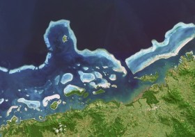
Hydrographers and all those with an interest in hydrography and related disciplines, are invited to attend a World Hydrography Day 2023 Seminar in Suva, Fiji, on 22 and 23 June.
The seminar will be held jointly by the Australasian Hydrographic Society and the Fiji Hydrographic Service. The venue will be the Moana Anglican Services and Teaching Centre at St John the Baptist Theological College.
The organisers are calling for potential sponsors and presenters to get in touch.
The theme for World Hydrography Day 2023 is ‘Hydrography: Contributing to the United Nations Ocean Decade’.
The seminar comes after a two-year pause due to the COVID pandemic and associated travel restrictions. It will provide an opportunity for professionals to network and share hydrospatial knowledge through presentations and discussion.
It is also intended that the presentations will highlight the empowerment of women within the hydrography field.
Registration is free but places are limited. Registrations must be secured by close of business, Tuesday, 20 June 2023.

The Local Government Spatial Reference Group (LGSRG) will be holding a webinar on Monday, 4 September, to introduce a series of hands-on workshops it will be holding across Victoria during September 2023.
The webinar will cover the topic of Best Practice Geospatial Intelligence for Climate Impact, and will address important topics on climate impact, community safety and how geospatial intelligence can contribute to better outcomes for local governments.
The LGSRG was formed in 2003 to address the need for a sector wide group representing the strategic interests of the Victorian Local Government sector with respect to spatial information. The LGSRG has been active throughout the COVID pandemic to keep the local government geospatial community connected and engaged via the annual Spatial Capability Workshop series which have grown year on year, and is now diversifying with a quarterly Spatial Hour webinar to share stories of success within the local government geospatial sector.
Image credit: ©stock.adobe.com/au/yutthana

GeoBuiz Summit is an annual international conference focused on the geospatial industry, which encompasses a range of technologies and applications related to mapping, location-based services, and spatial data analysis.
The summit brings together industry leaders, government representatives, experts, and innovators to discuss the latest trends and innovations in geospatial technology and applications.
The conference covers a range of topics, including geospatial infrastructure, mapping and surveying, satellite imagery and remote sensing, location-based services, smart cities and urban planning, and much more. The GeoBuiz Summit aims to promote collaboration and knowledge-sharing within the geospatial industry and to showcase the latest developments in this exciting and rapidly evolving field.
The Remote Hydrography conference and exhibition brings together manufacturers, operators, regulators, and research and development leaders from both industry and academia, within the field of remote surveying and uncrewed survey operations.
Remote Hydrography 2024 provides an opportunity to share experience gained in the development and application of autonomous and uncrewed platforms (surface, underwater, aerial and space-based) and the associated command and support services.
These and enabling technologies like machine learning and artificial intelligence will revolutionise workflows for hydrographic data collection, processing, analysis and presentation.

The 3rd International Land Management Conference, hosted by the University of the West of England, will be held online on 14 and 15 March 2024. The event will bring together experts and professionals in land management to discuss inclusive land tenure, efficient land markets, sector reform and innovations in land research.
The conference will focus on four themes:
- Theme 1: Can we build more inclusive and resilient land tenure systems by understanding social value and climate change?
- Theme 2: How can land administration systems contribute to efficient and equitable land markets?
- Theme 3: What approaches can Development Partners use to help achieve more successful Land Administration sector reform?
- Theme 4: LINK – Early Career Professionals and Junior Researchers – Innovations in Land Research and Practice
The conference is organised by LINK, the Land–International Network for Knowledge — a network of academic organisations, professional practice and development partners, as well as public and private sector country partners — in association with the University of the West of England.

The not-to-be-missed Geospatial Council of Australia (GCA) South Australia Cadastral Workshop, to be held in Adelaide on 16 March, will bring together professionals in the field of land surveying and provide an opportunity for them to expand their knowledge of the complexities of cadastral surveying.
This workshop offers a unique opportunity for professionals in the field of land surveying to gather and expand their knowledge in the complexities of cadastral surveying. Participants will hear expert-led discussions into topics ranging from advanced surveying techniques to legal frameworks governing land boundaries, and gain invaluable insights to enhance their expertise and address the challenges of modern cadastral surveying practices.
- Members: $90 (incl. GST)
- Non-members: $135 (incl. GST)
- Registered survey graduates and students: $45 (incl. GST)

The Geospatial Council of Australia’s World Hydrography Day Seminar will dive deep into the latest advancements in hydrographic surveying, mapping technologies and data analysis techniques.
The event will give delegates the opportunity to connect with fellow professionals, share experiences and learn from industry leaders at the forefront of marine charting and exploration.
For both seasoned experts and those just starting out in the field, the event promises invaluable insights and networking opportunities to enhance skills and advance careers.
Image credit: ©stock.adobe.com/au/HENADZ


