The 42nd Canadian Symposium on Remote Sensing will be a virtual event that will bring together academics, practitioners, vendors and policymakers from the remote sensing community in an informative and productive four-day event under the theme of Understanding Our World: Remote Sensing For A Sustainable Future. It fill have special sessions, general sessions, keynotes, panel discussions and workshops featuring speakers from around the world. Attendees will enjoy both technical sessions and networking opportunities online.

FIRA is a leading global event series, which this year is focused on the new era of robotics in agriculture and the huge impact it will have on the whole value chain. For the sixth year running, FIRA will be a hybrid in-person/online event, and is expected to attract 3000-plus attendees from around the world, including robot manufacturers, agricultural businesses, producers, investors, suppliers and entrepreneurs.

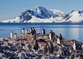
Since the establishment of Scott Base on Ross Island by the late Sir Edmund Hillary in 1957, surveyors have been appointed to assist scientists with survey related tasks on the ice.
This presentation by a panel of Antarctic surveyors promises to be educational, entertaining and informative, as they talk about their experiences on projects on the frozen continent over the last 35-plus years.
Image credit: ©stock.adobe.com/au/hrathke

GeoBuiz Summit is an annual international conference focused on the geospatial industry, which encompasses a range of technologies and applications related to mapping, location-based services, and spatial data analysis.
The summit brings together industry leaders, government representatives, experts, and innovators to discuss the latest trends and innovations in geospatial technology and applications.
The conference covers a range of topics, including geospatial infrastructure, mapping and surveying, satellite imagery and remote sensing, location-based services, smart cities and urban planning, and much more. The GeoBuiz Summit aims to promote collaboration and knowledge-sharing within the geospatial industry and to showcase the latest developments in this exciting and rapidly evolving field.


