

Hudson Pear is a serious invasive pest. ©stock.adobe.com/au/Gonzalo
Mobile mapping is revolutionising how the Hudson Pear invasive species can be located and controlled.
PARTNER FEATURE
By Lyn Terrett
Efforts to deal with invasive weeds are emphasising just how crucial spatial detection and monitoring technologies are in the prevention of environmental disasters. Weed management is an essential activity that safeguards our economy, the environment and communities.
Since 1993, the founding directors of RapidMap have assisted biosecurity officers to map and manage weeds on private and public lands using GPS/GNSS and mobile mapping applications such as Summit Biosecurity (originally called WeedMap Pro). Spatial metadata models are embedded in Summit Biosecurity’s easy-to-use mapping interface to help automatically collect and collate a single source of GIS-based truth as related to field-based inspections.
The Castlereagh Macquarie County Council is a perfect example of how a motivated organisation has been able to use Summit Biosecurity’s mobile mapping interface to empower the local community to rally against the insidious Hudson Pear cactus.
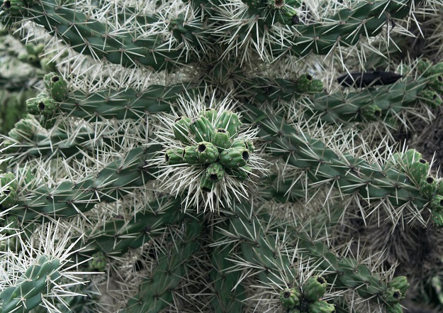
Hudson Pear is an invasive species of Mexican origin that has purple flowers, large deadly spines and grows up to 1.5 m high and 3 m wide. It can grow essentially anywhere, with or without water or good soil. Spreading easily and rapidly, the smallest fragments can be transported by animals or vehicles to other properties where it can quickly take hold.
Hudson Pear has very serious ramifications for the environment. It can devalue land, and the spines having a sheath that stays in the wound after removal, resulting in pain, inflammation, infection, and the potential for the death of people, livestock, native wildlife and pets, if left untreated.
Found mainly in the north-west of New South Wales, infestations have also been found in the ACT, Queensland, South Australia, Victoria and Western Australia. It is estimated to have affected around 100,000 hectares in NSW alone, which is why new research into the effectiveness of biological control methods — along with community engagement to establish volunteer groups that use Summit Biosecurity to map and monitor treatment activities and results — have been of strategic importance.
Over the years, landowners found that Hudson Pear was too large a problem to deal with physically, psychologically and financially. Many would treat an area, but it would sometimes come back quickly as Hudson Pear does not need seeds to reproduce.
Summit Biosecurity has provided a powerful, evidence-based data capture application to support improvements to how Hudson Pear can be located, monitored, treated and controlled. Mobile mapping to record locations and treatments, and monitoring to control spread, has been essential to prove the benefits of biological control over traditional herbicide approaches. A cochineal bug, Dactylopius tomentos (‘Californica var. parkeri’ lineage) has now been proven to provide good biological control of Hudson Pear in NSW.
By mapping and monitoring the success of herbicide treatments against biological control releases, it has been found that while direct application can be effective, the smallest fragments that are missed will take hold later. But it has now been proven that with biological distribution control, the previously hard-to-find Hudson Pear fragments are found and attacked by the cochineal bug, containing the incursion long after the biosecurity officer, volunteer or contractor has left the property.

Volunteers in the Castlereagh Macquarie County Council’s district, gather to take the fight to the Hudson Pear.
Biosecurity officers at Castlereagh Macquarie County Council continue to work closely with a group of volunteer farmers and community members to fight the Hudson Pear. Once the trial releases of the cochineal bug proved successful, the group used the mapping evidence to inspire the local community so they too could assist.
Summit Biosecurity provided the spatial and temporal data needed to accurately represent the successful results at each property. Funding was then secured with NSW DPI for the construction of a new greenhouse to use as a mass rearing facility to address the demand for more cochineal infected fragments.
Remote and under-resourced regional organisations can achieve professional GIS data capture inexpensively with the help of the RapidMap team. To learn more about the Hudson Pear program at Castlereagh Macquarie, check out the interview with Senior Biosecurity Officer, Andy Fletcher: https://www.youtube.com/watch?v=T5hnG497rLM.
The Castlereagh Macquarie team will present at the 22AWC conference in Adelaide in September 2022, and the author will share more insights at the South Australian Spatial Information Day. Further information can be found at www.iconyx.com or https://cmcc.nsw.gov.au/hudson-pear-2/.
Lyn Terrett is Spatial Technologies Director at RapidMap and Iconyx.


