

Maps Mania
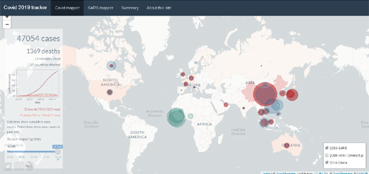
A new interactive map from the London School of Hygiene & Tropical Medicine London School allows you to compare how Covid-19 compares to previous virulent epidemics.
Google redraws the borders on maps depending on who’s looking

The Washington Post
Google’s corporate mission is “to organise the world’s information,” but it also bends it to its will. From Argentina to the United Kingdom to Iran, the world’s borders look different depending on where you’re viewing them from. That’s because Google — and other online mapmakers — simply change them.

The Map Room
We expect maps to tell the truth; indeed we need them to on a fierce and primal level. “I believe cartography enjoys an enviable position of credibility and confidence among the people who see it. If you see it mapped, you believe,” wrote Charles Blow last fall; he was writing in response to Trump’s petty defacement of a hurricane forecast map with a marker.

Map of the week
Rand McNally is a giant in the world of cartography, dominating the US market during the pre-internet era and still producing maps and road atlases. The company began as a printing shop in Chicago in 1856. According to company lore (via Wikipedia) the business survived the Great Chicago Fire by burying two printing machines in a beach on Lake Michigan.
The GeoDataViz team’s favourite maps of 2019

Ordnance Survey Blog
A curated ‘best of’ maps made in 2019 from the UK’s Ordnance Survey’s cartography specialists.
Stay up to date by getting stories like this delivered to your mailbox.
Sign up to receive our free weekly Spatial Source newsletter.


