

Our weekly round-up of all the geospatial news that didn’t make it into our normal daily coverage.
If you have a Spatial Snippet to share with our readers, please send us an email.
We’ll start as usual with some geospatial job vacancies that we’ve spotted over the past week.
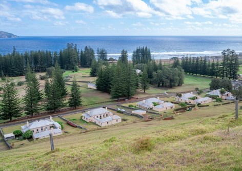
Have you ever fancied becoming a Surveyor General? If you have, then you might be just the person Norfolk Island is looking for. The Pacific paradise is on the hunt for someone to take on the role of SG for an initial period of 12 months, with the primary function being to approve, where applicable, partial and compiled Survey Office plan requests. Applications close 5 June.
In Queensland, the Department of Natural Resources and Mines, Manufacturing and Regional and Rural Development is seeking a Senior Land Officer to lead regulatory land tenure activities on Great Barrier Reef tourism islands, provide advice, manage complex assessments and support compliance while also interpreting legislation and policy, contributing to service improvements and supporting sound land management decisions. Applications close 22 May.
The same Department has a vacancy for a Principal Land Officer to manage and coordinate assessment and compliance functions, oversee staff performance and development, and ensure timely, high-quality service delivery within the Land and Surveying Services section. Applications close 26 May.
Queensland’s Department of Primary Industries has an opening for a Senior Scientist (Data Analytics/GIS) to use their specialist expertise and experience to provide scientific leadership on data analytics/GIS supporting the delivery of contemporary scientific advice, and to contribute to strategic planning and assist external and internal stakeholders to effectively address or manage risks associated with the reporting of the National Electric Ant Eradication Program response plan. Applications close 21 May.
Central Queensland University’s Coastal Marine Ecosystems Research Centre is seeking a Research Officer with expertise in GIS and marine spatial ecology to support applied research across the southern Great Barrier Reef World Heritage Area. The role involves the collection and processing of large spatial datasets and integrating remote sensing and field-based data; undertaking multi-scale spatial analyses across vector, raster and imagery datasets; contributing to publications and supporting data visualisation and communication of research findings to a broad range of stakeholders. Applications close 24 May.
In South Australia, Flinders University has an opening for a Senior Lecturer/Associate Professor in Surveying. The role involves conducting research, teaching, curriculum design, supervising students and building partnerships. Applications close 1 June.
In Victoria, the Department of Energy, Environment and Climate Action has a vacancy for a Project Officer to support the preparation of policy documentation, correspondence and advice to assist in progressing statewide threatened species, invasive species and biodiversity outcomes. Skills in GIS and spatial analysis are desired. Applications close 21 May.
Victoria’s Department of Transport and Planning is seeking a Senior Manager Registry and Cadastre Innovation to lead a specialist land administration team providing expert advice on land administration systems and best practice to senior leaders and government stakeholders, and guide major changes to digital land systems, including the move to fully digital and 3D enabled processes. Applications close 19 May.
Triple Zero Victoria is looking for a Data Group Lead to ensure all emergency services organisations and related government agency dataset (including spatial) requirements are processed, loaded and maintained in its Oracle and SQL database environments. Extensive and demonstrable knowledge and experience using GIS-related software is required. Applications close 24 May.
Finally, the University of NSW has an opening for a Technical Delivery Lead to head the strategic roadmap, delivery and optimisation of core business-as-usual campus solutions IT platforms. The successful applicant will have demonstrated expertise in the application and integration of GIS, BIM and digital twin technologies to enable spatial intelligence, asset visibility, lifecycle management, and data‑driven planning across the built environment. Applications close 19 May.
Other news, events and awards
TASMAP has a new online shop that delivers modern and contemporary features, including on mobile phones. By using the new Interactive Map Search, users can find a high-quality map that best suits their needs.
The US Navy has launched its latest oceanographic survey ship, the USNS Robert Ballard. Named after the famed undersea explorer Robert Ballard who, in 1985, discovered the wreck of the RMS Titanic, the 106-metre-long vessel is to be equipped with multibeam echo-sounders and towed sonars.
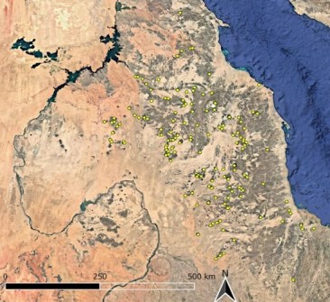
Archaeologists, including team members from Macquarie University, have used satellite imagery to discover 260 previously unknown ‘enclosure burial’ sites across nearly 1,000 kilometres of desert in eastern Sudan. The circular sites, some of which are up to 80 metres wide, are the resting places of not only humans, but also of animals such as cattle, sheep and goats. They’re thought to date from 4000 to 3000 BCE and to have been constructed by nomads.
There are only six months to go now until the LOCATE26/ISDE Summit event begins in Melbourne. The combined conferences will see the Australasian geospatial community (and plenty of overseas guests) come together from 24 to 26 November to discuss, debate and celebrate all the latest developments and trends in the geospatial sector, both here and around the world. Keep an eye on Spatial Source for upcoming announcements or follow the event’s LinkedIn page.
The Advancing Earth Observation Forum will be held from 9-12 November in Hobart. This year’s theme will be ‘Sovereign capability, global impact’ and will see the conference address key issues such as food security, water management, energy, transport, environmental protection, disaster preparedness and climate action. The call for papers has already gone out, so take a look if you’re interested.
Consulting Surveyors NSW will hold its annual state conference at NSW Parliament House on 24 June, where members will get to rub shoulders with a number of government ministers and luminaries from surveying companies. Full details here.
The US-based Women in GIS organisation has announced the winners of its annual map-making contest. There were two overall cohorts — career professional and emerging professional/student — with two awards given in each, one for traditional mapping and one for artistic mapping. You can see the lot via the online story map.
And finally, the University of NSW’s Professor Ashish Sharma has been awarded the 2026 Arid Lands Hydraulic Engineering award from the American Society of Civil Engineers, for developing a new model that uses satellite data and images to predict water level readings and finds patterns in how rivers behave over time. “The World Bank states that the largest economic risk facing us over a 10-year horizon is a ‘global water crisis’,” Prof. Sharma said. “If we can understand how extreme droughts or floods were in locations without recorded data, we can better prepare for future disasters and warn people earlier.”
Make sure you don’t miss out any geospatial news from across Australia and around the world — subscribe to our free Spatial Source newsletter, sent out every Wednesday and Friday morning.


