

This article was first published in Issue 125 (Jun/Jul 2023) of Position magazine.
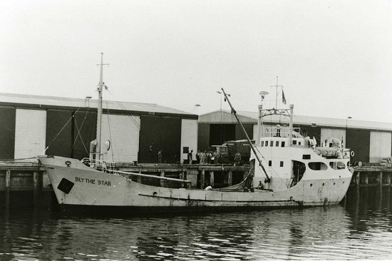
CSIRO scientists have used bathymetry and cameras to confirm the location of the wreck of MV Blythe Star.
By Craig Davey, Phil Vandenbossche and Augustin Deplante, CSIRO
Early in the evening on Friday, 12 October 1973, the 44-metre coastal freighter MV Blythe Star cast its lines and departed Hobart bound for Currie on King Island. Aboard were 10 crew and a cargo of beer and fertiliser, the latter of which filled the vessel’s hold and was stacked atop its hatch covers.
In the days that followed, the ship and disappeared without a trace. This triggered the largest maritime search ever conducted in Australia to that time and led to important changes in maritime safety laws in Australia, improving safety at sea for future mariners.
Unbeknown to the rest of the world for nearly two weeks, the Blythe Star had suddenly listed then sunk off the southwest coast of Tasmania on the morning of 13 October. All 10 crew were able to escape the sinking vessel and climb into an inflatable life raft. Tragically, three crewmembers died before the survivors — who, at the mercy of ocean currents, drifted up and down the Tasmanian coast in the life raft — were rescued on 24 October.
No trace of the Blythe Star was found.
Ending a 50-year mystery
A few months shy of the 50th anniversary of its disappearance, the location of the wreck of the Blythe Star was confirmed by scientists aboard the CSIRO research vessel RV Investigator during a voyage off the west coast of Tasmania. The primary purpose of the voyage, led by the University of Tasmania, was to study a massive submarine landslide on the continental shelf in the region.
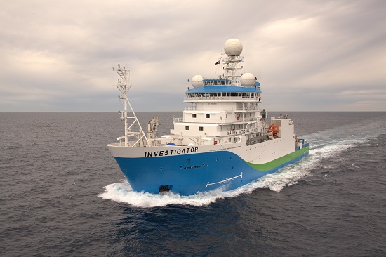
The voyage included a ‘piggyback’ project to investigate an unidentified shipwreck in the area, suspected to be that of the Blythe Star. Piggyback projects are added to voyages where spare capacity or capability of the Investigator can be used to deliver additional projects of national benefit. The project was led by CSIRO’s Geophysical Survey and Mapping (GSM) team in collaboration with the CSIRO Seagoing Instrumentation Team (SIT) on board.
The unidentified shipwreck had been pinpointed by fishing vessels and previous seafloor surveys in the region. It is not uncommon for shipwrecks to be located by fishing vessels.
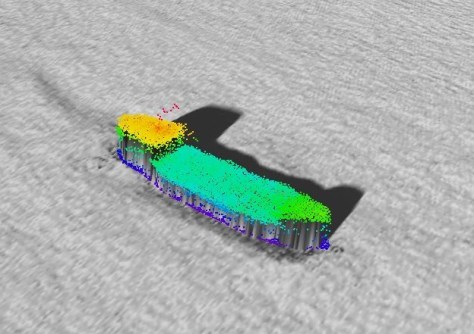
On 12 April 2023, Investigator completed a systematic bathymetric survey of the unidentified shipwreck and surrounds. The survey was undertaken using the vessel’s Kongsberg EM710-Mk2 multibeam echosounder operating at frequencies of 70 to 100 kHz. A narrow swath angle of 30° to port and starboard was selected for the survey. A data grid of 0.5-metre resolution was applied in map production. However, all soundings (points of data) were retained for point cloud visualisations. The EM710-Mk2 can map the seafloor down to approximately 1,600 metres at these frequencies.
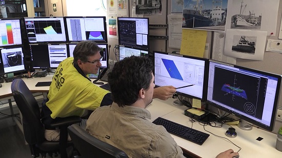
Following the mapping and guided by the imagery that had been collected during the survey, two underwater camera systems were deployed from the Investigator to conduct visual inspections of the shipwreck. The first system used was a dedicated drop camera system, capable of being deployed to depths of 6,000 metres. The second system was a specialised deep towed camera system; this is generally used for towed surveys of the seafloor but was configured for use as a drop camera for this deployment. The deep towed camera can be deployed to depths of 3,900 metres. The camera systems were deployed and operated by members of the SIT in partnership with the ship’s crew from ASP Ship Management.
Project outcomes
The bathymetry data located the unidentified shipwreck lying in approximately 150 metres of water. The shipwreck was intact and sitting upright on the seafloor, orientated with the bow pointing towards the northwest. Importantly, the bathymetry showed that the shipwreck matched the dimensions and profile of the Blythe Star.
Visual inspection delivered a definitive outcome. Deployment of the drop camera focused on searching for features from the stern through to the bow that could confirm the shipwreck identity. Careful manoeuvring of the camera and close inspection by the project team enabled the vessel name to be identified on the bow of the shipwreck, with S-T-A-R being just visible. This, combined with confirmation of other distinctive features, confirmed that the wreck was that of the Blythe Star.

The bathymetry and visual inspection showed the vessel was intact and in relatively good condition, covered with a minimal growth of algae and seaweed. The superstructure showed some signs of damage, possibly caused during its sinking or resulting from fishing trawls catching on it over the years. Most notably, the vessel’s wheelhouse is no longer present and there is a large depression in the seafloor at midship’s on the port side.
Some debris was observed around the Blythe Star, including the front of the wheelhouse seen on the seafloor on the port side and what appears to be a large box located on the seafloor near the stern on the starboard side. The site was also found to have abundant marine life, with schools of small fish, crayfish and several fur seals spotted by the underwater cameras.
It is hoped that the bathymetry and camera imagery gathered may provide additional information to help answer questions about what caused the vessel to sink.
Recording Australia’s underwater heritage
The data and video footage from the project have been provided to both state and national maritime heritage agencies as part of the reporting process for the Australasian Underwater Cultural Heritage Database (AUCHD). The AUCHD contains historical and environmental information about shipwrecks, sunken aircraft and other types of underwater heritage sites located in the Oceania and Southeast Asian regions.
Importantly, the project included CSIRO maintaining close liaison and providing regular updates to stakeholders who had direct connection with the Blythe Star. This is an important part of any project that involves underwater cultural heritage.
CSIRO, Australia’s national science agency, is pleased to be able to assist in providing closure to this 50-year mystery and confirm the resting place of the Blythe Star. The project was supported by a grant of sea time on Investigator by the CSIRO Marine National Facility.


