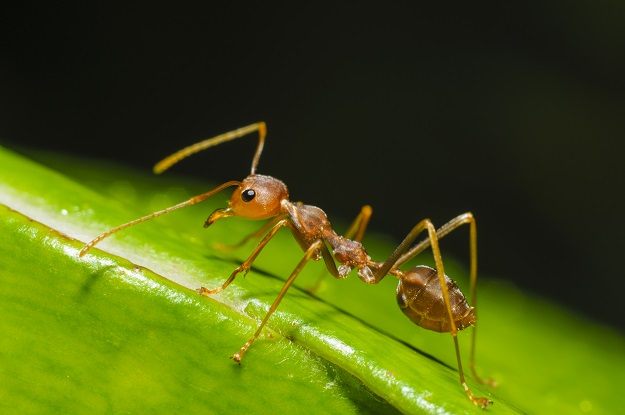
Red imported fire ants are serious threat to the Australian environment. Image © iStockphoto/toktak_kondesign.
Over the end-of-year period, we’ll be reprising some of the best of the articles we’ve published over the past 12 months. We hope you enjoy catching up on what was making news in 2021.
By Gabriel Scarmana and Kevin McDougall
Geospatial information and tools have played (and may further play) an important role in identifying potential sites of fire ant infestations and, at the same time, have lent a hand in modelling and predicting the spread of these invasive pests.
The methods used by local or state agencies and authorities to control the spread of pests varies depending on the type of pest, severity of infestation, and in some cases, local regulations and policy regarding the use of chemicals and pesticides. Education is also a significant focus in any eradication initiative by alerting the public to the problem, advising how to limit the spread of the pest by reducing or eliminating potential breeding habitats, and how and when to report sightings.
Therefore, it is reasonable to suggest that using a combination of education, preventative measures and control techniques, the pest control agencies can fulfil their task of reducing and, better still, eliminating problems caused by pests.
One of the keys to reaching this goal is the requirement to carefully track and monitor sightings and incidents. However, estimating range boundaries of infestations is challenging because monitoring or surveillance methods are imperfect, the region might be infrequently or only partly surveyed and the species may have sporadic distributions.
Monitoring is costly, time consuming and requires the use of innovative approaches. The lack of reliable data often results in an underestimation of the range and extent of boundaries of the pest infestation.
Meet the enemy
The identification of fire ants’ (Solenopsis Invicta) actual and/or potential nesting areas is crucial for many reasons. It is not just another invasive ant; it is a pest that, without an eradication program in place, will have an impact that can exceed the combined effects of many of the other pests presently regarded as very dangerous imported species (Fire Ant Biosecurity Zone Changes, Queensland, July 2020, https://www.youtube.com/watch?v=TmjQKdaRdCk).
In Queensland, fire ants were first discovered near the Port of Brisbane around 20 years ago. Infestations have now been found across the Greater Brisbane area, Ipswich, Lockyer Valley and the Gold Coast. South American in origin, the red imported fire ant has been accidentally introduced in Australia, New Zealand, several Asian and Caribbean countries and the United States.
Red imported fire ants are small, with workers ranging from 2 to 6 mm in length. They are a shiny brown/red colour, with abdomens normally darker than their heads. They are aggressive and rush to the surface to protect their nests whenever they sense a disturbance. With strong mandibles they can deliver very painful stings (like a bee sting). In countries where they have become established, people have died due to stings because of severe allergic reactions (ie. anaphylactic shock).
Fire ant infestation areas can expand naturally each year as nests produce queens to start new nests. They can fly as far as a couple of kilometres from the parent colony, but can be carried further on the wind. However, the biggest problem is that nests often get moved in soil and plants by businesses in the building, landscape and agriculture industries. Home owners can also move nests unwittingly during renovations and landscaping.
Recently in several areas of the Gold Coast, a substantial number of infestations were identified. As a consequence warning signs have been erected and pamphlets have been distributed to the general public to indicate the presence and hazards posed by this species.
If they become established, not only will they affect the local environment, they will impact the Australian way of life, reducing the use of local parks, sports ovals and even our own backyards due to the risk of injuries or fatalities. Similarly, devastating impacts and costs have been reported in many sectors, such as agriculture, communications, electrical, tourism, the environment, infrastructure (eg. roads, airports) and schools and hospitals.
GIS to the rescue
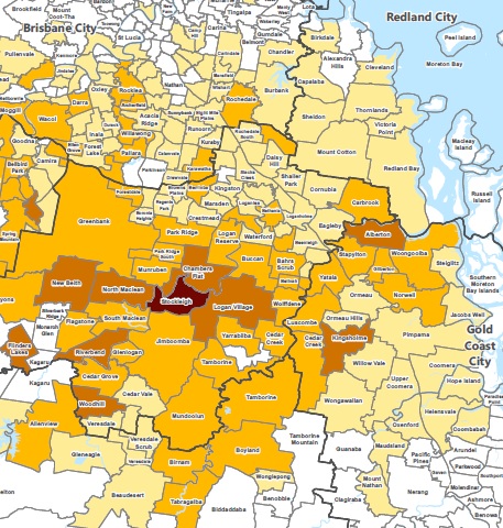
The map shown here represents an indicative example of a GIS output showing the extent and detection of the red imported fire ants on the Gold Coast for the period March 2020 to May 2021. The map is based on the percentage of the total properties for each individual suburb as related to the highest number of detections occurred during the above period (1% to 10% – Low to High). The absence of reported detections does not imply the complete absence of fire ants in the area. Likewise, this does not denote that the areas covered or shown by the map are overrun with fire ants. Note that all new detections are effectively destroyed, either through the implementation of treatment procedures or through planned eradication or suppression treatment.

This map shows the extent and detection of the red imported fire ants on the Gold Coast for the period March 2020 to May 2021 – white indicates no detections, dark brown indicates a high level of detections. © The State of Queensland, Department of Natural Resources and Department of Agriculture & Fisheries 2021.
Fire ants nests are difficult to spot, especially when they are in their early stages. But when they become bigger they have a number of distinctive features: a small dome shaped mound (up to 40 cm high), and a pile of loose dirt with no obvious entrances often found on open grassy areas or next to objects on the ground (poles, fences, rocks, pavers, pavement).
Since first being detected in Queensland in 2001, attempts to eradicate this biological invader have not been entirely successful, despite concerted efforts and surveillance methods. There exist several surveillance practices which have been implemented for their eradication. These comprise (not in order of importance and not limited to):
- Visual surveillance by field teams
- Odour detection dog teams
- Remote sensing surveillance
- Community surveillance and reporting
These methods and applications are defined in the Ten-Year Eradication Program (South East Queensland 2017–18 to 2026–27) by the Queensland Department of Agriculture and Fisheries (https://www.daf.qld.gov.au/business-priorities/biosecurity/invasive-plants-animals/ants/fire-ants). According to this thorough and publicly available material, the usefulness and need for each of these methods are expected to be reviewed on a regular basis during the ten-year plan to guarantee that the most proficient and effective techniques are used. In addition, new surveillance methods will be investigated as they emerge over the life of the plan.
GIS is an ideal tool for managing data about the nature, location and spread of pests. Storage of vast amounts of data about the type of pest, including reports on where it has been spotted and when, enables tracking and predictive analysis and allows for timely preventative measures to be deployed.
GIS can also be used to track the success of such actions, such as monitoring the results of a treatment program. However, accurate information about the nature and location of the problem must first be collected. GNSS systems provide an ideal solution for collecting such data, as they allow accurate position information to be gathered along with necessary descriptive data.
GNSS-based data collection systems typically enable a data dictionary, or data structure, to be pre-defined. This ensures that the correct information is collected, and in a way that is compatible with the selected GIS database. Some GNSS-based systems also enable upload of existing GIS data and descriptive imagery. This enables the user to accurately navigate back to treatment areas for monitoring and further scrutiny.
Attribute information can be easily updated in the field, with changes automatically logged, to enable accurate charting of the results of a treatment or preventive plans. GNSS systems that are specifically designed for use in GIS data collection provide extensive functionality — capturing more than just an accurate position, they provide the ability to record exactly what is happening in the field. As part of mobile mapping technology, there are a number of integrated (GNSS-GIS) field data collection systems that can assist in detection and surveillance.
By the same token, GIS site suitability analysis methods may also be considered a complementary method for optimising the surveillance/treatment tasks and therefore improving the detection and reduction of the spread of infestations. GIS site suitability analysis incorporates the development and refinement of land classification/aptness methods that relate to the identification of preferred nesting habitats. Suitability analysis can also be used to assess potential spread patterns of the species.
The battleground
Since there are several GIS-based site suitability and selection processes, it is important to recognise when to use one method rather than another. For instance, fuzzy logic site selection can be a viable choice as it is mostly utilised in projects that have an element of uncertainty or where the user cannot state specifically where a site would be, such as in the case of a potential site of infestation. Fuzzy analysis also reduces some of the constraints that can lead to uncertainty in the results.
In particular, choosing and weighting criteria can be tricky, because decision makers are not perfect and can influence the results with personal preferences. In other words, fire ants don’t make decisions based on discrete variables and/or polygons like the ones we see in maps. Thus, fuzzy logic can assist in considering unsuspected areas which still have a risk of fire ants’ presence. Suitability site analysis is part and parcel of well established GIS-based software such as ESRI ArcGIS, MapInfo or QGIS (open source).

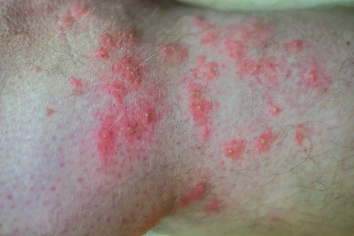
Red fire ants are aggressive, and can leave victims with many nasty bites. Image © iStockphoto/photographereddie.
To carry out this suitability analysis, it is crucial to obtain accurate geospatial data and be guided by the expertise of those working to eradicate the pests, as well as research findings on the factors or variables that determine preferred nesting locations and potential spread patterns.
Once this data is available, the next stage is to combine and overlay the geospatial data using the criteria relating to the preferred habitat. In terms of the factors or criteria selection, the National Red Imported Fire Ant Eradication Program provides the following advice to assist land managers in prioritising areas for proactive treatment/surveillance of fire ants:
New developments. Fire ants have been known to prefer open, disturbed habitats, with numerous studies indicating they spread to recently cleared areas, such as new developments, ie. where the land has been disturbed in the last one to three years. Disturbance can include activities such as excavation/earthworks, vegetation clearing, and replacement of fill, turf or gardens. For example, in May 2021 several active nests were detected in the Gold Coast suburb of Yatala within an industrial estate under development.
Waterways. Nests are often found around bodies of water such as lakes and dams.
Waste management facilities. These are high risk sites for fire ant infestation. They not only provide ideal habitat (open, regularly disturbed areas) but also receive waste materials that may bring in the ants.
Low vegetation cover. Fire ants are more likely to inhabit open, sunny spaces as opposed to areas with high tree or bush coverage. Priority treatment should be focused on land with less than 25% vegetation cover.
Proximity to other active or previous treated sites. Fire ants are known to fly up to five kilometres to find an area to build a new nest. Priority should be given to suitable habitats within this radius of a known infestation.
Topography. Relatively flat and pastoral areas are at risk.
These characteristics can be included in a fuzzy overlay analysis, reclassified and weighted to produce a suitability map depicting the most suitable and least suitable habitats.
Modelling techniques, like humans, are not perfect and need to be continually reviewed and refined to improve accuracy. Comparing predicted habitats to actual sightings and infestations enables not only calibration of the model but also the potential to train it. Artificial intelligence and machine learning can enable a suitable model to improve its predictions by adding rules and learnings, similar to how we learn from our mistakes.
Aerial observation
Ground surveillance and detection is costly and labour intensive, so remote sensing technologies using airborne cameras have been used to capture large areas quickly and efficiently. For instance, with cameras mounted beneath a helicopter (which flies over the target area at an altitude of approximately 150 metres) it is possible to capture up to 750 hectares per day per camera. These images are captured at visible, near-infrared and thermal wavelengths.
Nests have a distinctive size and shape, but, more importantly, in suitable weather conditions they are approximately 10°C hotter than the surrounding ground. However, the technology requires fine weather to be effective and can only be used during the cooler months, when soil temperatures are low enough to provide contrast with the nests. Based on Bureau of Meteorology records, the necessary weather conditions occur about 100 days per year. Remote sensing is often prioritised at the edges of the infestation where expansion could potentially take place.
Like fuzzy logic modelling, remote sensing is not perfect and may throw up false positives and false negatives. That is why careful calibration and ground truthing are needed to improve the accuracy and reliability of the system to ensure its results can be used with confidence.
In summary, using a combination of the above geospatial methods of land suitability analysis and field data collection techniques, detection and surveillance have the potential to further improve turnaround time on reporting while reducing operating costs. Field staff can be used more productively as they are able to visit more sites in a day, and accurate positional information allows easy relocation of treatment sites for re-inspection and monitoring.
Utilising state-of-the-art geospatial information capture, storage and analysis enables accurate monitoring of pest management activities and the timely application of preventative measures. Financial savings are also realised, as spraying and poisoning methods can be used more wisely and efficiently. In addition, public safety issues can be addressed as the spread of pests can be more accurately predicted and controlled.
Gabriel Scarmana and Kevin McDougall are researchers at the University of Southern Queensland. Scarmana maintains a research interest on site suitability analysis and modelling using GIS–based spatial multi-criteria evaluation.
Stay up to date by getting stories like this delivered to your inbox.
Sign up to receive our free weekly Spatial Source newsletter.


