An investigation by CSIRO, conducted for Heritage NSW, has helped identify the wreck of a steamship that disappeared off the New South Wales coast in 1904.
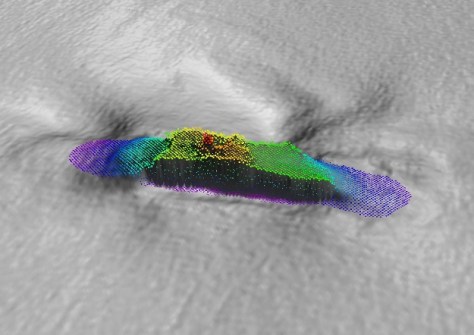
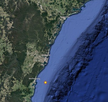
On 8 July 1904, the 73-metre-long steamship, SS Nemesis, departed Newcastle bound for Melbourne with a cargo of coal and coke. Shortly after, the vessel ran into a strong southerly gale and large swells, and was seen struggling to make headway in waters off Wollongong on 9 July.
The Nemesis then disappeared at sea with the tragic loss of all 32 lives. What happened to the vessel, and its final resting place, would become one of NSW’s enduring maritime mysteries.
After nearly 120 years, that mystery has now been solved.
In May 2022, Subsea Professional Marine Services discovered an uncharted wreck while conducting a survey off Wollongong. Subsea reported the wreck to Heritage NSW, the agency responsible for maritime heritage management in NSW. From the imagery collected by Subsea, Heritage NSW suggested that the wreck could be the Nemesis. However, strong currents at the wreck site hampered further surveys to gather additional data.
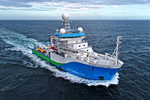
Heritage NSW then asked the CSIRO to investigate the wreck using CSIRO research vessel RV Investigator, should the opportunity arise, to assist in gathering further data and imagery to aid in its identification.
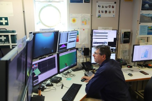
Fortuitously, Investigator was able to assist and conducted a detailed seafloor mapping and camera investigation of the wreck while on a transit voyage from Hobart to Sydney in September 2023.
Investigation by Investigator
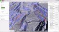
CSIRO mapping specialists used Investigator’s advanced multibeam echosounders (MBES) to map the wreck and surrounding seafloor in high resolution. They followed this with a systematic visual inspection of the entire wreck site using a specialised underwater drop camera system.
The system used for the multibeam bathymetry survey was a Kongsberg EM710 MK2, operating at a frequency of 70-100 kHz. The CSIRO team designed the survey grid specifically to map along both the length and across the shipwreck, with line spacings that allowed significant overlap for a beam angle setting of 30° (to port and starboard).
In total, 18 survey lines were run in dual swath mode and with a combination of equidistant and equiangular beam spacing settings to maximise the soundings across the wreck. A bathymetry gridding resolution of 0.5 metres was selected, but all soundings were retained for the point cloud. Data processing and visualisation were undertaken with Caris HIPS and SIPS and QPS Fledermaus software.
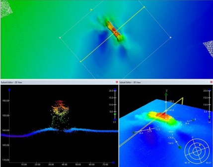
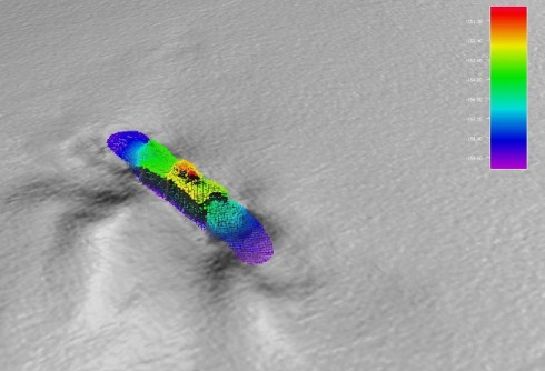
Phil Vandenbossche, a CSIRO hydrographic surveyor on board the Investigator, said the bathymetry shows the wreck is lying at a depth of 160 metres approximately 28 kilometres off the coast of Wollongong, NSW.
“The wreck is located towards the edge of the continental shelf and is sitting upright on the seafloor but is showing significant damage and deterioration at both the bow and stern,” Vandenbossche said.
“It’s lying in a southeast to northwest orientation, with the bow pointing towards the northwest. However, due to the degree of damage, it wasn’t until we located a ship’s anchor in the camera investigation that we were entirely sure which was the bow and stern.”
The bathymetry also shows two large areas of seafloor scouring on the port (south) side of the wreck. These were investigated during the camera survey but nothing significant was found.
After the multibeam echo sounder survey had been completed, the data were processed and the imagery was used to aid in the precise positioning of Investigator for the drop camera investigation. The drop camera was deployed and tested with lights on and off. However, it was determined that there was too much reflection with the lights on and, surprisingly, there was sufficient ambient light at 160 metres depth to conduct the entire camera investigation without artificial lighting.
CSIRO voyage manager, Jason Fazey, said the Investigator was in the right place at the right time to assist Heritage NSW and conduct the survey.
“Our voyage track took us right past the wreck and we were extremely lucky with the conditions for the survey, with our team on board doing a superb job in mapping and capturing incredible imagery of the wreck,” he said.
Confirming the wreck’s identity
The bathymetry and camera survey data, along with the previous imagery collected by Subsea, provided substantial detail to enable Heritage NSW’s maritime archaeology experts to identify the wreck as the Nemesis.
Principle amongst these is a thick hull ‘sheer strake’, an unusual feature for this class of vessel and a notable feature of the Nemesis. Other evidence included the hatch and deck structure locations, the number of ventilators, the engine type and overall structural layout mapped to surviving historic ship’s plans, as well as the apparent cargo of coal.
Senior Maritime Archaeologist with Heritage NSW, Dr Brad Duncan, said locating and identifying the Nemesis was a highly collaborative effort between research and heritage agencies, and the maritime community.
“This discovery and confirmation of the wreck’s identity not only provides significant archaeological information about the ship and wrecking event but, more importantly, may offer some solace to the families of those who perished onboard as it provides a location at which they can mourn their loved ones,” Dr Duncan said.
The wreck of the Nemesis is one of many thousands of shipwrecks that lie along the Australian coastline, with many still to be found. It is protected as a historic shipwreck under the Underwater Cultural Heritage Act 2018.
The project was supported by an allocation of sea time on RV Investigator by the CSIRO Marine National Facility, national research infrastructure supported by the Australian Government’s National Collaborative Research Infrastructure Strategy (NCRIS) and operated by CSIRO on behalf of the nation.