Leica Geosystems’ groundbreaking Multistation combines a robotic total station with 3D laser scanning capabilities.
PARTNER FEATURE
As any surveyor will tell you, time is money on all construction projects. Time setting up, time gathering data — often having to use separate instruments — time dealing with interruptions, time processing the information gathered.
So imagine being able to perform all your tasks quickly, efficiently, automatically and with high accuracy, using a single device. The Leica Geosystems Nova MS60 MultiStation is the answer… a groundbreaking instrument that enables surveyors to do all that and more.
Leica describes the Nova MS60 as “the world’s first self-learning MultiStation,” and it’s easy to see why. It is a scanning total station that enables complete data collection of individual points and large areas by leveraging sensor fusion and automation, self-learns on the job, and seamlessly integrates with Leica field and office surveying software… enabling the user to quickly complete their work on-site and move on to the next project.
The MS60 scans at up to 30,000 points per second, completing work quickly and producing dense scanning grids. It features optimised scanning paths, including zenith scans, enabling the user to significantly reduce the total scanning time, and has 1″ angular accuracy, a 2,000-metre range for distance measurements to any surface and a 10,000-metre range to a prism.
The in-built digital imaging technology includes an overview and a 30x magnifying telescope camera, resulting in accurate, image-assisted surveying.
By combining these functions of a high-end robotic total station for single point surveys and 3D laser scanning capabilities, the MS60 — available in Australia through C.R. Kennedy — means surveyors are always equipped for anything on site and across their workflow.
In-built excellence
The MS60’s capabilities don’t stop there. Built in is a range of features such as ATRplus, Dynamic Lock and AutoHeight, which work together to enhance the instrument’s versatility and adaptability.
ATRplus is the self-learning element. This feature absorbs information about the surrounding environment and adjusts the MS60’s settings to achieve the best possible measurement performance. For example, it learns the weather conditions to evaluate visibility and can determine foreign reflections, ensuring the instrument stays on its target.
Dynamic Lock searches for, aims at and tracks the prism, including rapid relock on a lost prism, bringing clear benefits on busy construction sites or in dense traffic areas where frequent line-of-sight interruptions occur.
The AutoHeight feature measures instrument height quickly and precisely with a single button press, eliminating common errors of reading and entering the station height.
These three features alone offer vastly improved consistency and accuracy and reduced setup times, enabling more points to be measured or laid out over the day.
The MS60’s improvements in scanning capabilities include increased scan speeds, new modes for more-efficient point cloud generation, and on-site point cloud analysis with Leica Captivate field software apps. The new scan modes, based on a spiral scan pattern, see the MS60 scan while rotating 360 degrees per second. In zenith, the instrument generates a regular point spacing, optimises the point cloud with fewer overlapping points, enables a faster scan performance and more consistent data — of benefit when measuring a ceiling or working inside a tunnel.
The MS60 also offers the option to start and stop a scan on demand and repeat previous scans without redefinitions, along with the ability to transfer prior scan definitions to different jobs or even different instruments.

The MS60 is fully compatible with Leica Captivate surveying field software, Leica Infinity surveying software and the Leica AP20 AutoPole — all available through C.R. Kennedy — and excels at a range of traditional and non-traditional surveying and scanning applications, such as:
- Surfaces and volumes in construction and mining, soil heaps and stockpiles, DTM creation and checking surfaces, material thickness, blast faces and ground levels.
- Analysis of complex structures and objects within plant, marine and utility projects, dimensional control, as-built and record keeping.
- Measuring buildings and structures, bridge condition/clearance analysis, BIM and as-built.
- For facade, elevations and heritage work, the creation of traditional deliverables such as 2D maps or 3D models
- Deformation monitoring of structures and ground: automated or periodic measurements of buildings, transportation infrastructure, natural hazards, dams and other objects
And if that wasn’t enough, the MS60 supports theft deterrence and fleet management with Leica LOC8, a tool that uses GPS or Wi-Fi tracking to let owners understand where their assets are located. With LOC8, owners can define geofenced areas and receive alerts if their instrument is moved beyond the boundaries. In the case of theft, LOC8 enables remote locking and recovery assistance through tracking links that can be shared with police.
Putting it to work
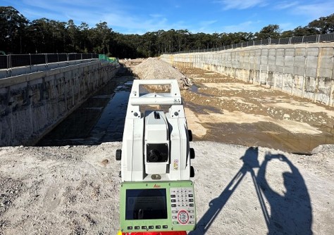
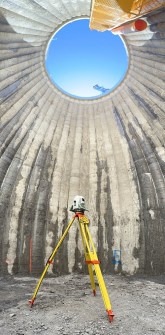
One local company that is already reaping the benefits of using the MS60 is GC Surveyors, whose Civil Survey Manager, Morris Massetti, sings the instrument’s praises. Having first become acquainted with the MS60 at the Hexagon Expo in Las Vegas, Massetti began using the instrument in his work at GC Surveyors, and, in particular, he has been using its Inspect Surfaces App to boost his workflow productivity.
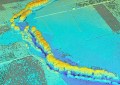
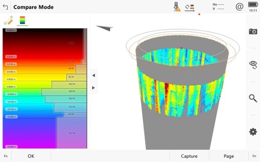
“With the Leica Inspect Surfaces, I’m able to drastically reduce the time between the field work and the deliverable requested from the client, providing a report which is not only quick but also full of details like heat map section and dynamic data table, where you can actually inspect and check every single point collected,” he says.
The power of the MS60 means that Massetti is able to spend more time in the field collecting data and viewing it on a tablet, and less time back in the office having to process that data.
“If you plan a specific scan area, you can directly import and process it into the tablet without going physically into the office. Literally you can generate a report within 10 minutes from the completion of the scan,” he says.
“The app is simple to use and everything is built into it,” he adds. “You only need to set up a few steps to get any report generated.”
Another advantage of the MS60 is the service and support provided by C.R. Kennedy. The MS60 and its range of associated accessories (e.g. prisms, tripods, software) are fully supported by experienced C.R. Kennedy sales and technical staff who know surveying inside and out. Whether it’s assistance with choosing the right combination of equipment, or answering technical questions in the field, help is just a phone call away.
“Morris and GC Surveyors are really pushing the boundaries of the Captivate software to take advantage of the MS60’s Inspect Surfaces capabilities and demonstrate what it’s capable of,” says Nathan Thompson, NSW Geodesy Sales Manager at C.R. Kennedy. “Being able to get a real-time view of the data captured is a huge time-saver.”
Massetti says that he uses the MS60 to target jobs that require a quick turnaround between the field work and the report. “The M60 is able to eliminate the office work and at the same time provide an incredible amount of detail compared to the design info,” he says.
Summing up, Massetti says that “the MS60 allows you to step above traditional but critical survey tasks by accelerating your workflow, drastically improving the accuracy and the amount of data collected, reducing the time from the start to the end of the task”.
For more information on the MS60, contact your local C.R. Kennedy office or visit https://survey.crkennedy.com.au.