

James Cook University researchers have developed an AI algorithm that fuses different types of satellite imagery for high-precision oil spill spotting from space.
The work could prove crucial for future environmental monitoring.
The study’s authors say this is the first time AI has been used to combine two types of satellite imagery to detect the location, thickness and type of oil spills in oceanic waters, providing a new tool for fast and accurate response plans.
“This is a major step forward in oil spill detection, and it will allow us to detect spills more accurately and tell whether the oil is thick or thin,” said lead researcher and JCU PhD candidate Quanwei Liu.
When crude oil spills into the ocean, it disperses due to the action of currents, wind and waves, increasing the extent of the contamination.
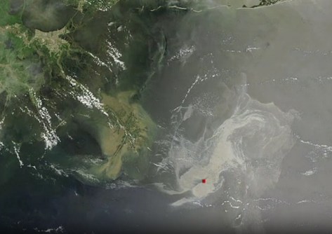
For example, the 2010 Deepwater Horizon oil spill leaked millions of barrels of oil from around 1.5 km below the sea surface, to eventually cover roughly 12,000 square kilometres of ocean. (See the photo at the top of the page.)
Two satellites are better than one
Detecting and monitoring oil spills using satellite imagery has proven essential for addressing and mitigating oil spill hazards. However, combining the data of different satellite imagery for more accurate detection has proven challenging, until now.
“We combined inputs from two types of satellite: the synthetic aperture radar (SAR) and the hyperspectral imaging satellite (HSI),” said JCU’s Dr Kevin Huang, who supervised the study.
“SAR can detect the differences in waves and surface roughness of the ocean. If there’s oil on the surface of the water, it’ll make the surface smoother. But alone, it often confuses thin versus thick oil.
“HSI acts like a super-detailed colour sensor that helps determine what the spilled oil material is, but it doesn’t generalise as widely.
“Fusing them captures the best of both — cleaner spill outlines and stronger oil-type recognition — beating other approaches.”
Faster responses
Practically, the researchers suggest a simple response plan: use SAR for fast, large-area detection following a spill, then apply the SAR+HSI fusion inside the detected area to estimate oil thickness/type and guide clean-up decisions.
Both scientists argue that this approach is not only important for addressing oil spills but could also prove valuable for future monitoring in a wide range of environmental contexts.
“We want to further apply our deep learning and remote sensing research to other monitoring applications, like water quality, forests and disasters, to benefit societies and communities,” Dr Huang said.
The work has been published in Remote Sensing Applications: Society and Environment.


