

Researchers from the University of Leeds have unveiled a neural network that can rapidly and accurately chart the expanse of large Antarctic icebergs in satellite images, accomplishing the task in a mere 0.01 seconds.
Anne Braakmann-Folgmann, lead author of the findings published in The Cryosphere, conducted her research during her tenure as a PhD student at the University of Leeds in the UK.
Now working at the Arctic University of Norway in Tromsø, she emphasises the significance of large icebergs in the Antarctic environment.
“Giant icebergs are important components of the Antarctic environment. They impact ocean physics, chemistry, biology and, of course, maritime operations. Therefore, it is crucial to locate icebergs and monitor their extent, to quantify how much meltwater they release into the ocean,” said Dr Braakmann-Folgmann.
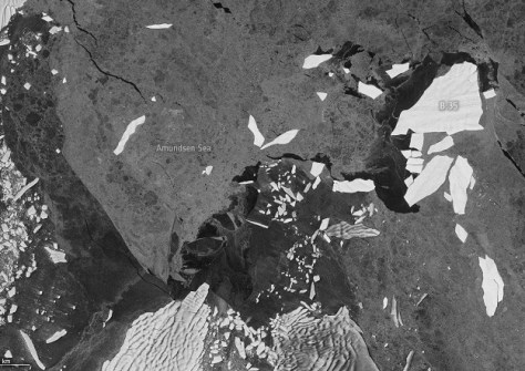
Data from the Copernicus Sentinel-1 radar mission has played a vital role in the new approach of using AI to map icebergs.
Although icebergs appear as bright objects against the darker ocean and sea-ice background in most of the Sentinel-1 images, it can still be difficult to separate icebergs from sea ice or the from the coastline when the environment is complex.
“We have sometimes struggled to separate icebergs from surrounding sea ice that is rougher and older, and therefore looks brighter in the satellite images. The same applies to wind-roughened ocean,” said Dr Braakmann-Folgmann.
“Also, smaller iceberg fragments, which occur frequently near icebergs as they constantly lose bits of ice around their edges, are easily grouped together with the main iceberg by mistake.
“In addition, the Antarctic coastline may resemble icebergs in the satellite images, so standard segmentation algorithms often select the coast too instead of just the actual iceberg.”
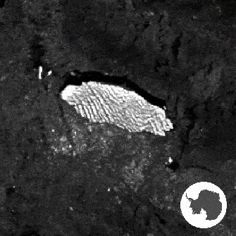
The neural network approach, on the other hand, makes mapping iceberg extent easy, even in these challenging conditions.
The neural network architecture is based on the U-net design, and was meticulously trained using Sentinel-1 images exhibiting giant icebergs in various settings, with manually-derived outlines serving as the target.
The algorithm has been tested on seven icebergs, ranging in size from 54 sq km to 1052 sq km. A diverse dataset was compiled, incorporating between 15 and 46 images for each iceberg, spanning various seasons and the years 2014 to 2020.


