


NASA Visible Earth visualisation by Marit Jentoft-Nilsen
Australia gets down-to-earth about shifting into orbit, with input invited into a new 2030 industry plan.
By Alison Bowman
A national coalition of leading organisations have come together to explore the industry opportunities for Australia at the intersection of ‘space’ and ‘spatial’. Convened by Peter Woodgate — former CEO of CRCSI and now founding Chair of SmartSat CRC — this influential group drawn from industry, research and government is coordinating an ambitious initiative to create the ‘Space+Spatial Industry Roadmap 2030’.
The space and spatial industries have never been more important for the future of Australia. They both have a fundamental role to play in helping navigate the response to catastrophic bushfires, the impacts of climate change and the development of recovery plans for the economy following the global pandemic. The growth of these two industries will have a profound effect on the well-being of Australia over the next decade and beyond.
“Together these sectors face a once in a century opportunity,” said Woodgate. “This is an industry driven movement to focus on the immediate and medium-term wins that are achievable for Australian businesses, scientists and professionals if only we take smarter, informed action.”
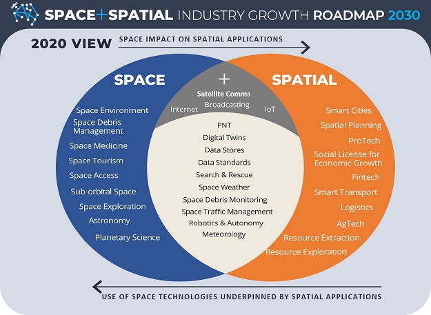
The combination of space and spatial working together adds enormous value. In many ways these two industries are co-dependent and synergistic. The space industry sets up critical elements of the communications supply chain — through satellite communications together with vital content from Global Navigation Satellite Systems (GNSS) and earth observation sensors. The spatial industry provides the vast bulk of the subsequent data infrastructure, value-added content and analytics, and the ‘last yard’ delivery channels to customers and end users for most industries.
FrontierSI’s CEO Graeme Kernich sees this roadmap as the natural progression of the 2026 Agenda, which delivered a roadmap to drive growth, coordinate effort, and transform the spatial sector. “We are seeing technological change present the opportunity for space and spatial businesses to work together to integrate information workflows faster and cheaper,” he said. “This will improve the service offerings and operational efficiencies.”
Over the past year peak industry bodies including the Surveying & Spatial Sciences Institute (SSSI), the Spatial Industries Business Association/ Geospatial Information & Technology Association ANZ (SIBA | GITA), the Space Industry Association of Australia (SIAA) and Earth Observation Australia (EOA) have been working toward developing the Space+Spatial Industry Roadmap 2030 under the leadership of SmartSat CRC and Frontier SI. The steering committee also includes a number of government organisations — ANZLIC, Geoscience Australia, CSIRO and the Department of Defence.
The industry driven Roadmap will draw attention to the interlinkages between space and spatial, and the steps required to more closely integrate and generate growth within these sectors. Not only will a more strategic and integrated approach lead to increased productivity in key Australian economic sectors, but the benefits are also expected to accrue through:
- increased participation in the global space and spatial industries
- improved access to surety for Australia’s information supply chains
- increased efficiency in the delivery of state and government services, and
- improved planning to ensure skills gaps are filled to meet required growth.
Stronger integration will also accelerate innovation and productivity gains in key Australian sectors including agriculture, mining, aviation and intelligent transport, through improved coordination between end users and technology and data providers.
“Many people in society hear ‘space’ and think deep space missions to the Moon and Mars,” said Chair of the SIAA, Dr Tim Parsons. “Actually, the rapid development and innovation we’re seeing today around near-Earth orbit systems and technologies is the real-world opportunity for advancing Australia’s future sustainable economic prosperity. So I welcome this chance to explore how ‘space+spatial’ can work together.”
Industry input invited
A Roadmap consultation paper has been released that highlights key priorities for feedback. It focuses on issues that have not yet been factored into the many existing strategies and plans of the agencies, organisations and companies that have contributed to the draft paper.
“What’s new and different with this exploratory outreach and consultative paper is that it’s uniquely driven by industry, for industry, but we also have some of the most influential government agencies talking with us as well,” said Glenn Cockerton, a national director of SIBA | GITA. “This program isn’t about policy but mobilising the industry for the coming years.”
“We’re now looking to enable geospatial professionals right across Australia to have their say on these opportunities via direct online feedback, video roundtables and live local discussion.”
“This is about building new and expanding existing capability within individual businesses,” added Tony Wheeler, CEO of SSSI. “It’s also an important opportunity to have your say through a timely national consultation and to connect into a diverse circle of large and small organisations and thought leaders.”
The Roadmap aims to drive the conversation about what Australia needs, and industry participation is vital. This includes discussion on sovereignty, Australia’s growing security dependence on space and the increasing vulnerability of space capabilities. The delivery of space-enabled services depends on reliable and continued access to satellite data. Australia does not have a history of national ownership of space-based remote sensing and navigation systems. Instead, our approach has been to exploit other nations’ space capabilities through international partnerships, taking a ‘multi-source’ approach by which Australia integrates data from different suppliers.
“Some think that Australia is too small to play in this arena,” said Peter Kerr, Space+Spatial Roadmap coordinator and Defence advisor to SmartSat CRC. “Bigger countries with well-established space sectors tend to be caught in entrenched interests and approaches. But in the 21st century the space industry is very different, more affordable and with many niche specialist options.
“As a relatively recent entrant to this marketplace, we think Australia can be more agile in how our industries take advantage of the new opportunities.”
“There is a huge home-grown multi-billion market just in defence, but we urgently need to build both capabilities and capacity,” added Kerr. “In addition, this effort may prove to be valuable in meeting the rapidly growing needs of earth observation and space-based programs in India, Asia and the Middle East as well as the US and Europe.”
It is also timely to examine the many significant spatial data stores within Australia’s government agencies and research organisations and the risks to these national data stores, their infrastructure, systems and analytics. Indeed, the augmentation of GNSS constellations with regional systems such as satellite-based augmentation systems (SBAS) will lead to greater reliance on positioning, navigation and timing (PNT) capabilities, enabled by federal investment in the Positioning Australia program.
In order to capitalise on expected demand for a PNT system which is accessible, accurate and available for all Australian sectors, a major challenge will be developing indigenous capabilities that assure PNT services across the nation by improving its resilience, robustness and trustworthiness over the long-term.
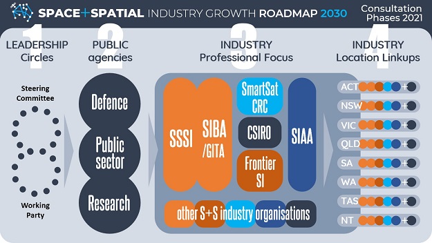
The national consultation program is being co-designed by Cofluence — the Canberra team that facilitated the 2026 Agenda and produced the ‘Space Meets Spatial’ event at Locate 2018. “In 2021 we hope to be hosting all kinds of meeting spaces between these two industries,” said Allison Hornery. “Since working with NASA on a global hackathon in 2012 we’ve always seen the potential for stronger alignment between space and geospatial.”
“This comprehensive interaction program started with influential leadership circles and current feedback coming in from government, public sector and defence arenas,” added Cofluence partner, John Wells. “But now it’s time for the ‘Industry Professional Focus’ phase where national peak bodies, member networks and associations are co-convening dialogue and feedback opportunities. Everyone can have a say and shape their ‘space+spatial’ future.”
“SSSI looks forward to our members joining with other geospatial colleagues as well as space sector innovators in more location-based video meetups,” said Wheeler. “We’ll certainly be encouraging the ‘coffee break conversations’ among members and partners. Other organisations might also wish to convene their own.”
Input from the consultative dialogue sessions will help finalise the Space+Spatial Industry Growth White Paper as well as the Space+Spatial Industry Roadmap 2030 before the end of this year. To register interest, read the draft paper and provide feedback, or find how your organisation can host a session or be involved, visit the website at https://2030spaceandspatial.com.
Alison Bowman is Media and Communications Officer at the SmartSat CRC.
This article was first published in issue 113 of Position magazine.
Stay up to date by getting stories like this delivered to your inbox.
Sign up to receive our free weekly Spatial Source newsletter.


