


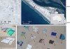
The first data from the new SPOT 6 satellite has been successfully received and processed in Russia. Data was received using the "UniScan" ground station in Moscow Remote Sensing Center of ScanEx RDC on October 17, 2012. Software developed within the frames of the international cooperation with the satellite operator, Astrium GEO-Information Services, […]
Search results for "SPOT 6"

SPOT 6 satellite launched
The SPOT 6 Earth observation satellite, built by Astrium, was successfully launched last week by a PSLV launcher from the Satish Dhawan Space Center in India. It will join in orbit Pléiades 1A, the very high resolution Earth observation satellite, with products distributed by Astrium Services. Both satellites will first work together and […]
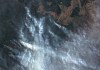
Plastic rubbish on beaches spotted from space
RMIT scientists have developed a satellite imagery spectral index for detecting plastics on beaches.

Survey spotlights drone industry trends
The Australian Association for Uncrewed Systems’ latest survey attracted feedback from 145 organisations.
Shining a spotlight on bushfire monitoring
The Digital Earth Australia Hotspots program uses near-real-time satellite imagery to detect and monitor fires.
LatConnect 60, SSTL in ‘Space Bridge’ partnership
LatConnect60 will access high-resolution panchromatic and multispectral optical data from SSTL’s S1-4 satellite.
Microsatellite sends multispectral image 16 days after launch
Slovenia has released a colour image from the NEMO-HD microsatellite built by SFL in collaboration with SPACE-SI.
Humans force wild animals into tight spots, or send them far from home
Australian researchers calculate just how big the impact is.
CSIRO illuminates ‘bright spots’ in coastal ecosystem restoration
Strategy to vastly expand coastal ecosystem restoration for widespread benefits.

LatConnect 60 satellite data to feature on UP42 marketplace
Earth observation data from Perth’s LatConnect 60’s planned constellation will feature on the UP42 marketplace.
