A new satellite-based remote sensing tool analyses spatial and temporal vegetation change near mining sites.
To better assess the spatial extent of mining facilities and their environmental impact, a research team at the Helmholtz-Zentrum Dresden-Rossendorf (HZDR) has developed a satellite-based remote sensing tool.
SHABA, which stands for Seasonal Harmonic Anomaly Break Analysis, is a satellite-based innovative tool to analyse spatial and temporal vegetational dynamics.
Unique in its ability to factor in seasonal fluctuations and trends to reliably detect and quantify changes in vegetation, researchers hope that SHABA will help better assess the global environmental impact of mining.
Global mining of metals and the facilities built to extract them have significant environmental impacts.
“In Europe, operators are obligated to ensure that their operations comply with the law. In other regions of the world, regulations may differ from ours,” said Prof. Richard Gloaguen, head of the Department of Exploration at HZDR’s Helmholtz Institute Freiberg for Resource Technology (HIF).
“Up to now, the land footprint of global mining has been inadequately quantified because we had no remote sensing tool to reliably monitor and quantify the environmental impact of the thousands of mines worldwide that underpin metal supply chains.”
Reliably detecting changes in vegetation
The team led by Gloaguen SHABA to reliably detect changes in vegetation around mining sites.
“A crucial feature is SHABA’s ability to factor in typical seasonal changes in vegetation, such as leaf fall or blossoming periods, and also to compare data with previous years’ trends,” said Vincent E. Nwazelibe, a scientist in Gloaguen’s research group and the study’s first author.
“This allows SHABA to reliably detect changes in vegetation and pinpoint them precisely in space and time.”
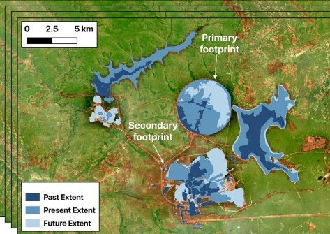
In their study, the researchers used SHABA to scan the vegetation surrounding six mining sites on different continents and in different climatic zones.
For each site, they analysed satellite data of the vegetation within a radius of up to 100 kilometres from the sites from 2000 to 2025, generating over a hundred satellite images per year and site.
“SHABA converts the vegetation data from the satellite images into a clear wave diagram, which makes it easy to see and quantify any significant changes in the vegetation at a specific location,” said Dr. Samuel Thiele, head of the Digital Data Processing group in the Exploration Department at HIF.
The changes in vegetation that SHABA picked up at the mining sites matched related events in the area at the given times. For example, loss of vegetation caused by deforestation — to expand a mining site or build an access road — or gradual gains in vegetation in the wake of recultivation efforts.
Plans for analysing all mines, worldwide
“Our study demonstrated SHABA’s potential as a remote sensing tool for vegetational analysis in the vicinity of mining facilities across a wide variety of climatic regions around the world,” says Gloaguen.
“We hope that SHABA will help quantify the land footprint of mines worldwide and that its unbiased remote sensing data will facilitate a better dialogue between stakeholders on both sides, mining and environmental protection.”
In further studies, the research team plans to use SHABA to analyse all mines worldwide and make the collected monitoring data available at no cost. The SHABA remote sensing tool is already freely accessible.
The research has been published online: V. E. Nwazelibe, M. Kirsch, S. T. Thiele, F. Djeddaoui, W. Yu, R. Gloaguen, R. Tolosana-Delgado, Monitoring mining impacts using harmonic decomposition of time series vegetation indices, in ISPRS Journal of Photogrammetry and Remote Sensing, 2026 (DOI: 10.1016/j.isprsjprs.2026.07.001).